
National Register of Historic Places listings in Big Cypress National Preserve facts for kids
Big Cypress National Preserve is a huge swampy area in Florida, United States. It's a special place where you can find amazing wildlife and beautiful nature. But did you know it's also home to many important historical sites? These sites tell us about the people who lived here long, long ago.
This article will tell you about the places in Big Cypress National Preserve that are listed on the National Register of Historic Places. This is a special list that helps protect important historical spots across the country.
Contents
What is the National Register of Historic Places?
The National Register of Historic Places is like a special "hall of fame" for buildings, places, and objects that are important to American history. When a place is added to this list, it means it's recognized for its historical, architectural, or archaeological value. It helps make sure these places are protected and remembered for future generations.
In Big Cypress National Preserve, there are nine places that have been added to this important list. Most of them are ancient sites where people lived thousands of years ago.
Protecting Hidden Treasures
Many of the historic sites in Big Cypress National Preserve have "Address Restricted." This means their exact location isn't shared publicly. Why? Because these places are very old and fragile, and keeping their location secret helps protect them from damage or people taking things from them. These sites often contain clues about ancient cultures, like tools, pottery, or old village layouts.
Here are some of these important, protected sites:
- Burns Lake Site (8CR259): This site was added to the list in 1986. It's near Ochopee.
- Halfway Creek Site: Listed in 1980, this site is close to Carnestown.
- Hinson Mounds: These mounds, listed in 1978, are near Miles City. They might be ancient burial grounds or places where people built their homes.
- C. J. Ostl Site: This site, added in 1978, is also found near Ochopee.
- Plaza Site (8CR303): Another site near Ochopee, listed in 1986.
- Sugar Pot Site: This site, listed in 1978, is also located near Ochopee.
- Turner River Site: Added to the list in 1978, this site is found near Ochopee.
These sites give archaeologists and historians clues about how early people lived in the Big Cypress area. They help us understand their daily lives, their tools, and their connection to the land.
Platt Island: A Visible Historic Spot
Unlike many of the restricted sites, Platt Island has a more public location. It's found northeast of Miles City, off State Road 29. This site was added to the National Register in 1978. It's an important place that shows us more about the history of the area.
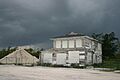
A Story of the Past: Monroe Station
Not all places stay on the National Register forever. Sometimes, things happen that cause them to be removed from the list. One such place was Monroe Station, located near Ochopee.
Monroe Station was a historic building at the junction of the Tamiami Trail and Loop Road. It was added to the National Register in 2000. However, it was sadly destroyed by a fire. Because it no longer existed, it was removed from the list in 2019. Even though it's gone, its history is still remembered.
Images for kids
-
Monroe Station before it was destroyed by fire.

