
National Register of Historic Places listings in Bingham County, Idaho facts for kids

Welcome to Bingham County, Idaho! This page is all about special places here that are listed on the National Register of Historic Places. This is a list of important buildings, sites, and areas in Bingham County, Idaho, that the United States government has recognized as worth saving. These places tell us a lot about history, like how people lived, worked, and built things long ago.
There are currently 18 amazing places in Bingham County that are on this list. More places are added all the time across the country, so this list might grow!
Contents
- What is the National Register of Historic Places?
- Historic Places in Bingham County
- Aviator's Cave
- Historic Buildings in Blackfoot
- Blackfoot I.O.O.F. Hall
- Blackfoot LDS Tabernacle
- Blackfoot Railway Depot
- Eastern Idaho District Fair Historic District
- Idaho Republican Building
- J.W. Jones Building
- North Shilling Historic District
- Nuart Theater
- St. Paul's Episcopal Church
- Shilling Avenue Historic District
- Standrod Bank
- US Post Office-Blackfoot Main
- Historic Sites in Fort Hall
- Images for kids
What is the National Register of Historic Places?
The National Register of Historic Places is like a special "hall of fame" for buildings, structures, objects, sites, and districts that are important in American history, architecture, archaeology, engineering, or culture. When a place is added to this list, it means it's recognized for its unique value and efforts are made to protect it for future generations. It's a way to celebrate and keep alive the stories of our past.
Historic Places in Bingham County
Let's explore some of the cool historic places you can find in Bingham County:
Aviator's Cave
- Aviator's Cave is a unique natural site located on the grounds of the Idaho National Laboratory near Arco. It was added to the Register on July 22, 2010. This cave has a fascinating history, possibly linked to early aviation or exploration in the area.
Historic Buildings in Blackfoot
Many of Bingham County's historic places are in the city of Blackfoot. These buildings show us what the town was like in earlier times.
Blackfoot I.O.O.F. Hall
- The Blackfoot I.O.O.F. Hall is at 57 Bridge Street. It was listed on May 15, 1979. I.O.O.F. stands for "Independent Order of Odd Fellows," which was a friendly society that helped people in the community. This building was likely a meeting place for them.
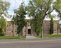
Blackfoot LDS Tabernacle
- The Blackfoot LDS Tabernacle is a beautiful church building at 120 South Shilling Street. It joined the Register on September 19, 1977. Tabernacles are large meeting halls used by members of The Church of Jesus Christ of Latter-day Saints.
Blackfoot Railway Depot
- The Blackfoot Railway Depot is located at 130 Northwest Main Street. It was added on November 20, 1974. Train depots were once very busy places where people traveled and goods were shipped. Today, this historic depot is home to the Idaho Potato Museum, which is a fun place to learn about Idaho's famous potatoes!
Eastern Idaho District Fair Historic District
- The Eastern Idaho District Fair Historic District is a whole area at 97 Park Drive. It was listed on August 10, 2001. This district includes buildings and grounds that have been part of the Eastern Idaho State Fair for many years. Fairs are important community events that bring people together.
Idaho Republican Building
- The Idaho Republican Building is at 167 West Bridge Street. It was added on October 16, 1979. This building likely housed a newspaper or a political office, playing a role in the local news and government of its time.
J.W. Jones Building
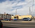
- The J.W. Jones Building can be found at 104 Main Street, Northeast. It was listed on November 17, 1982. This building is an example of the kind of businesses and shops that were important to Blackfoot's growth.
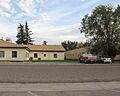
North Shilling Historic District
- The North Shilling Historic District covers an area along North Shilling Avenue. It became a historic district on August 29, 1979. Historic districts are groups of buildings that together show a significant part of a town's history or architectural style.
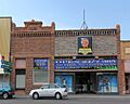
Nuart Theater
- The Nuart Theater is at 195 North Broadway. It was added on October 19, 1978. Old theaters like the Nuart were once popular places for movies and live shows, bringing entertainment to the community.
St. Paul's Episcopal Church
- St. Paul's Episcopal Church is located at 72 North Shilling Avenue. It was listed on May 15, 1979. This church is an important part of Blackfoot's religious and community history.
Shilling Avenue Historic District
- The Shilling Avenue Historic District includes Shilling Avenue between East Idaho and Bingham Streets, and also from Bridge and Judicial Streets to Stout Avenue. It was added on August 18, 1983. This district highlights more of Blackfoot's historic architecture and town planning.
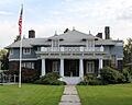
Standrod Bank
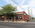
- The Standrod Bank is found at 59 and 75 Main Street, West. It was listed on August 30, 1979. Banks are crucial to a town's economy, and this building shows us what financial institutions looked like in the past.
US Post Office-Blackfoot Main
- The US Post Office-Blackfoot Main is at 165 West Pacific. It was added on March 16, 1989. Post offices have always been vital for communication, connecting people through letters and packages.
Historic Sites in Fort Hall
The Fort Hall area also has some very important historic listings.
Fort Hall Site
- The Fort Hall Site is located about 16 miles north of Fort Hall. It was listed on November 21, 1974. This site is where the second Fort Hall stood from 1870 to 1883. Fort Hall was a very important trading post and stop along the Oregon Trail and other pioneer routes.
Lincoln Creek Day School
- The Lincoln Creek Day School is on Rich Lane, about eight miles southeast of Idaho State Highway 91 near Blackfoot. It was added on April 9, 2010. Day schools like this were important for educating children in rural areas.
Ross Fork Episcopal Church
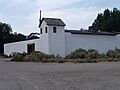
- The Ross Fork Episcopal Church is on Mission Road. It was listed on January 3, 1983. This church served the community in the Fort Hall area.
Ross Fork Oregon Short Lines Railroad Depot
- The Ross Fork Oregon Short Lines Railroad Depot is on Agency Road. It was added on September 7, 1984. Like the Blackfoot depot, this railroad station was a key part of transportation and trade for the Fort Hall area.
Images for kids
-

Aviator's Cave, a unique natural site.
-
The Blackfoot I.O.O.F. Hall.
-
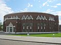
The Blackfoot LDS Tabernacle.
-

The Blackfoot Railway Depot, now the Idaho Potato Museum.
-

Part of the Eastern Idaho District Fair Historic District.
-
A replica of Fort Hall, representing the historic site.
-
The Idaho Republican Building.
-
The J.W. Jones Building.
-
A building within the North Shilling Historic District.
-
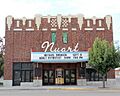
The historic Nuart Theater.
-
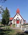
The Ross Fork Episcopal Church.
-

The Ross Fork Oregon Short Lines Railroad Depot.
-

St. Paul's Episcopal Church.
-
A building within the Shilling Avenue Historic District.
-
The historic Standrod Bank.
-

The US Post Office-Blackfoot Main.


