
National Register of Historic Places listings in Boone County, Arkansas facts for kids

This article is about special places in Boone County, Arkansas, that are listed on the National Register of Historic Places. These are important buildings, sites, or objects that are recognized for their historical or architectural value. Think of it like a "hall of fame" for old and important places!
These places are officially recognized by the United States government. This helps to protect them and make sure they are preserved for future generations. There are 20 such places listed in Boone County.
Contents
What is the National Register of Historic Places?
The National Register of Historic Places is America's official list of places that are important to our history. It includes buildings, structures, objects, sites, and districts. When a place is added to this list, it means it has a special story to tell about the past.
Why are places added to the Register?
Places are added to the Register for many reasons. They might be very old, show a special style of building, or be connected to important events or people. For example, a school where many famous people studied, or a bridge built in a unique way. Listing a place helps people learn about its history and encourages its protection.
Historic Places in Boone County
Boone County has several interesting places on the National Register. Let's explore some of them.
Historic Homes and Buildings
Many homes and public buildings in Boone County have historical importance.
Elliott and Anna Barham House
This house is located in Zinc. It was added to the Register in 2004. It's an example of a historic home from the area.
Boone County Courthouse
The Boone County Courthouse in Harrison was listed in 1976. Courthouses are often important community buildings. They are where local laws are made and justice is served. This building has been a central part of Harrison for a long time.
Boone County Jail
Also in Harrison, the old Boone County Jail was added in 1976. Old jails can tell us a lot about how communities handled law and order in the past.
Duncan House
The Duncan House in Harrison was listed in 2005. This is another example of a historic home that shows the architectural styles of its time.
Evans-Kirby House
The Evans-Kirby House, also in Harrison, joined the Register in 2005. It's another important historic residence.
Schools and Education
Several old schools in Boone County are recognized for their history.
Bergman High School
Bergman High School in Bergman was listed in 1992. Old school buildings often hold many memories for a community. They show how education has changed over the years.
Cottonwood School No. 45
The Cottonwood School #45 near Self was added in 2002. This school building represents the history of rural education in the county.
Everton School
The Everton School in Everton was listed in 1992. It's another example of a historic school building.
Grubb Springs School
Near Harrison, the Grubb Springs School was added in 1996. These old schools are important reminders of how communities grew and provided education for their children.
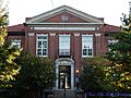
Harrison High School
The Harrison High School building in Harrison was listed in 2007. This school has been a key part of the community's educational journey.
Valley Springs School
The Valley Springs School in Valley Springs was listed in 1992. It's another historic school building in Boone County.
Bridges and Transportation
Bridges are often important for connecting communities and showing engineering skills of the past.
Haggard Ford Swinging Bridge
The Haggard Ford Swinging Bridge is located over Bear Creek, north of Harrison. It was added in 1995. Swinging bridges are unique and were important for crossing rivers before modern bridges were common.
Zinc Swinging Bridge
The Zinc Swinging Bridge in Zinc was listed in 2007. This is another example of a historic swinging bridge in the county.
Other Notable Sites
Bear Creek Motel
The Bear Creek Motel near Bear Creek Springs was listed in 2001. Motels like this were important for travelers in the past, especially as car travel became popular.
Carrollton Road-Carrollton Segment
This historic road segment near Carrollton was listed in 2008. Old roads can tell us about early travel and trade routes.
Cricket and Crest Tunnels Historic District
This district near Omaha was added in 2007. It includes a pair of old railroad tunnels. Railroads were very important for moving goods and people across the country. These tunnels show the engineering needed to build railways through difficult terrain.
Harrison Courthouse Square Historic District
This district in Harrison was listed in 1999. It includes the area around the courthouse, which often has many historic buildings and is the heart of a town.
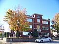
Hotel Seville
The Hotel Seville in Harrison was added in 1994. Historic hotels often have grand architecture and were important gathering places for travelers and locals.
Missouri and North Arkansas Depot-Bellefonte
This old train station in Bellefonte was listed in 1992. Train depots were vital hubs for communities, connecting them to the wider world.
Twelve Oaks
The Twelve Oaks property near Harrison was listed in 2010. It is another significant historic site in the county.
Images for kids
-

The historic Bear Creek Motel.
-
The Boone County Courthouse in Harrison.
-

The Cricket and Crest Tunnels near Omaha.
-

The Everton School building.
-

The Grubb Springs School.
-

The Haggard Ford Swinging Bridge.
-
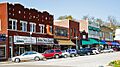
Downtown Harrison, part of the Courthouse Square Historic District.
-
The Harrison High School building, now the Boone County Heritage and Railroad Museum.
-
The historic Hotel Seville in Harrison.


