
National Register of Historic Places listings in Boone County, Indiana facts for kids

Welcome to Boone County, Indiana! This page is all about the special places here that are listed on the National Register of Historic Places. Think of the National Register as a very important list of buildings, areas, or objects across the United States that are worth saving because of their history, architecture, or what they mean to our country.
When a place is on this list, it means it's recognized as important and efforts are made to protect it for future generations. In Boone County, there are 15 amazing places and areas that have earned a spot on this list. Some are old buildings, some are farms, and some are even whole neighborhoods!
Contents
- Cool Historic Places in Boone County
- Boone County Courthouse
- Pryor Brock Farmstead
- Strange Nathanial Cragun House
- Howard School
- Lebanon Courthouse Square Historic District
- Maplelawn Farmstead
- Oak Hill Cemetery
- Scotland Bridge
- Simpson-Breedlove House
- Thorntown Public Library
- Traders Point Eagle Creek Rural Historic District
- Traders Point Hunt Rural Historic District
- Town Hall (Castle Hall)
- Ulen Historic District
- Andrew B. VanHuys Round Barn
- Images for kids
Cool Historic Places in Boone County
Let's explore some of the cool historic spots you can find in Boone County:
Boone County Courthouse

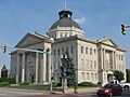
Located right in the heart of Lebanon, the Boone County Courthouse is a really important building. It's where a lot of the county's official business happens. This impressive building was added to the National Register in 1986. It stands proudly on Courthouse Square, a central spot in the city.
Pryor Brock Farmstead

Out west of Zionsville, in Eagle Township, you'll find the Pryor Brock Farmstead. This farm is special because its buildings show off a style called "Italianate" architecture. It's like a piece of art made by a carpenter! This farm reminds us of a "golden age" when farming was a huge part of Indiana's history. It was listed in 2008.
Strange Nathanial Cragun House

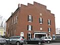
Another historic home in Lebanon is the Strange Nathanial Cragun House. You can find it on West Main Street. This house was added to the National Register in 2011, recognizing its historical value.
Howard School

North of Brownsburg, in Perry Township, stands the old Howard School. This building holds memories of many students who learned here long ago. It became a historic site in 2009.
Lebanon Courthouse Square Historic District

Not just the courthouse, but the whole area around it in Lebanon is a historic district! This means many buildings in that area, roughly bounded by North, East, South, Superior, and West Streets, are important together. This district was recognized in 2016.
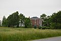
Maplelawn Farmstead

Near Zionsville, in Eagle Township, is the Maplelawn Farmstead. This historic farm was added to the National Register in 2011. It helps tell the story of farming life in the past.
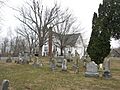
Oak Hill Cemetery

Even cemeteries can be historic! Oak Hill Cemetery in Lebanon is a peaceful and important place. It was listed in 2014, showing its significance to the community's history.
Scotland Bridge

East of Mechanicsburg, you can find the Scotland Bridge. This bridge crosses Sugar Creek and is so important that it's listed on the National Register. It was added in 1994 and even stretches into Clinton County!
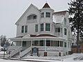
Simpson-Breedlove House

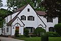
The Simpson-Breedlove House, located on U.S. Route 421 in Union Township, is another historic home. It was officially recognized in 2016.
Thorntown Public Library

The Thorntown Public Library is more than just a place to borrow books; it's a historic building! Located on North Market Street, it was added to the National Register in 1986.
Traders Point Eagle Creek Rural Historic District

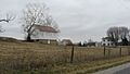
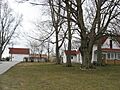
This large historic district, mainly in Eagle Township, shows what rural life was like. It's roughly between Interstate 865, Interstate 465, and Lafayette Road. It was listed in 2009 and even extends into Marion County.
Traders Point Hunt Rural Historic District

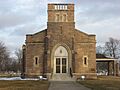
Another rural historic district near Zionsville, in Eagle Township, is the Traders Point Hunt Rural Historic District. It's roughly bounded by State Road 334, Interstate 865, Old Hunt Club Road, and County Road 850E. This area was recognized in 2009.
Town Hall (Castle Hall)

In Zionsville, the Town Hall, also known as Castle Hall, is a very old and important building. You can find it on East Cedar Street. It was added to the National Register way back in 1983.
Ulen Historic District

The Ulen Historic District in Ulen includes the Ulen Country Club and Golf Course, along with houses on Ulen Boulevard and East Drive. This area was listed in 2015, showing its unique history and design.
Andrew B. VanHuys Round Barn

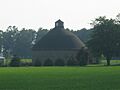
South of Lebanon, in Center Township, you can see a very special building: the Andrew B. VanHuys Round Barn. Round barns are quite rare and interesting! This one was added to the National Register in 1993.
Images for kids
-
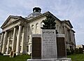
The grand Boone County Courthouse in Lebanon.
-
The Pryor Brock Farmstead, showing its unique architecture.
-
The Strange Nathanial Cragun House in Lebanon.
-
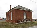
The old Howard School building.
-
A view of the Lebanon Courthouse Square Historic District.
-
The Maplelawn Farmstead, a historic farm near Zionsville.
-
The chapel at Oak Hill Cemetery in Lebanon.
-
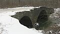
The Scotland Bridge over Sugar Creek.
-
The Simpson-Breedlove House.
-
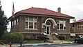
The Thorntown Public Library.
-
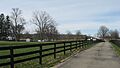
A farm within the Traders Point Eagle Creek Rural Historic District.
-
Salem United Methodist Church, part of the Traders Point Hunt Rural Historic District.
-
The historic Town Hall in Zionsville.
-
A house in the Ulen Historic District.
-
The unique Andrew B. VanHuys Round Barn.
