
National Register of Historic Places listings in Brazos County, Texas facts for kids

This article is about the special places in Brazos County, Texas that are listed on the National Register of Historic Places. These are buildings, areas, or other spots that are important because of their history, architecture, or what happened there. Think of it like a national hall of fame for historic sites!
When a place is added to this list, it means it's recognized as a valuable part of American history. This helps protect these places so future generations can learn from them and enjoy them. Most of the places on this list are in the city of Bryan.
Contents
What is the National Register of Historic Places?
The National Register of Historic Places is the official list of places in the United States that are worth saving. It's managed by the National Park Service. Being on this list helps protect these sites and sometimes provides money to help keep them in good shape.
These places can be buildings, structures, objects, sites, or even entire historic neighborhoods. They are chosen because they tell important stories about our past. They might be where famous people lived, where important events happened, or they might show amazing old building styles.
Historic Gems in Bryan, Texas
Brazos County has many amazing historic places, especially in Bryan. These sites tell us about the people and events that shaped the area. Let's explore some of them!
Old Buildings with Stories
Many buildings in Bryan have been around for a long time and have interesting histories. They show us how people lived and worked in the past.
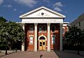
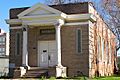
Bryan Carnegie Library
The Bryan Carnegie Library is a beautiful old building located at 111 S. Main Street. It was built in 1903 with money from Andrew Carnegie, a famous businessman who helped build many libraries. This library served the community for many years and is a great example of early 20th-century architecture. It was added to the National Register on October 27, 1976.
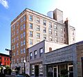
La Salle Hotel
The La Salle Hotel, found at 120 S. Main Street, is another important building. It was built in 1928 and was a popular place for travelers and locals. Hotels like the La Salle were once busy centers of town life. This hotel was added to the National Register on May 26, 2000. It shows us what grand hotels looked like almost a hundred years ago.
Bryan Municipal Building
The Bryan Municipal Building, at 111 E. 27th Street, was once the main government building for the city of Bryan. It was built in 1937 and is a good example of the architecture from that time. This building played a key role in the city's daily operations for many years. It joined the National Register on February 20, 2002.
Homes from the Past
Many historic houses in Bryan are also on the National Register. These homes give us a peek into the lives of families who lived in Brazos County long ago.
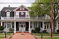
R. Q. Astin House
The R. Q. Astin House is located at 508 W. 26th Street. This house was built in 1905 and is a great example of the homes from that era. It was listed on the National Register on September 25, 1987. Imagine the families who lived here and the stories their walls could tell!
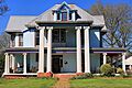
Cavitt House
The Cavitt House, at 713 E. 30th Street, is another historic home. It was built in 1880, making it one of the older houses on the list. This house was added to the National Register on October 27, 1976. It shows us the style of homes built in Bryan in the late 1800s.
English-Dansby House
The English-Dansby House, at 204 W. 28th Street, was built in 1904. It's a beautiful example of a historic home in Bryan. It was listed on the National Register on September 25, 1987. Just down the street, at 206 W. 28th Street, is the English-Poindexter House, also built in 1904 and listed on the same day. These two houses show the similar styles popular at the time.
Other Important Places
Beyond homes and public buildings, other types of places are also recognized for their historical value.
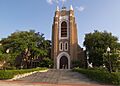
Saint Andrew's Episcopal Church
Churches often play a big role in a community's history. Saint Andrew's Episcopal Church, at 217 W. 26th Street, was built in 1914. It has been a spiritual center for many people in Bryan for over a century. It was added to the National Register on September 25, 1987.
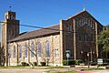
Saint Anthony's Catholic Church
Another important religious site is Saint Anthony's Catholic Church, located at 306 S. Parker Avenue. This church was built in 1927 and has a rich history within the community. It was listed on the National Register on September 25, 1987.
Temple Freda
Temple Freda, at 205 S. Parker Avenue, is a historic synagogue built in 1912. It represents the history of the Jewish community in Bryan. It was added to the National Register on September 22, 1983. This building is a reminder of the diverse groups of people who helped build Bryan.
Why are These Places Important?
These historic places are more than just old buildings. They are like living museums that help us understand the past. They show us how people lived, worked, and worshipped. By protecting them, we make sure that their stories can continue to be told for many years to come. They connect us to our roots and help us appreciate the journey of our community.
Images for kids
-

The R. Q. Astin House
-

The E. J. Blazek House
-
The Bryan Carnegie Library
-
The Bryan Ice House
-
The former Bryan Municipal Building
-

The Cavitt House
-

The Eugene Edge House
-

The English-Dansby House
-

The English-Poindexter House
-

The First National Bank and Trust Building
-

The First State Bank and Trust Building
-

The Edward J. Jenkins House
-
The La Salle Hotel
-
The McDougal-Jones House
-
The Dr. William Holt Oliver House
-
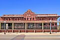
The Parker Lumber Company Complex
-
The Milton Parker House
-
Saint Andrew's Episcopal Church
-
Saint Anthony's Catholic Church
-

The Roy C. Stone House
-
Temple Freda


