
National Register of Historic Places listings in Brewster County, Texas facts for kids

This article is about special places in Brewster County, Texas, that are listed on the National Register of Historic Places. These places are important because they help us learn about history.
The National Register of Historic Places is like a special list of buildings, sites, and areas across the United States. These places are chosen because they have a lot of history or are very important to our country's past. In Brewster County, there are seven areas and five individual places on this list. Some of them are also known as Recorded Texas Historic Landmarks, which means they are important to Texas history. One is even a State Antiquities Landmark, making it extra special for the state.
Contents
Historic Places in Brewster County
Alpine Landmarks
Alpine is a town in Brewster County with some interesting historic spots.
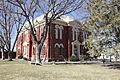
Brewster County Courthouse and Jail
The Brewster County Courthouse and Jail is a very important building in Alpine. It's located on Courthouse Square. This building is not just on the National Register of Historic Places, but it's also a State Antiquities Landmark and a Recorded Texas Historic Landmark. This means it's recognized as a key part of both Texas and national history. Courthouses are often central to a town's history, where important decisions were made and justice was served.
Nolte-Rooney House
The Nolte-Rooney House is another historic home in Alpine, found at 307 East Sul Ross Avenue. This house is also a Recorded Texas Historic Landmark. Historic homes like this one give us a peek into how people lived in the past and the styles of buildings from different times.
Big Bend National Park's Historic Sites
Many of the historic places in Brewster County are located inside Big Bend National Park. This park is famous for its beautiful desert landscapes and the Rio Grande river.
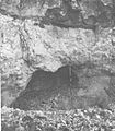
Burro Mesa Archeological District
The Burro Mesa Archeological District is a special area near Panther Junction within Big Bend National Park. An archeological district means it's a place where scientists have found old things left behind by people who lived there long ago. These findings help us understand ancient cultures and how they lived in this desert environment.
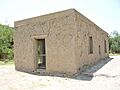
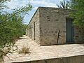
Castolon Historic District
The Castolon Historic District is located along the Rio Grande in Big Bend National Park. This area was once a small community and a military outpost. It shows what life was like for people living and working near the border in the past. You can see old buildings that tell stories of soldiers, farmers, and traders.
Daniels Farm House
The Daniels Farm House is west of Rio Grande Village in Big Bend National Park. This old farmhouse gives us an idea of what farming was like in this remote part of Texas. It shows how people used the land and water from the Rio Grande to grow crops and survive in the desert.
Hot Springs
The Hot Springs area in Big Bend National Park, west of Rio Grande Village, is known for its natural warm waters. People have visited these springs for a long time, believing they have healing powers. There are also old cabins here, showing that people used to stay for longer periods to enjoy the springs.
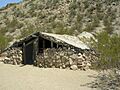
Luna Jacal
The Luna Jacal is found at the base of Pena Mountain in Big Bend National Park. A "jacal" is a type of hut or shelter, often made from natural materials like sticks and mud. This simple structure tells us about the basic living conditions of early settlers or indigenous people in the area.
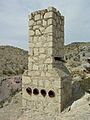
Mariscal Mine
The Mariscal Mine is located along River Road in Big Bend National Park. This was once a mercury mine, which was an important industry in this region. The remains of the mine, like its chimney, show the hard work and challenges faced by miners in the past. It's a reminder of the industrial history of the area.
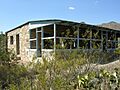
Panther Junction Mission 66 Historic District
The Panther Junction Mission 66 Historic District is the main administrative area of Big Bend National Park. "Mission 66" was a program in the 1950s and 60s to improve national parks. This district includes buildings designed during that time, showing a specific style of architecture used for park facilities.
Rancho Estelle
Rancho Estelle is another historic place located on the Rio Grande within Big Bend National Park. A "rancho" is a ranch, and this site represents the ranching history of the region. It shows how people used the land for livestock and lived off the vast, open spaces.
Homer Wilson Ranch
The Homer Wilson Ranch is about 8 miles south of Santa Elena Junction in Big Bend National Park. This ranch is another example of the ranching heritage in Brewster County. It tells the story of early settlers who raised cattle and lived in the rugged landscape of West Texas.
Terlingua Historic District
Terlingua Historic District
The Terlingua Historic District is about 7 miles west of the junction of Texas Highways 118 and 170. Terlingua was once a booming mercury mining town, often called a "ghost town" today. This historic district preserves the old buildings and structures from its mining past, letting visitors imagine what life was like when the mines were active.
Images for kids
-
Brewster County Courthouse in Alpine
-
Burro Mesa Archeological District
-

Officer's quarters at Castolon Historic District
-
Daniels Farm House
-
Cabins at Hot Springs
-
Luna Jacal
-
Chimney at Mariscal Mine
-
.
Barker Lodge at Panther Junction
-

Sublett farm house, part of Rancho Estelle
-

Terlingua Historic District
-
Homer Wilson House


