
National Register of Historic Places listings in Brookings County, South Dakota facts for kids

This page is about special places in Brookings County, South Dakota that are listed on the National Register of Historic Places. This register is like a special list kept by the United States government. It helps protect buildings, sites, and objects that are important to history. When a place is on this list, it means it's worth saving for future generations to learn from and enjoy.
Brookings County has 40 places on this important list. One place was on the list before but has since been removed. These places include old buildings, parts of towns, and even some unique structures. They tell us stories about how people lived, worked, and built things in the past.
Contents
Cool Historic Places in Brookings County
Many different kinds of places in Brookings County are on the National Register. Let's explore some of them!
Buildings in Brookings City
The city of Brookings, South Dakota has many historic buildings. These places show us how the city grew over time.
Brookings City Hall
The Brookings City Hall is an important building where the city's government works. It was added to the list in 1982. This building has seen many important decisions made for the community.

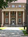
Brookings County Courthouse
The Brookings County Courthouse is another key building. It's where legal matters for the whole county are handled. This grand building, added in 1976, stands as a symbol of justice and community.

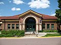
Carnegie Public Library
The Carnegie Public Library was built with money from Andrew Carnegie, a famous businessman who helped build many libraries across the country. This library, listed in 1980, has been a place for learning and reading for many years.

Chicago and Northwestern Railroad Depot
Train stations were once very busy places, connecting towns and people. The Chicago and Northwestern Railroad Depot, added in 1976, reminds us of the important role trains played in the past.

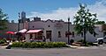
Nick's Hamburger Shop
Not all historic places are grand public buildings! Nick's Hamburger Shop is a small, famous restaurant that has been serving hamburgers for a very long time. It was added to the list in 1986 because it's a beloved local landmark.

Trygstad Law and Commerce Building
The Trygstad Law and Commerce Building is an example of a historic building used for businesses and offices. It was listed in 1984 and shows the style of older commercial buildings.

Historic Homes and Districts
Many old houses and even whole neighborhoods in Brookings County are considered historic.
Brookings Central Residential Historic District
This area is a special "historic district" because it has many old homes that show how people lived in the past. It includes streets like 3rd, 6th, Medary, and 5th Avenues. It was added to the list in 1994.

Brookings University Residential Historic District
Near the university, this district also has many historic homes. It's roughly bounded by Harvey Dunn Street, Medary Avenue, 6th Street, and Main Avenue. This area was recognized in 1999.
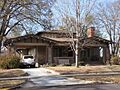
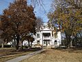
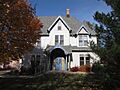
W. A. Caldwell House
The W. A. Caldwell House is a specific historic home located at 804 6th Avenue. It was added to the list in 1986.

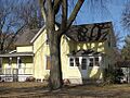
Fishback House
The Fishback House at 501 8th Street is another important historic home, listed in 1976.

Graham House
The Graham House at 927 7th Street was added to the list in 1994.

John L. Hall House
In the town of Volga, South Dakota, the John L. Hall House is a historic home at 121 Samara Avenue, listed in 2010.

E. E. Haugen House
The E. E. Haugen House at 202 5th Street in Brookings was added to the list in 2010.

Henry-Martinson House
Another historic home in Volga is the Henry-Martinson House at 405 Kasan Avenue, listed in 1977.

Lockhart House
The Lockhart House at 1001 6th Avenue in Brookings was added to the list in 2010.

George P. Sexauer House
The George P. Sexauer House at 929 4th Street is another historic home in Brookings, listed in 1990.

Solomon Walters House
In Bruce, South Dakota, the Solomon Walters House on Railway Street was added to the list in 1978.
Woodbine Cottage
The Woodbine Cottage at 929 Harvey Dunn Street in Brookings is a historic home listed in 1990.

South Dakota State University Landmarks
South Dakota State University (SDSU) in Brookings has several important historic buildings and structures on its campus.
Coolidge Sylvan Theatre
The Coolidge Sylvan Theatre is an outdoor theater area on the SDSU campus. It was added to the list in 1987.

Coughlin Campanile
The Coughlin Campanile is a tall bell tower on the SDSU campus. It's a well-known landmark and was listed in 1987.

Stock Judging Pavilion
The Stock Judging Pavilion on the SDSU campus was used for judging livestock, which is important for an agricultural university. It was listed in 1978. Today, it is home to the South Dakota Agricultural Heritage Museum.

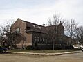
Wenona Hall and Wecota Hall
Wenona Hall and Wecota Hall are two historic dormitories on the SDSU campus, listed in 1980. They have housed many students over the years.

Experimental Rammed Earth Structures
SDSU also has some unique historic structures built using a method called "rammed earth." This is an old way of building walls by compacting moist dirt.
- The Experimental Rammed Earth Machine Shed (1993)
- The Experimental Rammed Earth Wall (1991)
- The Woodbine Cottage Experimental Rammed Earth Wall (1991)
These show early experiments with sustainable building methods.

Other Notable Historic Places
Brookings County has other interesting historic sites outside of Brookings city.
St. Mary's School (Elkton)
In Elkton, South Dakota, St. Mary's School is a historic building that served as a school for many years. It was added to the list in 1996.

Singsaas Lutheran Church
The Singsaas Lutheran Church is a historic church located in Lake Hendricks Township. Churches often play a big role in a community's history, and this one was listed in 2003.
Sterling Methodist Church
Another historic church is the Sterling Methodist Church, located near Bruce, South Dakota. It was added to the list in 1989.
Volga Auditorium
The Volga Auditorium in Volga, South Dakota is a historic building used for community events and performances. It was listed in 2000.

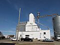
Vostad Farm
The Vostad Farm is a historic farm located near Brookings. Farms are important because they show us how agriculture shaped the area. This farm was listed in 2005.

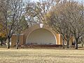
Pioneer Park Bandshell
The Pioneer Park Bandshell in Brookings is an outdoor stage where concerts and events take place. It was listed in 2007.

Sexauer Seed Company Historic District
This district is an area related to the Sexauer Seed Company, which was important for farming in the region. It includes buildings near Main Avenue and the railroad tracks. It was listed in 2001.

Herman F. Micheel Gothic Arched-Roof Barn
This barn, located near White, South Dakota, is special because of its unique "Gothic arched-roof" design. It was added to the list in 1991.
Historic Bridges
Some bridges are also considered historic because of their age or how they were built.
- South Dakota Department of Transportation Bridge No. 06-129-020 (near Bruce, listed 1999, but was destroyed in 2011)
- South Dakota Department of Transportation Bridge No. 06-142-190 (near Brookings, listed 1999)
Images for kids
-
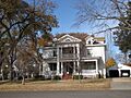
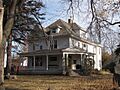
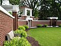
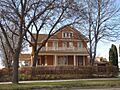
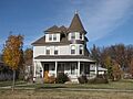
A home in the Brookings Central Residential Historic District.
-
The historic Brookings City Hall.
-
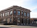
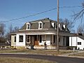
A building in the Brookings Commercial Historic District.
-
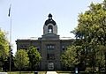
The Brookings County Courthouse.
-
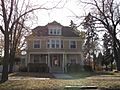
The W. A. Caldwell House.
-
The old Carnegie Public Library.
-
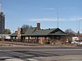
The old train station in Brookings.
-
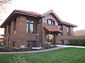
The Ivan Cobel House.
-
The Coolidge Sylvan Theatre at SDSU.
-
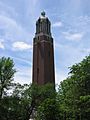
The Coughlin Campanile at SDSU.
-
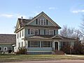
The Fishback House.
-
The Graham House.
-
The John L. Hall House in Volga.
-
The E. E. Haugen House.
-
The Henry-Martinson House in Volga.
-
The Lockhart House.
-
Nick's Hamburger Shop, a local favorite.
-
The Pioneer Park Bandshell.
-
St. Mary's School in Elkton.
-
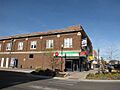
Part of the Sexauer Seed Company Historic District.
-
The George P. Sexauer House.
-
The Stock Judging Pavilion, now a museum.
-
The Trygstad Law and Commerce Building.
-
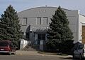
The Volga Auditorium.
-
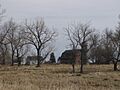
The Vostad Farm.
-
Wecota Hall at SDSU.
-
Woodbine Cottage.
-
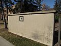
An experimental rammed earth wall at SDSU.


