
National Register of Historic Places listings in Cape Girardeau County, Missouri facts for kids

Cape Girardeau County in Missouri is home to many special places that are listed on the National Register of Historic Places. This register is like a national scrapbook of buildings, sites, and objects that are important to American history. When a place is added to this list, it means it's worth protecting and remembering for future generations.
In Cape Girardeau County, there are 58 different places on this important list. These sites include old churches, historic homes, schools, and even parts of old roads and ferry crossings. Each one tells a unique story about the past of this area.
Contents
Exploring Historic Buildings
Many buildings in Cape Girardeau County have been recognized for their historical value. These structures often show us how people lived, worked, and worshipped long ago.
Old Churches and Synagogues
Religious buildings are often central to a community's history.
- B'Nai Israel Synagogue in Cape Girardeau was listed in 2004. It's a significant place of worship for the Jewish community.
- Hanover Lutheran Church in Cape Girardeau, listed in 1987, is another important religious site. Its architecture and history reflect the early settlers of the region.
- St. James A.M.E. Church in Cape Girardeau, added in 2014, represents an important part of the African American community's history.
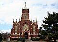
- St. Vincent De Paul Catholic Church, listed in 1982, is a beautiful church in Cape Girardeau that has been a part of the city for many years.
Schools and Colleges
Schools are places where knowledge and community grow.
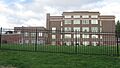
- Central High School in Cape Girardeau, listed in 2008, was originally known as the Louis J. Schultz School. It has educated many generations of students.
- Jefferson School, also in Cape Girardeau and listed in 2009, is another historic school building.
- Kage School in Cape Girardeau, listed in 2005, is an older school that shows how education was provided in the past.
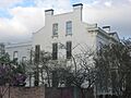
- Saint Vincent's College Building, listed in 2005, was once a college in Cape Girardeau, playing a role in higher education.
Theaters and Entertainment Spots
Even places of entertainment can be historic!
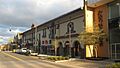
- The Broadway Theatre in Cape Girardeau, listed in 2015, was a popular spot for movies and shows.
- The Esquire Theater, also in Cape Girardeau and listed in 2005, is another historic movie theater that entertained many people.
Important Commercial Buildings
These buildings show how businesses and trade shaped the area.
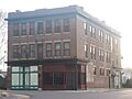
- The Himmelberger and Harrison Building in Cape Girardeau, listed in 2003, was an important commercial building.
- The Klostermann Block in Cape Girardeau, listed in 1994, is a group of buildings that were used for businesses.
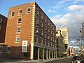
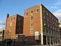
- The Marquette Hotel in Cape Girardeau, listed in 2002, was a grand hotel where travelers and locals stayed.
- The Southeast Missourian Building in Cape Girardeau, listed in 2005, housed a local newspaper, telling the stories of the community.
- The Julius Vasterling Building in Cape Girardeau, listed in 2009, is another example of historic commercial architecture.
- The Wood Building in Cape Girardeau, listed in 2003, also played a role in the city's business life.
Historic Homes and Districts
Many old homes and groups of buildings (called historic districts) are preserved because they show us how people lived and how towns grew.
Notable Houses
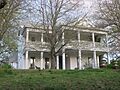
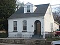
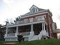
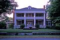
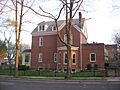
- The Bennett-Tobler-Pace-Oliver House in Jackson, listed in 1985, is a historic home with a long history.
- The Abraham Byrd House in Jackson, listed in 2007, is another example of an old family home.
- The Dr. Jean Chapman House in Cape Girardeau, listed in 2016, is a more recent addition to the list.
- The George Boardman Clark House in Cape Girardeau, listed in 1994, is a well-preserved historic residence.
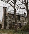
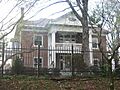
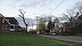
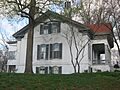
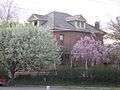
- The Frizel-Welling House in Jackson, listed in 1999, tells a story of its past residents.
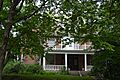
- The Glenn House in Cape Girardeau, listed in 1979, is a beautiful old home that is now a museum.
- The William Henry and Lilla Luce Harrison House in Cape Girardeau, listed in 2005, is another example of historic residential architecture.
- The House at 323 Themis Street in Cape Girardeau, listed in 1997, is a specific address recognized for its historical value.
- The Huhn-Harrison House in Cape Girardeau, listed in 2002, is another historic home.
- The Edward S. and Mary Annatoile Albert Lilly House in Cape Girardeau, listed in 2008, is a grand old house.
- The Miller-Seabaugh House and Dr. Seabaugh Office Building in Millersville, listed in 1996, shows a home and a doctor's office from the past.
- The Oliver-Leming House in Cape Girardeau, listed in 1980, is another significant historic residence.
- The Abraham Russell Ponder House in Cape Girardeau, listed in 2008, is a well-known historic home.
- The Frederick W. and Mary Karau Pott House in Cape Girardeau, listed in 1999, is another example of a preserved historic house.
- The James Reynolds House in Cape Girardeau, listed in 1983, is a historic home with unique features.
- The August and Amalia Shivelbine House in Cape Girardeau, listed in 1999, is another house that tells a story of its original owners.
- The Colonel George C. Thilenius House in Cape Girardeau, listed in 1983, is a large historic home.
- The Robert Felix and Elma Taylor Wichterich House in Cape Girardeau, listed in 1999, is a historic home with interesting details.
- The J. Maple and Grace Senne Wilson House in Cape Girardeau, listed in 2015, is a more recently recognized historic residence.
Historic Districts
Historic districts are areas with many historic buildings that together tell a story about a neighborhood or town.
- The Big Hill Farmstead Historic District in Jackson, listed in 1999, is an area with old farm buildings.
- The Broadway Commercial Historic District in Cape Girardeau, listed in 2016, includes several blocks of historic businesses.
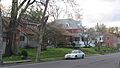
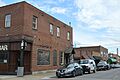
- The Broadway and North Fountain Street Historic District in Cape Girardeau, listed in 2003, is another commercial area with historic buildings.
- The Broadway-Middle Commercial Historic District in Cape Girardeau, listed in 2007, also highlights important business areas.
- The Cape Girardeau Commercial Historic District in Cape Girardeau, listed in 2000, covers a large part of the city's historic business center.
- The Courthouse-Seminary Neighborhood Historic District in Cape Girardeau, listed in 2010, includes a mix of homes and public buildings.
- The Haarig Commercial Historic District in Cape Girardeau, listed in 2000, is another commercial area with historical significance.
- The Jackson Uptown Commercial Historic District in Jackson, listed in 2006, is the historic business center of Jackson.
- The Main-Spanish Commercial Historic District in Cape Girardeau, listed in 2008, is another important commercial area.
- The South Middle Street Historic District in Cape Girardeau, listed in 2009, is a residential area with many historic homes.
- The Warehouse Row Historic District in Cape Girardeau, listed in 2004, shows the city's history as a port and trading center.
Other Important Historic Sites
Not all historic places are buildings. Some are natural sites or old infrastructure.
- The Bainbridge Ferry and Bainbridge Ferry Road in Cape Girardeau, both listed in 2007, show us where people used to cross the Mississippi River.
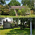
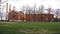
- The Burfordville Covered Bridge and Burfordville Mill near Burfordville, listed in 1970 and 1971, are part of the Bollinger Mill State Historic Site. The covered bridge is a rare sight today, and the mill shows how grain was processed long ago.
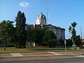
- The Cape Girardeau Court of Common Pleas, listed in 2010, is a historic courthouse where legal matters were handled.
- Green's Ferry in Cape Girardeau, listed in 2007, is another historic ferry crossing site on the Mississippi River.
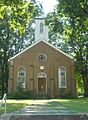
- McKendree Chapel near Jackson, listed in 1987, is an old chapel with a rich history.
- The Old Appleton Bridge in Old Appleton, listed in 2009, is a historic bridge over Apple Creek.
- The Old Lorimier Cemetery in Cape Girardeau, listed in 2005, is a historic burial ground.
- The Trail of Tears State Park Archeological Site near Oriole, listed in 1970, is a very important site. It's part of the Trail of Tears, a sad time in history when Native American tribes were forced to move from their homes. This site helps us remember that difficult journey.
These are just some of the many historic places in Cape Girardeau County that are preserved for everyone to learn from and enjoy!
Images for kids
-
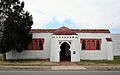
B'Nai Israel Synagogue
-
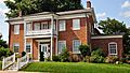
Bennett-Tobler-Pace-Oliver House
-
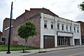
Broadway Theatre
-
Broadway and North Fountain Street Historic District
-
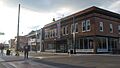
Broadway-Middle Commercial Historic District
-
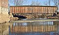
Burfordville Covered Bridge
-
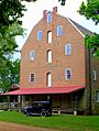
Burfordville Mill
-
Abraham Byrd House
-
Cape Girardeau Commercial Historic District
-

Cape Girardeau Court of Common Pleas
-
Central High School
-
George Boardman Clark House
-
Courthouse-Seminary Neighborhood Historic District
-
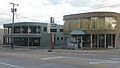
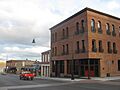
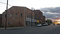
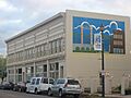
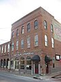
Erlbacher Buildings
-
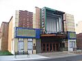
Esquire Theater
-
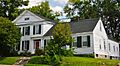
Frizel-Welling House
-
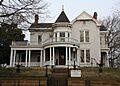
Glenn House
-
Haarig Commercial Historic District
-
Hanover Lutheran Church
-

William Henry and Lilla Luce Harrison House
-
Himmelberger and Harrison Building
-
House at 323 Themis Street
-

Huhn-Harrison House
-
Jackson Uptown Commercial Historic District
-
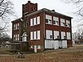
Jefferson School
-
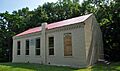
Kage School
-
Klostermann Block
-
Edward S. and Mary Annatoile Albert Lilly House
-
Main-Spanish Commercial Historic District
-
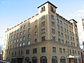
Marquette Hotel
-

McKendree Chapel
-
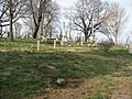
Old Lorimier Cemetery
-
Oliver-Leming House
-
Abraham Russell Ponder House
-
Frederick W. and Mary Karau Pott House
-
James Reynolds House
-
August and Amalia Shivelbine House
-
South Middle Street Historic District
-
Southeast Missourian Building
-
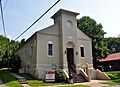
St. James A.M.E. Church
-
St. Vincent De Paul Catholic Church
-
St. Vincent's College Building
-
Colonel George C. Thilenius House
-
Julius Vasterling Building
-
Warehouse Row Historic District
-
Robert Felix and Elma Taylor Wichterich House
-
J. Maple and Grace Senne Wilson House
-
Wood Building


.jpg)


