Burfordville, Missouri facts for kids
Quick facts for kids
Burfordville, Missouri
|
|
|---|---|

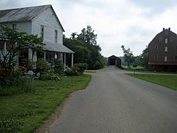
The Bollinger Mill and Burfordville Covered Bridge in 2010
|
|

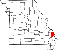
Location of Cape Girardeau, Missouri
|
|
| Country | United States |
| State | Missouri |
| County | Cape Girardeau |
| Township | Kinder Township |
| Area | |
| • Total | 0.34 sq mi (0.87 km2) |
| • Land | 0.34 sq mi (0.87 km2) |
| • Water | 0.00 sq mi (0.00 km2) |
| Elevation | 404 ft (123 m) |
| Population
(2020)
|
|
| • Total | 87 |
| • Density | 259.70/sq mi (100.12/km2) |
| Time zone | UTC-6 (Central (CST)) |
| • Summer (DST) | UTC-5 (CDT) |
| ZIP code |
63739
|
| Area code(s) | 573 |
| FIPS code | 29-09784 |
| GNIS feature ID | 715068 |
Burfordville is a small community in Cape Girardeau County, Missouri, United States. It's not a city, but a small area without its own local government. You can find it on the Whitewater River, about five miles west of Jackson. Burfordville is part of the larger Cape Girardeau-Jackson area.
Two important landmarks in Burfordville are the Bollinger Mill State Historic Site and the Burfordville Covered Bridge. Both of these places are listed on the National Register of Historic Places. This means they are special and protected because of their history.
Contents
What's in a Name?
This community was first known as Bollinger's Mill. This was because George Frederick Bollinger built a mill there. Later, the town was named Burfordville. It got its new name from an early settler in the area, John Burford.
A Look Back: Burfordville's History
The story of Burfordville began with Major George Bollinger. He was an immigrant from Switzerland who came to the area from North Carolina. In 1797, he built the very first mill on the Whitewater River.
Major Bollinger was promised a lot of land if he went back to North Carolina. He needed to convince other families to move to Missouri. So, he returned and brought 20 other Swiss and German immigrant families with him. The village officially became a community in 1900.
Where is Burfordville?
Burfordville is located right on the Whitewater River. It's about eight miles southwest of Jackson. The community is in the central part of Kinder Township.
How Many People Live Here?
According to the 2020 Census, 87 people live in Burfordville.
Learning in Burfordville
Students in Burfordville attend schools in the Jackson R-2 School District. This district also runs Jackson High School.
 | Janet Taylor Pickett |
 | Synthia Saint James |
 | Howardena Pindell |
 | Faith Ringgold |

