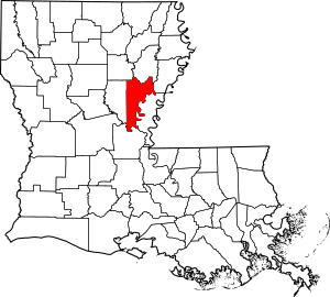
National Register of Historic Places listings in Catahoula Parish, Louisiana facts for kids
This article is about the amazing historic places in Catahoula Parish, Louisiana. These special spots are listed on the National Register of Historic Places. It's like a national list of important buildings, sites, and objects that are worth saving because of their history.
Catahoula Parish has 14 places on this important list. Each one tells a part of Louisiana's past!
What is the National Register of Historic Places?
The National Register of Historic Places is the official list of the United States' historic places. It's part of a program to help people understand and protect important historical sites. When a place is on this list, it means it has special meaning. It could be important for its history, its architecture, or even what it tells us about how people lived long ago.
Historic Places in Catahoula Parish
Catahoula Parish is home to many interesting historic sites. These places include old homes, churches, and even ancient mounds. They help us learn about the past of this area.
Here are some of the places listed on the National Register in Catahoula Parish:
- Battleground Plantation: This historic site is located near Sicily Island. It was added to the list in 1979.
- Caney Mounds: These ancient mounds are found near Jonesville. They became a registered historic place in 2005.
- Catahoula Parish Courthouse: This important building is in Harrisonburg. It was added to the list in 1988.
- Ferry Place: This site is located near Sicily Island. It joined the list in 1980.
- Green-Lovelace House: This old house is north of Sicily Island. It was recognized in 1983.
- Hardin House: Another historic house near Sicily Island, added in 1990.
- Harrisonburg Methodist Church: This church in Harrisonburg became a registered site in 2015.
- Kirby House: Located in Trinity, this house was listed in 1988.
- Marengo Plantation House: This plantation house is west of Jonesville. It was added to the list in 1987.
- Moss Grove Plantation House: Another historic plantation house near Jonesville, listed in 2006.
- Paul's Camp South: This site near Jonesville was added in 2004.
- Sargent House: This house in Harrisonburg was listed in 1980.
- Spring Ridge Baptist Church: This church near Enterprise was recognized in 1993.
- Wildwood: This historic place near Sicily Island joined the list in 1989.
These places are important parts of Catahoula Parish's history. They help us remember and learn about the past.


