
National Register of Historic Places listings in Chatham County, North Carolina facts for kids

Have you ever wondered about the old buildings and places in your town? Many of them have amazing stories! In Chatham County, North Carolina, there are many special spots that are part of the National Register of Historic Places. This is like a special list kept by the United States government. When a place is on this list, it means it's really important to history, architecture, or even how people lived long ago. It helps protect these places so future generations, like you, can learn from them.
You can explore these historic places all over Chatham County, from busy towns like Pittsboro and Siler City to quieter country areas. Each one tells a unique part of North Carolina's past.
Contents
Discovering Chatham County's Historic Treasures
Chatham County is full of interesting places that have been around for a long time. These include old houses, churches, mills, and even whole parts of towns! Let's take a look at some of these cool historic spots.
Historic Homes and Farms: A Glimpse into the Past
Many of the places on the list are old homes and farms. These buildings show us how people lived, worked, and built their lives in Chatham County many years ago.
- Alston-DeGraffenried House: This old house near Pittsboro was listed way back in 1974. It's part of a larger area called the Alston-DeGraffenried Plantation.
- Aspen Hall: Also located west of Pittsboro, Aspen Hall is another historic home that joined the list in 1982.
- Bowen-Jordan Farm: Found near Siler City, this farm was recognized in 1985. Farms like this were the heart of communities long ago.
- Cadmus N. Bray House: This house in Siler City was added to the list in 1999.
- Bray-Paschal House: Another historic home near Siler City, added in 2011.
- Sheriff Stephen Wiley Brewer Farmstead: This farmstead in Pittsboro belonged to a sheriff and was listed in 2003.
- Luther Clegg House: South of Pittsboro, this house was added in 1982.
- DeGraffenreidt-Johnson House: Located near Silk Hope, this house joined the list in 1985.
- Lewis Freeman House: An old house in Pittsboro, recognized in 1982.
- Goodwin Farm Complex: This farm near Bells was listed in 1985.
- Gregson-Hadley House: A historic house in Siler City, added in 1985.
- Hadley House and Grist Mill: Northwest of Pittsboro, this property includes both a house and a grist mill, which was used to grind grain. It was listed in 1980.
- Hall-London House: This house in Pittsboro was added to the list in 1982.
- Haughton-McIver House: Located near Gulf, this house was listed in 1985.
- Marion Jasper Jordan Farm: This farm near Gulf joined the list in 1988.
- Kelvin: An old house in Pittsboro listed in 1982, but sadly, it has since been destroyed.
- London Cottage: North of Pittsboro, this cottage was listed in 1982.
- Henry Adolphus London House: Another London family house in Pittsboro, added in 1998.
- John A. Mason House: Southwest of Durham, this house was listed in 1974.
- McClenahan House: This house in Pittsboro was listed in 1982 and has since been moved to a new spot within the town.
- Robert Joseph Moore House: Located near Bynum, this house was added in 1998.
- Moore-Manning House: A historic house in Pittsboro, listed in 1982.
- Paschal-Womble House: This house in Goldston was recognized in 1984.
- Reid House: An old house in Pittsboro, listed in 1982.
- William Alston Rives House: Located near Goldston, this house was added in 1985.
- Snipes-Fox House: A historic house in Siler City, listed in 1998.
- Patrick St. Lawrence House: This house in Pittsboro was listed in 1982 and has been moved next to the McClenahan House.
- Joseph B. Stone House: Near Farrington, this house was added in 1982.
- William Teague House: A historic house near Siler City, listed in 1985.
- A. P. Terry House: This house in Pittsboro was recognized in 1982.
- James A. Thomas Farm: A farm near Pittsboro, listed in 1985.
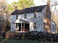
- Dr. E. H. Ward Farm: This 19th-century farm near Bynum belonged to a traveling doctor. It was listed in 1985 and is now used for events.
- Whitehead-Fogleman Farm: Located near Crutchfield Crossroads, this farm was added in 1985.
- Burdett Woody House: This house near Siler City was listed more recently in 2008.
Important Buildings and Structures
Beyond homes, other types of buildings and structures are also important to Chatham County's history.
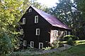
- Baldwin's Mill: This mill near Pittsboro was listed in 1986. Mills were vital for grinding grains and other tasks in early communities.
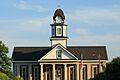
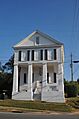
- Chatham County Courthouse: Located in Pittsboro, this courthouse is a very important building for the county's history and government. It was listed in 1979.
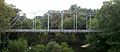
- Deep River Camelback Truss Bridge: This unique bridge over the Deep River, near Cumnock and Gulf, was listed in 1995. Bridges are important for connecting communities.
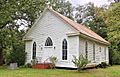
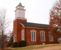
- Ebenezer Methodist Church: This church near Bells was listed in 1985. Churches often serve as important community centers.
- Former High Point Bending and Chair Company: This old factory building in Siler City was listed in 1999. It shows the industrial history of the area.
- Hotel Hadley: This historic hotel in Siler City was added in 1985. Hotels were important places for travelers and community gatherings.
- Lockville Dam, Canal and Powerhouse: West of Moncure, this site includes a dam, canal, and powerhouse, showing how people used rivers for power long ago. It was listed in 1984.
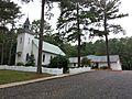
- O'Kelly's Chapel: This chapel near Farrington was listed in 1985.
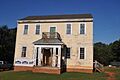
- Pittsboro Masonic Lodge: This lodge in Pittsboro was listed in 1978. Masonic lodges are historic social organizations.
- Pittsboro Presbyterian Church: This church in Pittsboro was added to the list in 1978.
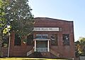
- Siler City City Hall: The city hall in Siler City was listed in 1998.
- Siler City High School: This old high school building in Siler City was recognized in 1998.
Historic Districts: Whole Neighborhoods with Stories
Sometimes, it's not just one building that's historic, but a whole group of buildings or a neighborhood. These are called "historic districts."
- East Raleigh Street Historic District: This district in Siler City includes several blocks of historic buildings and was listed in 2000.
- Goldston Commercial Historic District: This area in Goldston includes historic businesses and was listed in 1987.
- Mount Vernon Springs Historic District: This district near Bonlee was listed in 1987.
- New Hope Rural Historical Archeological District: This area near Wilsonville is important for its historical archaeology, listed in 1985.
- North Third Avenue Historic District: Another historic district in Siler City, listed in 2000.
- Pittsboro Historic District: This large district in Pittsboro includes many historic buildings and was listed in 2000.
- Siler City Commercial Historic District: This district in Siler City includes many historic commercial buildings and was listed in 2000.
Former Listings: Places That Were Once on the List
Sometimes, a place might be removed from the National Register of Historic Places. This can happen for different reasons, like if the building is destroyed or changes too much.
- Ebenezer Log Church: This church near Pittsboro was listed in 1974 but was later removed from the list.
Images for kids
-
Baldwin's Mill
-
Chatham County Courthouse
-
Deep River Camelback Truss Bridge
-
Ebenezer Methodist Church
-
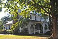
Hall-London House
-
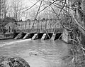
Lockville Dam, Canal and Powerhouse
-
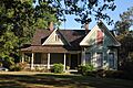
Henry Adolphus London House
-
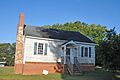
McClenahan House
-
O'Kelly's Chapel
-
Pittsboro Historic District
-
Pittsboro Masonic Lodge
-
Pittsboro Presbyterian Church
-
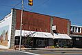
Siler City Commercial Historic District
-
Patrick St. Lawrence House
-
Joseph B. Stone House
-
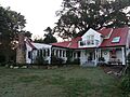
Dr. E. H. Ward Farm


.jpg)


