
National Register of Historic Places listings in Chester County, South Carolina facts for kids
The National Register of Historic Places is like a special list of important places in the United States. These places could be buildings, areas, or even old battlefields that are super important to history, architecture, archaeology, engineering, or culture. When a place is added to this list, it means it's recognized as a valuable part of our past and should be protected for future generations.

In Chester County, South Carolina, there are 20 amazing places and historic districts that have been added to this special list. These sites tell us stories about the people, events, and ways of life that shaped Chester County over many years. Let's explore some of them!
Contents
- Historic Places in Chester County
- Catholic Presbyterian Church
- Chester City Hall and Opera House
- Chester Historic District
- Colvin-Fant-Durham Farm Complex
- Cornwell Inn
- Elliott House
- Fishdam Ford
- Great Falls Depot
- Great Falls Downtown Historic District
- Kumler Hall
- Lando School
- Landsford Canal
- Landsford Plantation House
- Lewis Inn
- McCollum Fish Weir
- McCollum Mound
- People's Free Library of South Carolina
- James Phinney House
- Republic Theater
- Images for kids
Historic Places in Chester County
Catholic Presbyterian Church
The Catholic Presbyterian Church is an old church located about 14 miles south of Chester. It was added to the National Register of Historic Places on May 6, 1971. This church is a great example of the early religious buildings in the area.

Chester City Hall and Opera House
The Chester City Hall and Opera House is a cool building in Chester, found at the corner of West End and Columbia Streets. It was listed on March 30, 1973. This building served as both the city's government center and a place for performances, showing how important culture and community were in the past.

Chester Historic District
The Chester Historic District is not just one building, but a whole area in Chester that has many historic buildings. It's mainly around the junction of U.S. Route 321 and South Carolina Highway 72. This district was first recognized on June 13, 1972, and later expanded in 1988. It's like stepping back in time to see how the town used to look!
,_Chester,_South_Carolina.jpg)
Colvin-Fant-Durham Farm Complex
The Colvin-Fant-Durham Farm Complex is an old farm located west of Chester, near South Carolina Highway 22. It was added to the list on July 30, 1992. This complex helps us understand what farming life was like in the past in Chester County.

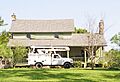
Cornwell Inn
The Cornwell Inn is an historic inn found at the junction of U.S. Route 321 and South Carolina Highway 205 in Blackstock. It became a historic place on February 18, 1994. Inns like this were important stops for travelers in earlier times.

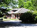
Elliott House
The Elliott House is located north of Richburg. This house was recognized on May 6, 1971. It's an example of the kind of homes built in the area long ago.
Fishdam Ford
Fishdam Ford is a historic site southwest of Chester, off South Carolina Highway 72. It was listed on August 14, 1973. This spot is famous for a battle during the American Revolutionary War, making it a very important historical landmark.

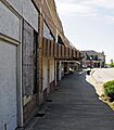
Great Falls Depot
The Great Falls Depot is an old train station on Republic Street in Great Falls. It was added to the National Register on November 25, 1980. Train depots were once busy hubs for travel and trade, connecting towns and people.

Great Falls Downtown Historic District
Similar to Chester, Great Falls also has its own Downtown Historic District, centered around Dearborn Street. This district was listed on June 2, 2000. It preserves the look and feel of the town's historic downtown area.

Kumler Hall
Kumler Hall is a building located at Lancaster and Cemetery Streets in Chester. It was recognized on January 27, 1983. This building has played a role in the history of education or community life in Chester.

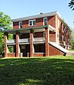
Lando School
The Lando School is an old schoolhouse on Schoolhouse Road in Lando. It was added to the list on July 1, 2009. Old school buildings like this one remind us of how education has changed over the years.

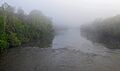
Landsford Canal
The Landsford Canal is an amazing engineering feat located off U.S. Route 21 near Rowell. It was listed on December 3, 1969. Canals were built to help boats travel around difficult parts of rivers, making trade and transportation easier.

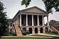
Landsford Plantation House
The Landsford Plantation House is a historic home near Richburg, about half a mile east of U.S. Route 21. It was recognized on February 4, 1987. Plantation houses are important for understanding the history of agriculture and society in the region.

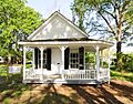
Lewis Inn
The Lewis Inn is another historic inn, located northeast of Chester off South Carolina Highway 72. It was added to the National Register on May 6, 1971. Just like the Cornwell Inn, it tells us about early travel and hospitality.

McCollum Fish Weir
The McCollum Fish Weir is a unique historical site near Lockhart. It was listed on August 28, 1974. A fish weir is an ancient structure used to catch fish, showing us how people lived and gathered food long ago.

McCollum Mound
The McCollum Mound, also known as "Turkey Creek Mound," is located where the Broad River meets Turkey Creek, near Chester. It was recognized on March 23, 1972. Mounds like this are often ancient Native American sites, providing clues about early cultures.
People's Free Library of South Carolina
The People's Free Library of South Carolina is on Church Street in Lowrys. It was added to the National Register on October 29, 1982. This library is important because it represents the history of public access to books and learning in the state.

James Phinney House
The James Phinney House is located at 2762 Blaney Road, in the area around Chester. It was added to the list more recently, on October 11, 2016. This house is a good example of historic homes in the Chester vicinity.
Republic Theater
The Republic Theater is at 806 Dearborn Street in Great Falls. It was recognized on November 26, 1980. Theaters like the Republic were once central to entertainment and community gatherings, showing movies and live performances.

Images for kids
-
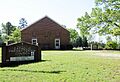
The historic Catholic Presbyterian Church.
-
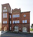
Chester City Hall and Opera House.
-
The Chester County Courthouse, part of the Chester Historic District.
-
A building at the Colvin-Fant-Durham Farm Complex.
-
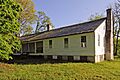
The Cornwell Inn.
-
Fishdam Ford, a historic battle site.
-
The Great Falls Depot.
-
A view of the Great Falls Historic District.
-
Kumler Hall.
-
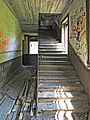
Inside the Lando Schoolhouse.
-
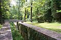
A stone lock at Landsford Canal.
-
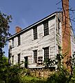
The Landsford Plantation House.
-
The Lewis Inn.
-

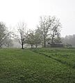
Image representing a site with restricted address.
-
The People's Free Library.
-
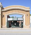
The Republic Theater.
