
National Register of Historic Places listings in Christian County, Kentucky facts for kids

Have you ever wondered about the oldest and most special buildings or places in your town? In Christian County, Kentucky, there are many such places! They are so important that they are listed on the National Register of Historic Places. This is like a special list kept by the U.S. government to protect and celebrate buildings, sites, and objects that have a lot of history or special meaning.
When a place is added to this list, it means it's recognized as a significant part of American history. It helps people learn about the past and encourages communities to take care of these treasures. Christian County has 49 different places on this list, from old schools and churches to historic homes and even entire neighborhoods! Let's explore some of them.
Contents
What is the National Register of Historic Places?
The National Register of Historic Places is the official list of the nation's historic places worth saving. It's part of a program to coordinate and support public and private efforts to identify, evaluate, and protect America's historic and archaeological resources.
Why are places listed?
Places are listed for many reasons. They might be important because of their unique architecture, or because famous people lived there. Some places are important because they were part of big events in history. Others show how people lived long ago. Being on the list helps preserve these places for future generations.
Historic Places in Hopkinsville
Many of Christian County's historic places are found in its largest city, Hopkinsville. This city has a rich history, and its buildings tell many stories.
Historic Neighborhoods and Districts
Hopkinsville has several areas where many historic buildings are grouped together. These are called "historic districts."
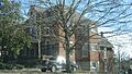
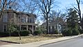
- Alumni-Latham-Mooreland Historic District: This area includes streets like Alumni Avenue, Latham Avenue, and Mooreland Drive. It was added to the list in 1993. Walking through this district is like taking a step back in time, seeing how neighborhoods looked many years ago.
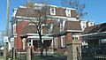
- East 7th Street Historic District: This district is roughly along East 7th Street. It was recognized in 1983. It's another great example of how historic homes and buildings create a special atmosphere in a part of the city.
- Hopkinsville Commercial Historic District: This district covers the downtown business area of Hopkinsville. It was listed in 1979. It shows how the city's businesses and shops developed over time. The Christian County courthouse is a notable building in this district.
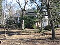
- Hopkinsville Residential Historic District: This larger district includes many homes between 14th and 20th Streets, and Main and Virginia Streets. It was also added in 1979. It's a wonderful place to see different styles of old houses.
- Hopkinsville Warehouse Historic District: This area along Harrison Street and the railroad tracks was important for storing goods. It was listed in 1979. It reminds us of how goods were transported and traded in the past.
Important Buildings in Hopkinsville
Many individual buildings in Hopkinsville are also on the National Register.
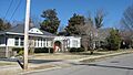
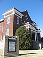
- Attucks High School: Located at 712 East 1st Street, this school was added to the list in 2013. It's an important landmark in the history of education in Hopkinsville.
- Confederate Memorial Fountain in Hopkinsville: This fountain, located north of the junction of U.S. Route 41 and Main Street, was listed in 1997. It's a monument that tells a part of the local history.
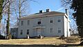
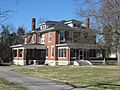
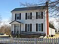
- Judge Joseph Crockett House: Found at 317 East 16th Street, this house was recognized in 1979. It was once the home of Judge Joseph Crockett, an important person in the community.
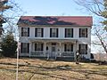
- Monroe Dalton House: This house at 713 East 7th Street was listed in 1983. It's a beautiful example of historic architecture.
- Fairelond: Located at 1303 East 7th Street, Fairelond was added to the list in 1983. It's another significant historic home.
- Freeman Chapel C.M.E. Church: This church at 137 South Virginia Street was listed in 1983. Churches often play a big role in a community's history and culture.
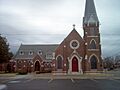
- Grace Episcopal Church: At 220 East 6th Street, this church was recognized in 1982. It's known for its beautiful design and long history.
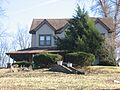
- E.H. Higgins House: This house at 1530 East 7th Street was added in 1984. It's another example of the historic homes in Hopkinsville.
- Hopkinsville L & N Railroad Depot: Located at 425 East 9th Street, this old train station was listed in 1975. Train depots were once very busy places, connecting towns and people.
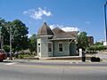
- Hopper Court: This unique court was listed in 1979. It's a reminder of different types of housing and community layouts from the past.
- J.B. Knight House: At 1417 East 7th Street, this house was added in 1979. It's part of the rich collection of historic homes in the city.
- Latham Confederate Monument: This monument is in Riverside Cemetery, west of Hopkinsville. It was listed in 1997. Like the fountain, it's a historical marker.
- Poston House: Located at 809 Hayes Street, the Poston House was listed in 1979. It's another example of a well-preserved historic home.
- Dr. Edward S. Stewart House: This house is on U.S. Route 68 in Fairview, near Hopkinsville. It was listed in 1979.
- E.W. Walker House: At 1414 East 7th Street, this house was added in 1983. It contributes to the historic feel of the East 7th Street area.
- Western State Hospital: Located on U.S. Route 68, this historic hospital was listed in 1979. It has a long and important history in healthcare for the region.
- Frank K. Yost House: This house at 1131 East 7th Street was listed in 1983. It's another significant building in the East 7th Street Historic District.
Other Historic Sites in Christian County
Beyond Hopkinsville, Christian County has other interesting places on the National Register.
- Cedar Grove: East of Oak Grove, this site was listed in 1977. It's a historic property that tells a story of the county's past.
- Church Hill Grange Hall: About 5.5 miles southwest of Hopkinsville on Cox Mill Road, this hall was listed in 1975. Grange halls were important community centers for farmers.
- Lafayette Methodist Church: Located off Kentucky Route 107 in LaFayette, this church was listed in 1979. It's a historic place of worship for the community.
- McRay Site (15CH139) and Pilot Rock Petroglyphs (15CH200): These sites are "address restricted," meaning their exact location is kept private to protect them. They are important archaeological sites, possibly containing ancient carvings or remains that teach us about early human history in the area.
These are just some of the many fascinating places in Christian County that are recognized for their historical importance. Each one helps us understand the rich story of Kentucky and the United States.
Images for kids
-
A view of Alumni Avenue in the Alumni-Latham-Mooreland Historic District.
-
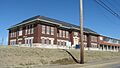
Attucks High School in Hopkinsville.
-
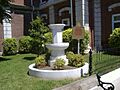
The Confederate Memorial Fountain in Hopkinsville.
-
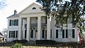
The Judge Joseph Crockett House.
-
The Monroe Dalton House.
-
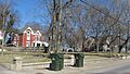
A street view in the East 7th Street Historic District.
-
The historic Fairelond house.
-
Freeman Chapel C.M.E. Church.
-
Grace Episcopal Church.
-
The E.H. Higgins House.
-
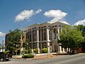
The Christian County Courthouse, part of the Commercial Historic District.
-
The Hopkinsville L & N Railroad Depot.
-
A street in the Hopkinsville Residential Historic District.
-
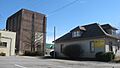
A view in the Hopkinsville Warehouse Historic District.
-
Hopper Court.
-
The J.B. Knight House.
-
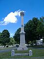
The Latham Confederate Monument.
-

The Poston House.
-
The Dr. Edward S. Stewart House.
-
The E.W. Walker House.
-

Western State Hospital.
-
The Frank K. Yost House.


.jpg)


