Oak Grove, Kentucky facts for kids
Quick facts for kids
Oak Grove, Kentucky
|
|
|---|---|
| Motto(s):
"Kentucky's Rising Star on the Border"
|
|

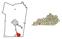
Location of Oak Grove in Christian County, Kentucky
|
|
| Country | United States |
| State | Kentucky |
| County | Christian |
| Incorporated | 1974 |
| Area | |
| • Total | 10.74 sq mi (27.82 km2) |
| • Land | 10.71 sq mi (27.74 km2) |
| • Water | 0.03 sq mi (0.08 km2) |
| Elevation | 541 ft (165 m) |
| Population
(2020)
|
|
| • Total | 7,931 |
| • Estimate
(2022)
|
7,997 |
| • Density | 740.59/sq mi (285.94/km2) |
| Time zone | UTC-6 (Central (CST)) |
| • Summer (DST) | UTC-5 (CDT) |
| ZIP code |
42262
|
| Area code(s) | 270 & 364 |
| FIPS code | 21-57090 |
| GNIS feature ID | 0499655 |
Oak Grove is a city in Kentucky, United States. It's right next to Fort Campbell, a big U.S. Army base. Oak Grove is located in Christian County.
In 2020, about 7,931 people lived there. This was more than the 7,489 people who lived there in 2010. Oak Grove is also part of the larger Clarksville, Tennessee area.
Contents
History of Oak Grove
Early Days and Name
The first post office in Oak Grove opened in 1828. The community got its name from the many oak trees that grew near where the town first started. Later, in the 1800s, the Clarksville Railroad was extended to reach Oak Grove.
Growth with Fort Campbell
During World War II, a large army base called Fort Campbell was built nearby. This led to a big increase in the number of people living in Oak Grove. The city officially became an incorporated city (meaning it got its own local government) on September 24, 1974. This was decided by the state legislature of Kentucky.
Where is Oak Grove?
Location and Borders
Oak Grove is located in the southeastern part of Christian County. Its southern border is the state line with Tennessee. To the west, it shares a border with Fort Campbell.
The city of Hopkinsville, which is the main city in Christian County, touches the northwest corner of Oak Grove. This happens along a road called Fort Campbell Boulevard, which is also known as U.S. Route 41 Alternate.
Major Roads and Nearby Cities
Interstate 24, a major highway, forms the northeast edge of Oak Grove. You can get to Oak Grove from this highway at exit 86 (US 41 Alt.) and exit 89 (Kentucky Route 115). The city of Clarksville, Tennessee, is also located right along Oak Grove's southern border.
Size of the City
The United States Census Bureau says that Oak Grove covers a total area of about 10.8 square miles (27.9 km2). Only a very small part of this area, about 0.03 square miles (0.09 km2), is water.
People of Oak Grove
Population Overview
In the year 2000, there were 7,064 people living in Oak Grove. These people lived in 2,529 households, and 1,820 of these were families.
The population density was about 685.4 inhabitants per square mile (264.6/km2). This means there were about 685 people for every square mile. There were also 2,912 homes or housing units in the city.
Population Changes Over Time
The number of people living in Oak Grove has changed over the years:
| Historical population | |||
|---|---|---|---|
| Census | Pop. | %± | |
| 1980 | 2,088 | — | |
| 1990 | 2,863 | 37.1% | |
| 2000 | 7,064 | 146.7% | |
| 2010 | 7,489 | 6.0% | |
| 2020 | 7,931 | 5.9% | |
| 2022 (est.) | 7,997 | 6.8% | |
| U.S. Decennial Census | |||
Age Groups
In 2000, the people in Oak Grove were of different ages:
- 32.2% were under 18 years old.
- 23.4% were between 18 and 24 years old.
- 38.6% were between 25 and 44 years old.
- 4.9% were between 45 and 64 years old.
- 1.0% were 65 years old or older.
The average age of people in Oak Grove was 24 years.
Climate in Oak Grove
The weather in Oak Grove has hot and humid summers. The winters are usually mild to cool. This type of weather is called a humid subtropical climate. On climate maps, you might see this type of climate labeled as "Cfa".
See also
 In Spanish: Oak Grove (Kentucky) para niños
 | Aurelia Browder |
 | Nannie Helen Burroughs |
 | Michelle Alexander |

