LaFayette, Kentucky facts for kids
Quick facts for kids
LaFayette, Kentucky
|
|
|---|---|

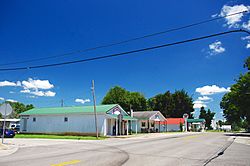
KY 107 in LaFayette
|
|

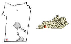
Location of LaFayette in Christian County, Kentucky.
|
|
| Country | United States |
| State | Kentucky |
| County | Christian |
| Incorporated | 1836 |
| Area | |
| • Total | 0.26 sq mi (0.67 km2) |
| • Land | 0.26 sq mi (0.67 km2) |
| • Water | 0.00 sq mi (0.00 km2) |
| Elevation | 597 ft (182 m) |
| Population
(2020)
|
|
| • Total | 177 |
| • Density | 686.05/sq mi (264.97/km2) |
| Time zone | UTC-6 (Central (CST)) |
| • Summer (DST) | UTC-5 (CDT) |
| ZIP code |
42254
|
| Area code(s) | 270 & 364 |
| FIPS code | 21-43444 |
| GNIS feature ID | 0508413 |
LaFayette is a small city in Christian County, Kentucky, in the United States. It is also sometimes spelled La Fayette or Lafayette. In 2020, about 177 people lived there. This was a small increase from 165 people in 2010. LaFayette is part of the larger Clarksville, Tennessee metropolitan area.
Contents
History of LaFayette
LaFayette was first settled in the late 1810s. By 1820, it already had a store selling dry goods and groceries. The state government of Kentucky officially made it a city in 1836.
Naming the City
The city got its name from the Marquis de Lafayette. He was a French hero who helped America during the American Revolutionary War.
Historic Church Building
LaFayette is home to the Lafayette Methodist Church. This old church was built in 1852 by Daniel Umbenhour, who was from the Netherlands. Today, the church is listed on the National Register of Historic Places. This means it is an important historical site.
Geography of LaFayette
LaFayette is located in the southwestern part of Christian County. It is found along Kentucky Route 107. The city is about 18 miles (29 km) southwest of Hopkinsville. Hopkinsville is the main town and county seat of Christian County. LaFayette is also only about 2 miles (3 km) north of the Tennessee state line. The large US Army base, Fort Campbell, is just south of the town.
Land Area
According to the United States Census Bureau, LaFayette covers a total area of about 0.26 square miles (0.67 km2). All of this area is land.
Population Changes in LaFayette
The number of people living in LaFayette has changed over the years. Here is a look at the population counts from different years:
| Historical population | |||
|---|---|---|---|
| Census | Pop. | %± | |
| 1870 | 215 | — | |
| 1880 | 970 | 351.2% | |
| 1890 | 215 | −77.8% | |
| 1900 | 199 | −7.4% | |
| 1910 | 266 | 33.7% | |
| 1920 | 307 | 15.4% | |
| 1930 | 227 | −26.1% | |
| 1940 | 229 | 0.9% | |
| 1950 | 246 | 7.4% | |
| 1960 | 196 | −20.3% | |
| 1970 | 158 | −19.4% | |
| 1980 | 160 | 1.3% | |
| 1990 | 106 | −33.7% | |
| 2000 | 193 | 82.1% | |
| 2010 | 165 | −14.5% | |
| 2020 | 177 | 7.3% | |
| U.S. Decennial Census | |||
Life in LaFayette (2000 Census)
In the year 2000, there were 193 people living in LaFayette. These people lived in 75 households, and 51 of these were families. The average household had about 2.57 people. The average family had about 3.22 people.
About 29% of the people were under 18 years old. Around 9% of the population was 65 years old or older. The median age in the town was 33 years.
See also
 In Spanish: LaFayette (Kentucky) para niños
 | Mary Eliza Mahoney |
 | Susie King Taylor |
 | Ida Gray |
 | Eliza Ann Grier |

