
National Register of Historic Places listings in Collin County, Texas facts for kids

Collin County, Texas, is home to many amazing places that tell stories about the past! These special spots are listed on the National Register of Historic Places. This is like a national scrapbook of important buildings, areas, and sites that have played a big part in American history. When a place is on this list, it means it's recognized for its unique history or architecture. It also helps protect these places for future generations to enjoy and learn from.
Contents
What is the National Register of Historic Places?
The National Register of Historic Places is the official list of the nation's historic places worth saving. It's managed by the National Park Service. Being on the list doesn't stop people from changing their property, but it encourages them to preserve it. It also makes these places eligible for certain benefits, like grants or tax breaks, to help with their upkeep.
Types of Historic Places You Can Find
Collin County has a wide variety of historic places. They include old homes, schools, businesses, and even parts of old railway lines. Each one has a unique story about how people lived, worked, and built communities in the past.
Historic Homes and Buildings
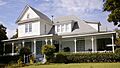
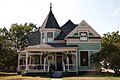
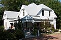
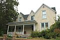
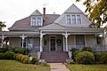
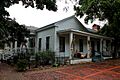
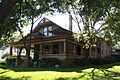
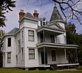
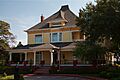
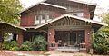
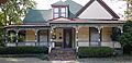
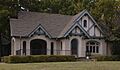
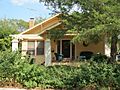
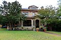
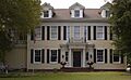
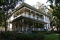
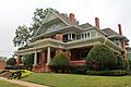
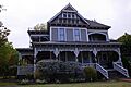
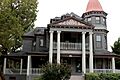
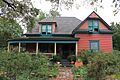
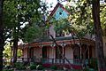
Many of the places on the list are beautiful old houses. These homes show us how people lived long ago and what kind of architecture was popular. For example, in McKinney, you can find many historic houses like the Beverly-Harris House and the John H. Bingham House. These homes often have special designs and details that were common many years ago. They remind us of the families who lived there and the history they created.
Schools and Public Buildings
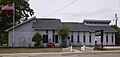
Some historic places are buildings that served the whole community. The Celina Public School in Celina is one such example. Old schools are important because they show how education has changed over time. They also represent the growth of a town and its commitment to learning. These buildings often have unique architectural styles that were popular when they were built.
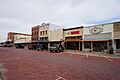
Important Business Places
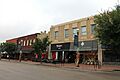
Businesses have always been a big part of how towns grow. In Farmersville, the Aston Building and the Farmersville Commercial Historic District are on the list. These places show us what downtown areas looked like when they were first built. They tell stories of shops, offices, and community life. The Farmersville Masonic Lodge No. 214 is another historic building. It was a meeting place for a community group.
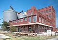
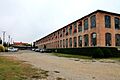
McKinney also has important business history. The Collin County Mill and Elevator Company and the Hill-Webb Grain Elevator show how agriculture was a major industry. These buildings were vital for processing and storing crops. The McKinney Cotton Compress Plant and the McKinney Cotton Mill Historic District highlight the importance of cotton in the region's economy. These sites tell us about the hard work and industries that shaped Collin County.
Train Stations and Railways
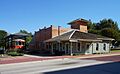
Railroads were super important for connecting towns and moving goods and people. The Allen Water Station in Allen is a historic spot related to trains. It was likely used to refill steam locomotives with water. In Plano, the Plano Station, Texas Electric Railway is another key historic railway site. It was part of an electric interurban railway system. This system connected cities before cars became common. The Fairview H&TC Railroad Historic District also marks an important part of the old Houston & Texas Central Railroad tracks. These sites help us understand how transportation developed in Texas.
Why Are These Places Important?
These historic places are more than just old buildings. They are like open-air museums that teach us about the past. They show us how people lived, worked, and built communities. By preserving them, we keep our history alive. We also make sure that future generations can learn from the stories these places tell. They help us understand where we came from and how our towns grew into what they are today.
Images for kids
-

Allen Water Station
-
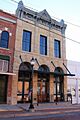
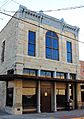
Aston Building
-

Beverly-Harris House
-

John H. Bingham House
-

Board-Everett House
-

John R. Brown House
-
Burrus-Finch House
-
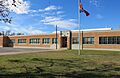
Celina Public School
-
U. P. Clardy House
-
Cline-Bass House
-

J. R. Coggins House
-
Collin County Mill and Elevator Company
-
Crouch-Perkins House
-

H. L. Davis House
-
Davis-Hill House
-
J. S. Dowell House
-

Joe E. Dulaney House
-

Joseph Field Dulaney House
-
Estes House
-

F. C. Faires House
-
Faires-Bell House
-
Farmersville Commercial Historic District
-
Farmersville Masonic Lodge No. 214, A.F. and A.M.
-
John H. Ferguson House
-

Foote-Crouch House
-

S. H. Fox House
-

Jim B. Goodner House
-
Gough-Hughston House
-
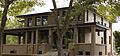
Heard-Craig House
-
Ben Hill House
-
John B. Hill House
-
Moran Hill House
-

W. R. Hill House
-

Hill-Webb Grain Elevator
-

House at 1303 W. Louisiana
-
House at 201 N. Graves
-

House at 704 Parker
-
Houses at 406 and 408 Heard
-

John Johnson House
-

Thomas Johnson House
-
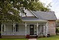
Mrs. J. C. King House
-

E. W. Kirkpatrick House and Barn
-
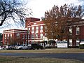
McKinney Commercial Historic District
-

McKinney Cotton Compress Plant
-
McKinney Cotton Mill Historic District
-
Old McKinney Hospital
-
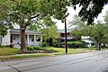
McKinney Residential Historic District
-
Sam Neathery House
-
J. P. Nenney House
-

R. F. Newsome House
-
Newsome-King House
-
Plano Station, Texas Electric Railway
-
John C. Rhea House
-

A. M. Scott House
-
L. A. Scott House
-

J. H. Taylor House
-
Thompson House
-

R. L. Waddill House
-

Thomas W. Wiley House
-
A. G. Wilson House
-
Ammie Wilson House


.jpg)


.jpg)


Former Listings
Sometimes, a historic place might be removed from the National Register. This can happen if the building is destroyed or if it loses its historic importance. One example of a place formerly listed in Collin County is the Collin McKinney Cabin. It was once located in Finch Park in McKinney.
