
National Register of Historic Places listings in Coshocton County, Ohio facts for kids

Welcome to Coshocton County, Ohio! This area is home to many special places that are part of the National Register of Historic Places. The National Register is like a special list kept by the United States government. It helps to identify and protect important buildings, sites, and objects that have a lot of history or are very special in some way.
When a place is on this list, it means it's recognized for its historical, architectural, or archaeological importance. It helps people remember and learn about the past. In Coshocton County, there are 20 amazing places currently on this list. There was also one other place that was listed but later moved and is now on a different list. Let's explore some of these cool historic spots!
Contents
Discovering Coshocton County's Historic Places
Homes and Buildings with Stories
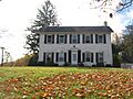
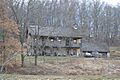
- Adams-Gray House: Located southeast of Trinway in Virginia Township, this historic house was added to the Register on December 5, 1979. It even extends into a neighboring county!
- Chalfant Church: You can find this church south of Warsaw in Washington Township. It became a historic site on March 15, 1982.
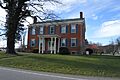
- Coshocton County Courthouse: This important building in Coshocton city, located on Courthouse Square, was recognized on May 22, 1973. It's where many local government decisions are made.
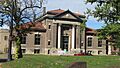
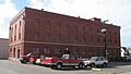
- Eldridge-Higgins Building: Found at 525 Orange Street in Coshocton, this building joined the Register on August 6, 1998.
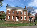
- Andrew Ferguson House: East of West Lafayette in Lafayette Township, this house became a historic landmark on November 30, 1978.
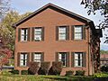
- Thomas Johnson House: In Plainfield, this house on State Route 541 was added to the list on May 14, 1982.
- Johnson-Humrickhouse House: Located at 302 South 3rd Street in Coshocton, this house has been recognized since October 9, 1974.
- Lamberson-Markley Houses: These houses at 713 Main Street in Canal Lewisville, part of Tuscarawas Township, were added on October 18, 1984.
- Samuel Lee House: At 306 4th Street in Coshocton, this house was listed on December 6, 1979.
- J.F. Meek Buildings: These buildings at 546 Chestnut Street and 213-215 North 6th Street in Coshocton were added on January 2, 1985.
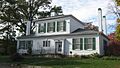
- Daniel Miller House: West of West Lafayette in Lafayette Township, this house at 52357 County Road 16 became historic on January 3, 1980.
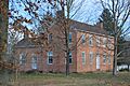
- Cuthbert Milligan House: North of Coshocton in Keene Township, this house was recognized on November 25, 1980.
- Old Union School: This former school building at 310 Sycamore Street in Coshocton was added to the Register on October 18, 1984. It's a reminder of how schools used to look!
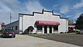
- Warsaw Hotel: Located at 102 East Main Street in Warsaw, this historic hotel was listed on March 17, 1994.
Historic Districts and Structures
- Coshocton Main Street Historic District: This important area in Coshocton, including parts of Main, Chestnut, and Walnut Streets, was added on February 28, 2019. It protects a whole section of historic buildings.
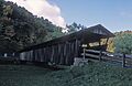
- Helmick Covered Bridge: East of Blissfield in Clark Township, this charming covered bridge on Township Road 25 was listed on June 18, 1975. Covered bridges are a cool part of history!
- Muskingum River Navigation Historic District: This large district covers parts of Coshocton and other counties. It was recognized on February 9, 2007, for its importance in river travel and trade.
- Eli Nichols Farm: West of Walhonding in Newcastle Township, this farm was added to the Register on November 29, 1982.
- Roscoe Village: This entire village in Coshocton, especially Whitewoman and High Streets, became a historic district on April 3, 1973. It's like stepping back in time!
- Walhonding Canal Lock No. 9: West of Warsaw in Jefferson Township on State Route 715, this canal lock was listed on February 24, 1986. Canals were once super important for moving goods.
A Historic Place That Moved
Sometimes, a historic place might change its location or status.
- Rodrick Bridge: This bridge was once listed on the Register on November 29, 1978. It was located southeast of Coshocton. However, in 1997, the bridge was moved to the Ohio State University-Newark campus. Because it moved, it was removed from the Coshocton County list on April 10, 1998. It was then relisted in Licking County in 1998, where it stands today!
Images for kids
-
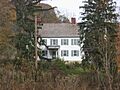
The historic Adams-Gray House.
-
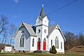
The Chalfant Church, a historic landmark.
-
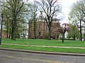
The Coshocton County Courthouse.
-
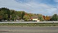
A building within the Coshocton Main Street Historic District.
-
The Eldridge-Higgins Building.
-
The Andrew Ferguson House.
-
The Helmick Covered Bridge.
-
The Thomas Johnson House in Plainfield.
-
The Johnson-Humrickhouse House.
-
One of the Lamberson-Markley Houses.
-

The Samuel Lee House, now Parkview North Apartments.
-
The J.F. Meek Building.
-
The Daniel Miller House.
-
The Cuthbert Milligan House.
-
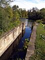
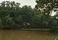
Locks along the Muskingum River, part of the historic navigation district.
-
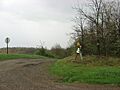
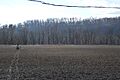
The driveway leading to the Eli Nichols Farm.
-
The Old Union School building.
-
A view of Roscoe Village.
-
Walhonding Canal Lock No. 9.
-
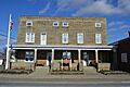
The historic Warsaw Hotel.
-
The Rodrick Bridge before it was moved.


.jpg)
See also
- List of National Historic Landmarks in Ohio
- Listings in neighboring counties: Guernsey, Holmes, Knox, Licking, Muskingum, Tuscarawas
- National Register of Historic Places listings in Ohio
