
National Register of Historic Places listings in Davison County, South Dakota facts for kids

This page lists special places in Davison County, South Dakota, United States, that are recognized for their history. These places are part of the National Register of Historic Places. This is a list of important buildings, sites, and districts that are worth preserving because of their historical or architectural value.
You can see where these places are on a map if their exact location (latitude and longitude) is shared. In Davison County, there are 26 places listed on the National Register. One of these is even more special: it's a National Historic Landmark, which means it's a very important historical site for the entire country!
Contents
What is the National Register of Historic Places?
The National Register of Historic Places is like a special list kept by the United States government. It helps protect buildings, structures, objects, sites, and districts that are important in American history, architecture, archaeology, engineering, or culture. When a place is added to this list, it means it's recognized as a valuable part of our past.
Why are places listed?
Places get listed for many reasons. Maybe a famous person lived there, or an important event happened there. Sometimes, a building is listed because it's a great example of a certain type of architecture, like an old church or a unique house. Being on the list encourages people to take care of these historic spots.
Historic Places in Davison County
Davison County has many interesting places on the National Register. Let's explore some of them!
Mitchell Site: A National Historic Landmark
The most important historical site in Davison County is the Mitchell Site. This amazing place is an archaeological site. It shows us where a very old village once stood, built by people from the Mississippian culture long, long ago. It's like a window into the past, helping us understand how people lived before modern times.
- Location: 3200 Indian Village Road, Mitchell
- What it is: An ancient village site from a prehistoric culture.
- Why it's special: It's a National Historic Landmark, meaning it's one of the most important historical sites in the entire country. You can even visit it!
Dakota Wesleyan University
Dakota Wesleyan University is a historic college campus in Mitchell. It has been an important place for education in South Dakota for many years. The buildings on campus show different styles of architecture from when they were built.
- Location: Bounded by E. and W. University Aves. and McCabe St., Mitchell
- What it is: A historic university campus.
- Why it's special: It represents a long history of education and community in the area.
Mitchell Historic Commercial District
The Mitchell Historic Commercial District includes many old buildings in the downtown area of Mitchell. These buildings were once busy shops, offices, and businesses. Walking through this district is like stepping back in time to see what the city looked like in its early days.
- Location: Main Street and surrounding blocks in Mitchell.
- What it is: A collection of historic business buildings.
- Why it's special: It shows the growth and development of Mitchell's downtown area.
Historic Homes and Buildings
Many individual homes and buildings in Davison County are also on the National Register. These include:
- John F. Anderson House: A historic home located at 323 N. Duff in Mitchell.
- Whittier and Virginia Bauer House: Another interesting house at 600 E. 4th Ave. in Mitchell.
- Louis Beckwith House: Found at 1311 S. Duff Dr. in Mitchell.
- E. B. Bobb House: Located at 501 E. 4th St. in Mitchell.
- C. E. Chambers House: A historic residence at 322 W. 11th St. in Mitchell.
- W. S. Hill House: This house is at 520 East 6th Avenue in Mitchell.
- Kibbee-Nepstad House: Located at 409 E. 5th Ave. in Mitchell.
- Koch Apartments: An apartment building at 209 W. 2nd Ave. in Mitchell.
- William Koch House: A house at 201 W. 2nd St. in Mitchell.
- L.J. Welch House: Found at 608 E. 4th Ave. in Mitchell.
- Whittier School: A historic school building at 410 W. 2nd Ave. in Mitchell.
These homes and buildings often show unique architectural styles or were owned by important people in the community's history.
Other Notable Listings
- Holy Family Church, School, and Rectory: This group of buildings at Kimball and Davison Sts. in Mitchell is important for its religious and community history.
- Mitchell Lustron Historic District: This district features special homes called Lustron houses. These were unique, prefabricated steel homes built after World War II.
- Mitchell West Central Residential Historic District: This area includes many historic homes that show how Mitchell grew as a city.
- Ellis and Roberta Henline Farmstead: This historic farm near Mount Vernon shows what rural life was like in the past.
- South Dakota Dept. of Transportation Bridges: Several old bridges over creeks like Enemy Creek, Twelve Mile Creek, and Firesteel Creek are also listed. These bridges are important examples of early engineering.
Former Listings
Sometimes, a place might be removed from the National Register of Historic Places. This can happen if the building is changed too much, or if it is unfortunately torn down. One such example in Davison County was:
- South Dakota Dept. of Transportation Bridge No. 18-142-150: This bridge over Enemy Creek near Mitchell was listed in 1993 but was later removed from the list in 1999.
Images for kids
-
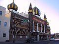
The Mitchell Corn Palace, located within the Mitchell Historic Commercial District.
-
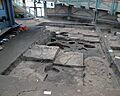
The Thomson Archeodome Research Center at the Mitchell Site.


