
National Register of Historic Places listings in DeSoto Parish, Louisiana facts for kids

DeSoto Parish in Louisiana is home to many amazing places that are super old and important! These special spots are listed on something called the National Register of Historic Places. Think of it like a national "Hall of Fame" for buildings, sites, and objects that tell important stories about America's past.
When a place is added to this list, it means it's recognized as a valuable part of history. It helps protect these places so future generations, like you, can learn from them. DeSoto Parish has about 29 of these cool historic places. Let's explore some of them!
Contents
What is the National Register of Historic Places?
The National Register of Historic Places is the official list of the United States' historic places worth saving. It's managed by the National Park Service. When a building, a whole neighborhood, or even a battlefield is put on this list, it means it has special historical, architectural, or archaeological importance.
Being on the list encourages people to protect these sites. It also helps people learn about the past and how different places shaped our country.
Historic Buildings and Homes
DeSoto Parish has many old houses and buildings that are like time capsules! They show us how people lived long ago.
Mansfield's Important Buildings
The town of Mansfield is the main city in DeSoto Parish. It has several buildings on the National Register:
- DeSoto Parish Courthouse: This is where important decisions for the parish are made. It's a grand building that has stood for many years.
- Kansas City Southern Depot: This old train station was once a busy place where people traveled and goods were shipped. It reminds us of a time before cars were everywhere.
- U.S. Post Office: Even the old post office in Mansfield is historic! It shows how communities communicated in the past.
- Mansfield Historic District: This isn't just one building, but a whole area around the courthouse. It includes many old buildings that together tell the story of downtown Mansfield.
Grand Cane's Charm
The small town of Grand Cane also has its share of historic gems:
- Bank of Grand Cane: This old bank building shows us what financial places looked like in earlier times.
- Grand Cane Historic District: Similar to Mansfield, this district includes a group of historic buildings in Grand Cane. It helps preserve the town's unique old-time feel.
- Grand Cane United Methodist Church: Churches often play a big role in a community's history, and this one is a great example.
Keachi's Historic Spots
The village of Keachi is another place rich in history, with many listed properties:
- Allen House: An old home that gives us a peek into how families lived in the past.
- Keachi Baptist Church: Another historic church, showing the importance of faith in the community's development.
- Keachi Presbyterian Church: This beautiful church, built a long time ago, is a landmark in Keachi.
- Keachi Store: Old stores were often the heart of a community, where people gathered and bought supplies.
- Keachi United Methodist Church: Yet another historic church in Keachi, showing its strong community roots.
- Liberty Lodge No. 123, F&AM: This building belonged to a fraternal organization, which were popular social groups in the past.
- The Oaks: Another historic house that tells a story of the people who lived there.
- Prude House: An old home that adds to the historic character of Keachi.
- Spell House: This house is also a part of Keachi's rich architectural history.
- Swearingen House: One more historic home that helps preserve the look and feel of old Keachi.
Plantation Homes
DeSoto Parish was once home to many large farms called plantations. Some of their main houses are still standing and are on the list:
- Buena Vista: A historic home near Stonewall.
- Land's End Plantation: Located southeast of Stonewall, this old plantation house has a long history.
- Myrtle Hill Plantation House: Found near Gloster, this house is a reminder of the area's agricultural past.
- Roseneath: Another historic plantation house near Gloster.
- Thomas Scott House: Also near Gloster, this house is an important part of the region's history.
Schools for the Community
Education has always been important, and some old school buildings are now protected:
- Community Rosenwald School: This school in Grand Cane was part of a special program that built schools for African American children in the early 20th century.
- Longstreet Rosenwald School: Another Rosenwald school, located in Longstreet, also helped provide education for many students.
Important Historical Sites
Some places are important because of big events that happened there.
- International Boundary Marker: This marker is on the border between Louisiana and Texas. It's a reminder of how state lines were created long ago.
- Mansfield Battle Park: This park marks the site of the Battle of Mansfield, a very important battle during the American Civil War. It's a place where you can learn about a major moment in American history.
Images for kids
-
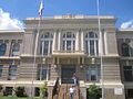
The DeSoto Parish Courthouse in Mansfield.
-
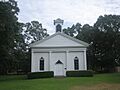
The historic Keachi Presbyterian Church.
-
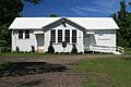
The Longstreet Rosenwald School.
-
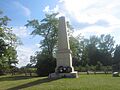
A monument at Mansfield Battle Park.
-
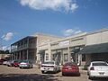
Downtown Mansfield, part of the historic district.

_Presbyterian_Church_IMG_0933.JPG)


