
National Register of Historic Places listings in East Hampton (town), New York facts for kids
The Town of East Hampton, New York is a special place with many historic buildings and sites. These places are so important that they are listed on the National Register of Historic Places. This list helps protect them and reminds us of their history.
You can even see where some of these historic spots are on an online map if their exact location coordinates are shared. Let's explore some of these amazing places!
Contents
Historic Places in East Hampton
AN/FPS-35 Radar Tower and Antenna

Imagine a giant radar station from the 1960s! The AN/FPS-35 Radar Tower and Antenna is the only one left of 12 built by the Sperry Corporation. It's located on Montauk Point State Parkway in Montauk. This huge tower was used to detect things far away, like airplanes. It was added to the National Register on June 4, 2002.
Cedar Island Lighthouse

Lighthouses are like guardians of the sea, helping ships find their way. The Cedar Island Lighthouse stands on Cedar Point Road in Northwest Harbor. It was built to guide boats safely through the waters. This beautiful lighthouse became a historic site on April 18, 2003.
East Hampton Railroad Station

Train stations are often busy places, and the East Hampton Railroad Station has seen many travelers come and go. It's located on Railroad Avenue, between Race and Newtown Lanes, in East Hampton. This station is a reminder of how people used to travel and how important trains were for connecting towns. It was added to the National Register on June 2, 2000.
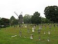
Historic Windmills


East Hampton is home to several historic windmills. These tall structures with spinning blades were once very important for grinding grain into flour. They show us how people used natural power long ago.
- Gardiners Island Windmill: This windmill is found on Gardiners Island. It was listed on December 27, 1978.
- Hayground Windmill: Located at Windmill Lane in East Hampton, this windmill also joined the list on December 27, 1978.
- Hook Windmill: You can find the Hook Windmill on North Main Street in East Hampton. It was added to the National Register on December 27, 1978.
- Wainscott Windmill: This windmill is on the Georgica Association grounds in Wainscott. It was also listed on December 27, 1978.
H.M.S. CULLODEN Shipwreck Site

Not all historic places are buildings on land! The H.M.S. CULLODEN Shipwreck Site is underwater near Culloden Point in Montauk. The H.M.S. CULLODEN was a British warship that sank in 1776 during the American Revolutionary War. This shipwreck is a fascinating underwater museum, telling a story of a time of conflict. It was added to the National Register on March 5, 1979.
Montauk Point Light

The Montauk Point Light is one of the most famous lighthouses in New York. It stands proudly at Montauk Point, at 2000 Montauk Highway in Montauk. This lighthouse has been guiding ships for centuries and is a true landmark. It was even named a National Historic Landmark on July 7, 1969, which is an even higher level of historical importance!
Montauk Manor

The Montauk Manor is a large and impressive building located on Fairmont Avenue in Montauk. It's a grand structure that reminds us of a different era of architecture and style. This historic manor was added to the National Register on August 23, 1984.
Jackson Pollock House and Studio

For art lovers, the Jackson Pollock House and Studio is a very special place. It's located at 830 Fireplace Road in Springs. This was the home and workplace of Jackson Pollock, a very famous American artist known for his unique "drip painting" style. You can almost imagine him creating his masterpieces here! This site was designated a National Historic Landmark on April 19, 1994.
Images for kids
-
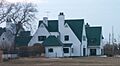
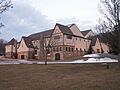
Caleb Bragg Estate
-
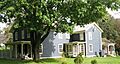
Briar Patch Road Historic District
-
Buell's Lane Historic District
-
East Hampton Village District
-
Egypt Lane Historic District
-
Jericho Historic District
-
Jones Road Historic District
-
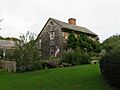
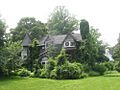
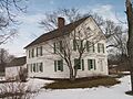
Miss Amelia's Cottage
-

Montauk Association Historic District
-
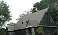
Montauk Tennis Auditorium
-
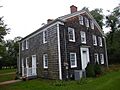
Thomas Moran House
-
North Main Street Historic District
-

Pantigo Road Historic District
-
Ambrose Parsons House
-
Pleasants House
-
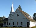
Saint Thomas' Chapel
-
Stephen Sherrill House
-
Thomas Strong House


