Culloden Point facts for kids
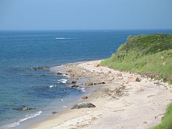
Culloden Point is a small piece of land that sticks out into the water, located north of Montauk, New York. It marks the eastern entrance to Fort Pond Bay from Gardiners Bay. This area is known for its history, including a famous shipwreck and unique homes.
Contents
The Shipwreck of HMS Culloden
A Stormy Night in 1781
During the American Revolutionary War, a large British warship named HMS Culloden got stuck here. This happened early on January 24, 1781. The ship was trying to escape a big winter gale and snowstorm. It was sailing from Block Island Sound into the open Atlantic Ocean with two other British warships.
The lead ship, HMS Bedford, turned around at midnight. Its captain realized they had not passed Montauk Point safely. But Captain George Balfour of the Culloden kept going until 4 AM. That's when lookouts saw waves breaking ahead. They tried to turn the ship back, but it was too late.
Efforts to Save the Ship
The next day, people tried to get the Culloden unstuck, but they couldn't. Captain Balfour then ordered the ship to be burned down to the waterline. This was done to stop American Patriot forces from capturing it. Before burning it, they took off valuable bronze cannons and other supplies. They left behind the old iron cannons.
Discovering the Wreck Today
The wreck of the Culloden was found in the 1970s. Parts of it washed ashore, and some pieces were even used for beach campfires! Today, one of the cannons from the ship is on display. You can see it at the East Hampton Marine Museum in Amagansett, New York. This museum has many items from the Culloden.
Other cannons are still at the bottom of the sea, close to shore. They are about 20 to 25 feet (6 to 7.6 meters) deep. The wreck is now a protected site. It is listed on the National Register of Historic Places. It is also the first underwater park on Long Island, New York.
Visiting the Underwater Park
You can reach this underwater park by a single-lane gravel road. It's at the west end of Soundview Drive. Scuba divers use a large rock with pebbles on top of it as a guide. This rock is north of the bluff stairs. Divers follow a direction of 333 degrees from the rock to reach the wreck. It's about 150 feet (46 meters) offshore. Buoys mark the area where the ship's remains are.
Usually, you can't see much of the wreck itself. Often, only rust stains in the sand are visible. But sometimes, after big storms, parts of the ship's hull can be seen. Before the wreck was found in the 1970s, this area was called Will's Point. It might have been named after Will Indian, a herder from old East Hampton Town records.
The Amistad at Culloden Point
In 1839, the ship Amistad anchored at Culloden Point. This happened after enslaved people on board took control of the ship. The surviving crew tried to trick them into thinking they had returned to Africa. The group went to the village of Montauk to get supplies. However, the ship was then captured here by the USS Washington.
Leisurama Homes
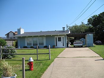
In the early 1960s, about 200 special homes were built at Culloden Point. These were Leisurama prefabricated homes. This means they were built in parts in a factory and then put together on site. They were designed by Andrew Geller. These homes were first sold from a display on the ninth floor of Macy's department store in New York City.
 | Sharif Bey |
 | Hale Woodruff |
 | Richmond Barthé |
 | Purvis Young |


