
National Register of Historic Places listings in Etowah County, Alabama facts for kids

This article is a list of amazing places in Etowah County, Alabama that are on a special list called the National Register of Historic Places. Think of it like a Hall of Fame for buildings and areas that are super important to American history and culture. When a place is on this list, it means it's recognized for its unique story or design. It also helps protect these places for future generations to enjoy and learn from.
In Etowah County, Alabama, there are 13 different buildings and areas that have made it onto this important list. Each one has a special history!
Contents
Historic Places in Gadsden
Many of Etowah County's historic places are found in the city of Gadsden, Alabama. These sites show us what life was like in the past and how the city grew.
Important Buildings in Gadsden
- Alabama City Library: This building, also known as the Howard Gardner Nichols Memorial Library, was added to the list in 1974. It's a key part of the Alabama City area of Gadsden.
- Eleventh Street School: Listed in 1984, this old school building reminds us of how education has changed over the years in Gadsden.
- Gadsden Times-News Building: This building, added in 1983, was once home to the local newspaper. Imagine all the news stories that were written here!
- Charles Gunn House: This historic home, listed in 1993, is a beautiful example of older houses in Gadsden.
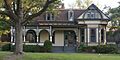
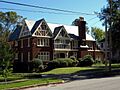
- Colonel O.R. Hood House: Another historic home, added in 1986, showing the kind of places important people lived in the past.
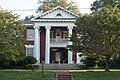
- U.S. Post Office (Gadsden): This grand building, listed in 1976, served as the main post office for Gadsden. It's where countless letters and packages passed through.
Historic Districts in Gadsden
Historic districts are areas with many important buildings that together tell a story.
- Alabama City Wall Street Historic District: This district, listed in 2002, covers a part of Gadsden that was once a busy commercial area. It includes buildings like the Ritz Theatre.
- Forrest Cemetery Chapel and Comfort Station: This area, added in 1992, includes a chapel and other structures within a historic cemetery.
- Gadsden Downtown Historic District: Listed in 1997, this large district covers the heart of downtown Gadsden. It includes many buildings along Broad Street, like the White Palace Cafe, showing what the city center looked like long ago.
- Turrentine Historic District: This residential district, added in 2005, features many historic homes along Turrentine Avenue.
Places for Entertainment and Community in Gadsden
- Mort Glosser Amphitheater: Also known as Legion Park Bowl, this outdoor theater was listed in 1988. It's a place where people have gathered for performances and events for many years.
Historic Places in Attalla
The nearby city of Attalla, Alabama also has its own special places on the National Register.
Important Buildings in Attalla
- U.S. Post Office (Attalla): This post office building, listed in 1983, is an important part of Attalla's history and community services.
Historic Districts in Attalla
- Attalla Downtown Historic District: Added to the list in 2013, this district includes several streets in downtown Attalla, like the area around Walker's Drug Store. It shows the historic center of the town.
Images for kids
-

The Howard Gardner Nichols Memorial Library in Gadsden.
-
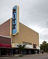
The Ritz Theatre, part of the Alabama City Wall Street Historic District.
-
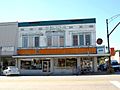
Walker's Drug Store building in the Attalla Downtown Historic District.
-

The historic Eleventh Street School in Gadsden.
-
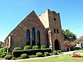
The Chapel at Forrest Cemetery in Gadsden.
-
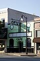
The White Palace Cafe in the Gadsden Downtown Historic District.
-
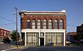
The former Gadsden Times-News Building.
-
The Charles Gunn House in Gadsden.
-
The Colonel O.R. Hood House in Gadsden.
-
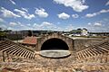
The Mort Glosser Amphitheater in Gadsden.
-
A historic home on Turrentine Avenue in Gadsden.
-
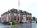
The U.S. Post Office in Attalla.
-

The U.S. Post Office in Gadsden.


