
National Register of Historic Places listings in Floyd County, Georgia facts for kids

Welcome to Floyd County, Georgia! This page is all about amazing places in Floyd County that are listed on the National Register of Historic Places (NRHP). Think of the NRHP as a special list of buildings, areas, and sites across the United States that are super important because of their history, architecture, or what they mean to a community.
When a place is on this list, it means it's recognized for its value and efforts are made to protect it for future generations. Floyd County has many such treasures, from old homes and schools to unique natural sites. Let's explore some of them!
Contents
- Historic Gems in Floyd County
- Berry College: A Beautiful Campus with History
- Etowah Mounds: Ancient History Uncovered
- Rome Clock Tower: A Landmark on the Hill
- Chieftains: A Home with a Story
- Double-Cola Bottling Company: A Sweet Piece of History
- Floyd County Courthouse: Where Decisions Were Made
- U.S. Post Office and Courthouse: A Place for Mail and Justice
- Myrtle Hill Cemetery: Resting Place of History
- Old Brick Mill: A Glimpse into Industry
- Other Historic Places in Floyd County
- Images for kids
Historic Gems in Floyd County
Berry College: A Beautiful Campus with History

One of the most famous places in Floyd County is Berry College, located just north of Rome, Georgia. It's not just a college; it's also a historic district! Founded by Martha Berry in 1902, this school started as a place for rural children to get an education. The campus is known for its stunning natural beauty and amazing buildings. It's so big and beautiful, it feels like a national park!
Etowah Mounds: Ancient History Uncovered

Imagine a place where people lived thousands of years ago! The Etowah Mounds are a very important site on the banks of the Etowah River. These large mounds were built by Native American people, known as the Mississippian culture, between 1000 and 1550 AD. They used these mounds for homes, temples, and burials. It's a fantastic place to learn about ancient civilizations and how people lived long before us. It's even a National Historic Landmark, which is an even higher level of historical importance!
Rome Clock Tower: A Landmark on the Hill

Standing tall on Neely Hill, the Rome Clock Tower is one of the most recognizable symbols of Rome, Georgia. Built in 1871, this impressive tower once held the city's main water supply. Today, it's a beloved landmark, reminding everyone of Rome's past. You can even climb to the top for amazing views of the city!
Chieftains: A Home with a Story

The Chieftains house, also known as the Major Ridge Home, is another National Historic Landmark in Rome. This house belonged to Major Ridge, an important leader of the Cherokee Nation in the early 1800s. It's a significant place for understanding the history of Native Americans in Georgia and the challenges they faced.
Double-Cola Bottling Company: A Sweet Piece of History

Did you know that a soda company building could be historic? The Double-Cola Bottling Company building in Rome is on the NRHP. It's a cool example of how everyday businesses from the past are important parts of our history. This building shows the style of factories and businesses from the early 20th century.
Floyd County Courthouse: Where Decisions Were Made

The Floyd County Courthouse in Rome is where many important decisions for the county have been made over the years. Courthouses are often grand buildings that show the importance of law and government in a community. This building has seen a lot of history unfold within its walls.
U.S. Post Office and Courthouse: A Place for Mail and Justice

Another important building in Rome is the U.S. Post Office and Courthouse. This building served two main purposes: handling mail for the community and housing courts where legal cases were heard. It's a great example of how government buildings were designed to be both functional and impressive.
Myrtle Hill Cemetery: Resting Place of History

While it might seem unusual, Myrtle Hill Cemetery in Rome is also a historic district. Cemeteries can be important historical sites because they tell us about the people who lived in an area, their lives, and even the art and architecture of different times. Many notable people from Floyd County's past are buried here.
Old Brick Mill: A Glimpse into Industry

In Lindale, Georgia, you can find the Old Brick Mill. Mills like this were once very important for grinding grains into flour, which was a basic need for communities. This old brick mill shows us how people worked and produced goods in the past, before modern factories.
Other Historic Places in Floyd County
Floyd County is full of other interesting historic places, including many homes and entire neighborhoods that are recognized for their unique history and architecture. These include:
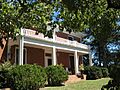
- The Dr. Robert Battey House in Rome.
- The Between the Rivers Historic District in Rome, named for its location between the Etowah and Oostanaula Rivers.
- The Cave Spring Commercial Historic District and the Cave Spring Residential Historic District in Cave Spring, Georgia, which preserve the look and feel of this charming town's past.
- The Georgia School for the Deaf Historic District in Cave Spring, highlighting the history of education for deaf students.
- The Sardis Presbyterian Church and Cemetery in Coosa, Georgia, a place of worship with a long history.
These are just some of the many places in Floyd County that help us understand and appreciate the rich history of Georgia!
Images for kids
-
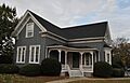
The Dr. Robert Battey House.
-
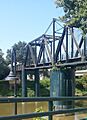
A bridge in the Between the Rivers Historic District.
-
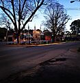
Downtown Cave Spring Commercial Historic District.
-
The old Cave Spring Railroad Station.
-
The Simmons House in Cave Spring.
-

The Sullivan-Hillyer House.
-
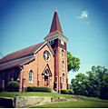
Thankful Baptist Church.


