
National Register of Historic Places listings in Floyd County, Kentucky facts for kids

Welcome to Floyd County, Kentucky! This page is all about the cool and historic places in Floyd County that are listed on the National Register of Historic Places. Think of this register as a special list of buildings, sites, and areas across the United States that are important to our country's history. When a place is on this list, it means it's worth protecting and remembering for future generations.
In Floyd County, there are 15 amazing places on this list. One of them is even more special, called a National Historic Landmark, which means it's super important to the history of the entire nation! Let's explore some of these fascinating spots.
Contents
Historic Places in Floyd County
Floyd County is home to many buildings and sites that tell stories from the past. These places help us understand how people lived, worked, and even fought long ago.
Prestonsburg's Historic Buildings
Many of the historic places in Floyd County are found in the city of Prestonsburg. These buildings often show us what homes and businesses looked like many years ago.
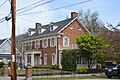
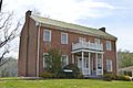
- G.D. Callihan House: Located at 105 W. Graham Street, this house was added to the National Register on May 18, 1989. It's a great example of old homes in the area.
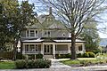
- B.F. Combs House: You can find this historic house at 41 N. Arnold Avenue. It was also listed on May 18, 1989, showing the style of homes from that time.
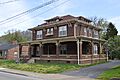
- Fitzpatrick-Harmon House: This house at 102 E. Court Street joined the list on May 18, 1989. It's another piece of Prestonsburg's past.
- Harkins Law Office Building: At 1 S. Arnold Avenue, this building was once a law office. It became a historic site on May 18, 1989.
- Joseph D. Harkins House: This large house at 204 N. Arnold Avenue was home to Joseph D. Harkins. It was added to the register on May 18, 1989.
- Samuel May House: Located at 690 N. Lake Drive, this house is a very old and important building. It was listed on April 1, 1980.
- May-Fitzpatrick House: Another historic home, this one is at 39 S. Arnold Avenue. It was recognized on May 18, 1989.
- May-Latta House: Found at 33 N. Arnold Avenue, this house also became a historic site on May 18, 1989.
- Methodist Episcopal Church, South: This church on S. Arnold Avenue is a significant religious building from the past. It was listed on May 18, 1989.
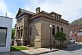
- US Post Office-Prestonsburg: The old post office building at Central Avenue and E. Court Street is now a historic landmark. It was added to the list on May 18, 1989.
Historic Districts and Battlefields
Not all historic listings are single buildings. Some are entire areas or important historical sites where big events happened.
- Front Street Historic District: This area along Front Street in Prestonsburg is a whole district of historic buildings. It gives us a look at what the town's main street was like long ago. It was listed on May 18, 1989.
- Middle Creek Battlefield: This is a very important site, located about 3 miles west of Prestonsburg. It's where a major battle took place during the American Civil War. Because of its national importance, it's a National Historic Landmark, listed on March 26, 1992.
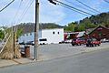
- Wheelwright Commercial District: In the city of Wheelwright, the Main Street area is a historic commercial district. It shows how businesses operated in the past. It was listed on November 19, 1980.
Historic Bridges
Bridges are also important parts of history, connecting communities and helping people travel.
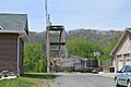
- Town Branch Bridge: This bridge carries County Road 1334 over the Levisa Fork. It was recognized as historic on May 18, 1989.
- West Prestonsburg Bridge: This bridge crosses the Levisa Fork, connecting Prestonsburg with West Prestonsburg. It was listed on May 18, 1989.
Images for kids
-

The G.D. Callihan House in Prestonsburg.
-
The B.F. Combs House.
-
The Fitzpatrick-Harmon House.
-
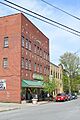
A view of the Front Street Historic District.
-
The Harkins Law Office Building.
-

The Joseph D. Harkins House.
-
The Samuel May House.
-
The May-Fitzpatrick House.
-
The May-Latta House.
-
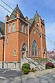
The historic Methodist Episcopal Church, South.
-

The Middle Creek Battlefield, a National Historic Landmark.
-

The Town Branch Bridge over Levisa Fork.
-
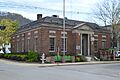
The former U.S. Post Office in Prestonsburg.
-
The West Prestonsburg Bridge.
-
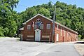
A building in the Wheelwright Commercial District.


