
National Register of Historic Places listings in Gasconade County, Missouri facts for kids

Have you ever wondered about really old and important places in your town or state? In Gasconade County, Missouri, there are special spots that are officially recognized for their history! These places are listed on the National Register of Historic Places.
The National Register of Historic Places is like a special list kept by the United States government. It helps protect buildings, sites, and districts that are important because of their history, architecture, or what happened there. When a place is on this list, it means it's a valuable part of our country's story.
In Gasconade County, Missouri, there are 9 different places and areas that have made it onto this important list. Let's explore some of them!
Historic Places in Gasconade County
Here are some of the cool historic places you can find in Gasconade County:
- Hermann Historic District
- Location: Hermann
- Listed: February 1, 1972
- What it is: This is a large area in the city of Hermann. It includes many historic buildings and streets that show what the town was like long ago. It's so important that its boundaries have been expanded twice to include more historic spots!
- Kotthoff-Weeks Farm Complex
- Location: Near Hermann
- Listed: March 28, 1983
- What it is: This is an old farm complex. It shows how farms used to operate in the past.
- Old Stone Hill Historic District
- Location: Hermann
- Listed: May 21, 1969
- What it is: This historic district is famous for the Stone Hill Winery. It's an important area that tells the story of winemaking in Missouri.
- Peenie Petroglyph Archeological Site
- Location: Near Bem
- Listed: July 29, 1969
- What it is: This is an ancient site with petroglyphs. Petroglyphs are drawings or carvings made on rocks by people from long, long ago. This site helps us learn about early human history in the area.
- William Poeschel House
- Location: West of Hermann
- Listed: June 21, 1990
- What it is: This is a historic house that belonged to William Poeschel. It's recognized for its historical importance.
- The Rotunda
- Location: City Park, Hermann
- Listed: November 2, 1995
- What it is: The Rotunda is a unique building located in Hermann's City Park. It's a special landmark in the community.
- Ruskaup House
- Location: West of Drake
- Listed: March 29, 1983
- What it is: Another historic house, the Ruskaup House, is located near Drake.
- Shobe-Morrison House
- Location: West of Morrison
- Listed: February 10, 1983
- What it is: This historic house is found near the town of Morrison.
- Vallet-Danuser House
- Location: East of Hermann
- Listed: September 23, 1982
- What it is: This is a historic house located just outside of Hermann.
Images for kids
-
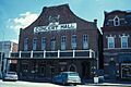
A view of the Hermann Historic District.
-
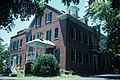
The historic Stone Hill Winery, part of the Old Stone Hill Historic District.


