
National Register of Historic Places listings in Glacier County, Montana facts for kids

Glacier County, Montana, is home to many amazing places that are part of the National Register of Historic Places. This special list includes buildings, sites, and objects that are important to the history of the United States. Think of it like a Hall of Fame for historic spots!
In Glacier County, there are 38 places on this list. Three of these are even more special: they are called National Historic Landmarks. These landmarks are considered super important to the entire country's history. Let's explore some of these cool historic sites!
Contents
Exploring Glacier County's Historic Places
Glacier County is famous for its stunning natural beauty, especially Glacier National Park. Many of the historic places here are connected to the park's early days, its development, and the people who lived and worked there.
Important Landmarks in Glacier County
Some places are so special they are called National Historic Landmarks. Glacier County has three of these!
Camp Disappointment: A Lewis and Clark Site

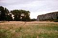
Camp Disappointment is a very important historic site located about 12 miles northeast of Browning. It was named by the famous explorers Meriwether Lewis and William Clark during their epic journey across America. In 1806, Lewis hoped to find the northernmost source of the Missouri River here. He was disappointed when he realized it wasn't the main branch, so he named the spot "Camp Disappointment." This site helps us remember the challenges and discoveries of the Lewis and Clark Expedition. It was added to the National Register on October 15, 1966.
Going-to-the-Sun Road: A Mountain Masterpiece

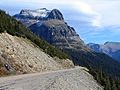
The Going-to-the-Sun Road is one of the most famous roads in the world. It winds through Glacier National Park, offering breathtaking views of mountains, valleys, and glaciers. This road is an amazing example of engineering. It was built between 1921 and 1932 and was a huge challenge because of the tough mountain terrain. The road is important not just for its beauty but also for how it was built, showing how people could create something incredible in a difficult environment. It became a National Historic Landmark on June 16, 1983.
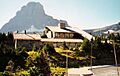
Great Northern Railway Buildings: Park History

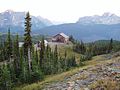
The Great Northern Railway Buildings are a collection of historic structures within Glacier National Park. These buildings, like the famous Granite Park Chalet, were built by the Great Northern Railway company. The railway played a huge role in bringing tourists to Glacier National Park in the early 1900s. These buildings helped visitors explore the park and enjoy its beauty. They show how important railways were in developing tourism in national parks. This collection of buildings was recognized as a National Historic Landmark District on May 28, 1987.
Other Notable Historic Places
Beyond the National Historic Landmarks, many other sites in Glacier County tell important stories.
Chief Mountain Border Station and Quarters

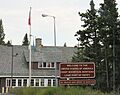
The Chief Mountain Border Station and Quarters is a unique building right at the border between the United States and Canada. It's located on Montana Highway 17 within Glacier National Park. This station was built to welcome visitors and manage traffic crossing the border. Its design fits in with the park's natural surroundings. It was listed on May 20, 2008.
Glacier County Courthouse

The Glacier County Courthouse is located at 512 East Main Street in Cut Bank. This building is where many important decisions for the county are made. Courthouses often have interesting architecture and represent the history of local government and community life. It was added to the National Register on June 25, 2013.
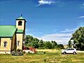
Holy Family Mission

The Holy Family Mission is an important historical site located east of Browning. Missions like this one played a significant role in the history of the region, especially in their interactions with local Native American communities. They often served as centers for education and community gathering. This mission was listed on June 14, 1982.
Logan Pass Visitor Center

The Logan Pass Visitor Center is a popular stop for visitors along the Going-to-the-Sun Road in Glacier National Park. It's a place where people can learn about the park's wildlife, plants, and geology. Visitor centers are key to helping people understand and appreciate national parks. This center was added to the National Register on April 15, 2008.
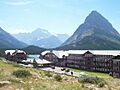
Many Glacier Hotel Historic District

The Many Glacier Hotel Historic District is located west of Babb. The Many Glacier Hotel itself is a grand, historic hotel within Glacier National Park. It was built by the Great Northern Railway and is known for its Swiss-style architecture and stunning views of Swiftcurrent Lake. It has welcomed guests for over a century, offering a unique experience in the heart of the park. This district was listed on January 19, 1996.
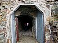
Ptarmigan Tunnel

The Ptarmigan Tunnel is an amazing tunnel located north of Ptarmigan Lake in Glacier National Park. This tunnel was blasted through solid rock to create a passage for hikers, making it easier to explore certain parts of the park. It's a testament to the hard work involved in making the park accessible. It was listed on February 14, 1986.
Rising Wolf (boat)

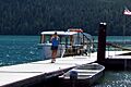
The boat Rising Wolf is a historic vessel that used to sail on St. Mary Lake in Glacier National Park. Built in 1926, this boat helped tourists explore the lake and enjoy the park's scenery from the water. It's now known as Little Chief. Historic boats like this remind us of how people traveled and experienced nature in the past. It was added to the National Register on November 14, 2016.
Images for kids
-
Camp Disappointment, a historic campsite.
-
The Chief Mountain Border Station.
-

The Glacier County Courthouse in Cut Bank.
-
The incredible Going-to-the-Sun Road.
-
Granite Park Chalet, part of the Great Northern Railway Buildings.
-
The historic Holy Family Mission.
-
The Logan Pass Visitor Center.
-
The beautiful Many Glacier Hotel.
-
The Ptarmigan Tunnel.
-
The historic boat Rising Wolf.
