
National Register of Historic Places listings in Grayson County, Kentucky facts for kids

Hey there! Did you know that some places are so special and important that they get listed on something called the National Register of Historic Places? It's like a special club for buildings, areas, and even ancient sites that tell us about the past. When a place is on this list, it means it's worth protecting and remembering because of its history, architecture, or what it teaches us about people who lived long ago.
This page is all about the cool historic places in Grayson County, Kentucky. There are 11 different spots here that are super important! Let's take a look at some of them.
Contents
Historic Buildings and Homes
Many of the places on the National Register are old buildings or homes that have amazing stories.
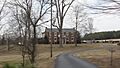
The Cedars
The Cedars is a beautiful old house located east of Leitchfield. It was built a long time ago and was added to the National Register in 1976. Imagine living in a house that's been around for so many years!
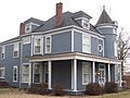
Hunter House
Also in Leitchfield, you'll find the Hunter House at 118 West Walnut Street. This house joined the list in 1985. It's another example of the cool old homes that show us what life was like in Grayson County in the past.
Jack Thomas House
The Jack Thomas House is right in the heart of Leitchfield, at 108 East Main Street. It became a historic place in 1976, the same year as The Cedars. These old homes help us see how towns like Leitchfield have grown and changed over time.
Walnut Grove School
Near Caneyville, there's an old school called Walnut Grove School on Walnut Grove Road. This school was added to the list in 1988. Think about all the kids who learned and played there many years ago! It's a reminder of how education has always been important.
Historic Districts and Areas
Sometimes, it's not just one building, but a whole area that's important. These are called historic districts.
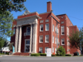
Court Square Historic District
In the center of Leitchfield, you'll find the Court Square Historic District. This area includes the county courthouse and the streets around it, like Walnut and Market Streets. It was recognized in 1984. This district is special because it shows how the town center looked and functioned in earlier times.
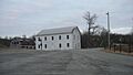
Falls of Rough Historic District
The Falls of Rough Historic District is located in Falls of Rough. This district was added to the National Register in 1978. What's cool about this one is that it actually stretches into another county, Breckinridge County! It's a great example of how history can connect different places.
Ancient Sites and Petroglyphs
Some of the most fascinating historic places aren't buildings at all, but ancient sites left by people who lived thousands of years ago!
Crow Hollow Petroglyphs
Near Clarkson, there's a site called the Crow Hollow Petroglyphs. Petroglyphs are ancient drawings or carvings made on rocks. This site was added to the list in 1989. Because these sites are so old and fragile, their exact location is kept secret to protect them. It's amazing to think about the messages people left on these rocks so long ago!
Saltsman Branch Petroglyphs
Another petroglyph site is the Saltsman Branch Petroglyphs, located near Moutardier. Like Crow Hollow, this site has ancient rock carvings and was listed in 1989. It's another important clue about the early people who lived in this area.
Saltsman Branch Shelter Petroglyphs
Very close to the Saltsman Branch Petroglyphs, there's another site called the Saltsman Branch Shelter Petroglyphs. This one is special because the carvings are found in a rock shelter. It was also added to the National Register in 1989. These sites give us a peek into the art and lives of ancient cultures.
Other Unique Historic Places
Grayson Springs (resort)
South of Clarkson, there's a place called Grayson Springs. This was once a popular resort, a place where people would go to relax and enjoy the natural springs. It was added to the National Register in 1978. Imagine people from long ago coming here for vacations!
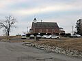
St. Augustine Catholic Church
In Grayson Springs, you can find the St. Augustine Catholic Church. This beautiful church was recognized as a historic place in 1989. Churches often play a big role in a community's history, and this one is no exception.
Images for kids
-
The Cedars, a historic home in Leitchfield.
-
The Grayson County Courthouse, part of the Court Square Historic District.
-
A view of the Falls of Rough Historic District.
-

An overview of the former Grayson Springs resort site.
-
The Hunter House in Leitchfield.
-
St. Augustine Catholic Church in Grayson Springs.
-

The Jack Thomas House in Leitchfield.


