
National Register of Historic Places listings in Haywood County, Tennessee facts for kids

Have you ever wondered about old buildings or special places that tell a story about the past? In Haywood County, Tennessee, there are many such spots! These places are so important that they are listed on the National Register of Historic Places. This is like a special list kept by the United States government. It helps protect buildings, sites, and objects that are important to American history, architecture, archaeology, engineering, or culture.
When a place is on this list, it means it's recognized as a valuable part of our heritage. It helps people learn about how things used to be and why certain places are special. In Haywood County, there are 14 different properties and areas that have earned a spot on this important list. Let's explore a few of them!
Contents
Discovering Haywood County's Historic Gems
Haywood County is full of history, and many of its old buildings and areas are protected. These places help us understand the lives of people who lived here long ago.
Homes with History: The Joshua K. Hutchison House
One of the special homes on the list is the Joshua K. Hutchison House. It's located in Brownsville, Tennessee. This house was built a long time ago and shows us what homes looked like in the past. It's a great example of the architecture from its time, and it tells us about the families who lived there.
Sacred Spaces: Churches and Temples
Many historic churches and temples in Haywood County are also on the National Register. These buildings are important not just for their religious history, but also for their beautiful designs and the stories they hold.
Temple Adas Israel: A Unique Synagogue
The Temple Adas Israel in Brownsville is a very special place. It's an old synagogue, which is a place of worship for Jewish people. This temple is one of the oldest synagogues in Tennessee! It was built in 1882 and has a unique design that makes it stand out. It reminds us of the diverse communities that have lived in Haywood County.
Woodlawn Baptist Church and Cemetery: A Community Hub
Another important religious site is the Woodlawn Baptist Church and Cemetery near Nutbush, Tennessee. Churches like this were often the center of community life in the past. They were places for worship, gatherings, and even schools. The cemetery nearby also tells stories of the people who lived and worked in the area.
Zion Church: A Historic Landmark
Also in Brownsville, the Zion Church is another significant building. Like many historic churches, it represents the faith and community spirit of the people who built and worshipped there. Its architecture and history make it a valuable part of the county's heritage.
Historic Districts: Whole Neighborhoods with Stories
Sometimes, it's not just one building that's historic, but a whole group of buildings or a neighborhood. These are called historic districts. They show us how towns grew and changed over time.
College Hill Historic District: A Glimpse into the Past
The College Hill Historic District in Brownsville is one such area. It includes many old buildings along important roads like U.S. Routes 70 and 79. Walking through this district is like taking a step back in time, seeing the different styles of homes and businesses that were built there.
Dunbar-Carver Historic District: Community and Culture
The Dunbar-Carver Historic District in Brownsville is another important neighborhood. It's named after two famous figures, Paul Laurence Dunbar (a poet) and George Washington Carver (a scientist). This district tells the story of a specific community and its cultural heritage in Brownsville.
Jefferson Street Historic District: Downtown History
The Jefferson Street Historic District covers a part of downtown Brownsville. This area was likely a busy center for shops and homes. Protecting these districts helps keep the unique look and feel of the town's past alive.
North Washington Historic District: Preserving Neighborhoods
The North Washington Historic District also in Brownsville, helps preserve another part of the town's historic neighborhoods. These districts are important because they show how communities were planned and how people lived in different parts of the town.
Why Are These Places Important?
Listing these places on the National Register of Historic Places helps us:
- Learn about history: Each place has a story about the people, events, or ways of life from the past.
- Protect old buildings: It encourages people to take care of these special places so they don't get torn down or changed too much.
- Understand our culture: These sites show us how our communities and country have grown and developed over many years.
- Boost local pride: Having historic places makes a community unique and gives people a sense of pride in their heritage.
Haywood County's historic places are like open-air museums, each one a piece of a larger puzzle that tells the story of Tennessee and the United States.
Images for kids
-
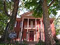
The Joshua K. Hutchison House, a historic home in Brownsville.
-
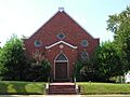
Temple Adas Israel, one of Tennessee's oldest synagogues.
-
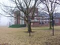
Woodlawn Baptist Church and Cemetery, a historic community hub.
-
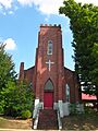
Zion Church, another important historic church in Brownsville.


