
National Register of Historic Places listings in Iredell County, North Carolina facts for kids

Did you know that many old buildings and places in the United States are super important? They are so special that they get added to a list called the National Register of Historic Places. This list helps protect them so people can learn about history for many years to come.
Iredell County, North Carolina has lots of these amazing historic spots! This page will tell you about some of the cool places in Iredell County that are on this special list. You can find old churches, historic homes, and even entire neighborhoods that tell stories about the past.
Contents
Historic Districts: Explore Old Neighborhoods!
Historic districts are like time capsules! They are areas with many old buildings that together show how a town or city used to look. Walking through them is like stepping back in time.
Statesville's Historic Areas
- Academy Hill Historic District: This area in Statesville was added to the list in 1980. It includes streets like Western Avenue, Bell, Mulberry, Wise, and Armfield. Imagine what life was like here long ago!
- East Broad Street-Davie Avenue Historic District: Also in Statesville, this district became historic in 1980. It covers Davie Avenue, Broad, and Elm Streets.
- McElwee Houses: A small group of historic houses at 122, 126, 134, and 140 Water Street in Statesville. They were recognized in 1980.
- Mitchell College Historic District: This district includes parts of NC 90 and U.S. 70 in Statesville. It was first listed in 1980, and then made bigger in 2002. It's centered around the historic Mitchell College.
- South Race Street Historic District: This area in Statesville, listed in 1995, is roughly bounded by S. Race Street, Western Avenue, W. Armfield Street, W. Bell Street, W. Sharpe Street, and S. Oak Street.
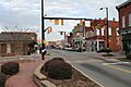
- Statesville Commercial Historic District: This part of Statesville, listed in 1980, is the old business area. It's roughly bounded by Front, Meeting, Broad, and Tradd Streets. Think about all the shops and businesses that were here!
Mooresville's Historic Areas
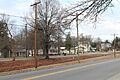
- Mooresville Historic District: In Mooresville, this district includes parts of NC 115 and NC 152. It was added to the list in 1980.
- Mooresville Mill Village Historic District: This district in Mooresville was added in 2012. It's bounded by Wilson, Cauldwell, Kennette, Lutz, Messeck, & Catawba Avenues, Smith & Bruce Streets, and Shearers Road. Mill villages were special neighborhoods built for factory workers.
- South Broad Street Row: A row of historic buildings at 251-311 S. Broad Street in Mooresville. It was listed in 1980.
Historic Churches and Cemeteries
Many old churches in Iredell County are on the list. They are important not just for their buildings, but also for the history of the communities they served.
- Bethesda Presbyterian Church, Session House and Cemetery: Located in Houstonville, this church and its grounds were listed in 1980.
- Center Street A.M.E. Zion Church: This church on S. Center Street in Statesville was recognized in 1980.
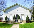
- Centre Presbyterian Church, Session House and Cemeteries: In Mount Mourne, this historic church and its cemeteries were listed in 1980.
- Coddle Creek Associate Reformed Presbyterian Church, Session House and Cemetery: Another historic church in Mount Mourne, listed in 1980.
- Damascus Baptist Church Arbor: This unique structure, an open-air meeting place, is located off SR 1158 and SR 1582 in Harmony. It was listed in 1980.
- Ebenezer Academy, Bethany Presbyterian Church and Cemetery: Found on U.S. 21 in Houstonville, this site includes an old academy, church, and cemetery. It was added to the list in 1980.
- Snow Creek Methodist Church and Burying Ground: This church and its cemetery are located off SR 1904 in Harmony. They became historic in 1980.
Important Historic Homes
Iredell County has many beautiful and historic homes that tell stories of the families who lived there long ago.
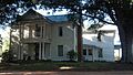
- Espy Watts Brawley House: This house at 601 William Street in Mooresville was listed in 1980.
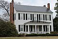
- Perciphull Campbell House: Located on SR 1832 in Union Grove, this house was added to the list in 1980.
- Cornelius House: This home at SR 1378 and SR 1302 in Mooresville was listed in 1980.
- Daltonia: Found on SR 2115 in Houstonville, this property was recognized in 1980.
- Davidson House: In Troutman, this house on SR 1337 was listed in 1980.
- Henry Eccles House: This house on SR 2145 and SR 2180 in Statesville was added in 1980.
- Falls-Hobbs House: Located on SR 1303 in Statesville, this house was listed in 1982.
- Feimster House: This home on SR 1516 in Statesville was recognized in 1982.
- Gaither House: Found on NC 901 in Harmony, this house was listed in 1980.
- Hargrave House: This house on NC 152 and NC 150 in Statesville was added in 1982.
- Holland-Summers House: Located off SR 1904 in Harmony, this house was listed in 1980.
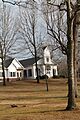
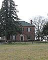
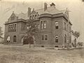
- George Houston House: This home on NC 115 in Mount Mourne was recognized in 1980.
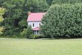
- Johnson-Neel House: About 4 miles west of Mooresville off NC 150, this house was listed in 1975.
- King-Flowers-Keaton House: This house on NC 115 and SR 1905 in Statesville was added in 1980.
- McClelland-Davis House: Located on SR 1551 in Statesville, this house was listed in 1980.
- Morrison-Campbell House: Found off SR 2125 in Harmony, this house was recognized in 1980.
- Morrison-Mott House: This home at 332 N. Center Street in Statesville was added in 1980.
- Col. Silas Alexander Sharpe House: Located at 402 S. Center Street in Statesville, this house was listed in 1980.
- Henry Turner House and Caldwell-Turner Mill Site: This property on SR 2145 in Statesville was recognized in 1980.
- Welch-Nicholson House and Mill Site: Near Houstonville, this site was added in 1980.
Other Notable Historic Places
Iredell County also has other unique historic sites, from old forts to important public buildings.
- Allison Woods: This large area east and south of US 21 near the South Yadkin River in Statesville was listed in 1995. It's a natural and historic landscape.
- Farmville Plantation: Southeast of Elmwood off US 70 on SR 2362, this plantation was listed in 1973.
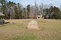
- Fort Dobbs: This historic fort on Fort Dobbs Road in Statesville is a very important site. It was listed way back in 1970! It was a frontier fort during the French and Indian War.
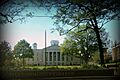
- Iredell County Courthouse: The courthouse on S. Center Street in Statesville, between W. Prospect Street and Court Place, was listed in 1979. It's where important county decisions are made.
- Key Memorial Chapel: This chapel at 150 E. Sharpe Street in Statesville was recognized in 1980.
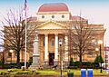
- Main Building, Mitchell College: The main building of Mitchell College on Broad Street in Statesville was listed in 1973.
- Mount Mourne Plantation: Located off NC 115 in Mount Mourne, this plantation was added to the list in 1974.
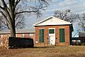
- U.S. Post Office and County Courthouse: This building at 227 S. Center Street in Statesville served as both a post office and courthouse. It was listed in 1974.
- Waddle-Click Farm: This farm on SR 2309 in Statesville was recognized in 1982.
- Wood Lawn: Located on SR 1138 in Mount Mourne, this historic property was listed in 1980.
Images for kids
-
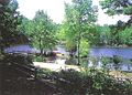
Allison Woods, a historic natural area.
-
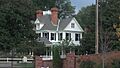
The Espy Watts Brawley House in Mooresville.
-
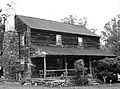
The Perciphull Campbell House.
-
Centre Presbyterian Church in Mount Mourne.
-
Coddle Creek Associate Reformed Presbyterian Church.
-
Bethany Presbyterian Church, part of the Ebenezer Academy site.
-
A monument at Fort Dobbs, a historic frontier fort.
-
The Hargrave House.
-
The George Houston House.
-
The Iredell County Courthouse.
-
The Johnson-Neel House.
-
The Main Building of Mitchell College.
-
Main Street in the Mooresville Historic District.
-
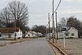
Homes in the Mooresville Mill Village Historic District.
-
Mount Mourne Plantation.
-
Buildings on South Broad Street Row in Mooresville.
-
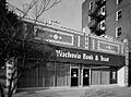
A building in the Statesville Commercial Historic District.
-
The old U.S. Post Office and County Courthouse in Statesville.
-

Wood Lawn in Mount Mourne.


.jpg)


.jpg)


