
Statesville, North Carolina facts for kids
Quick facts for kids
Statesville, North Carolina
|
|||
|---|---|---|---|

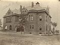
Statesville City Hall, built c. 1890–92
|
|||
|
|||
| Nickname(s):
States-vegas
|
|||

Location of Statesville, North Carolina
|
|||
| Country | United States | ||
| State | North Carolina | ||
| County | Iredell | ||
| Area | |||
| • Total | 25.44 sq mi (65.88 km2) | ||
| • Land | 25.32 sq mi (65.59 km2) | ||
| • Water | 0.11 sq mi (0.29 km2) | ||
| Elevation | 850 ft (260 m) | ||
| Population
(2020)
|
|||
| • Total | 28,419 | ||
| • Density | 1,122.17/sq mi (433.28/km2) | ||
| Time zone | UTC−5 (Eastern (EST)) | ||
| • Summer (DST) | UTC−4 (EDT) | ||
| ZIP Codes |
28625, 28677, 28687
|
||
| Area code(s) | 704, 980 | ||
| FIPS code | 37-64740 | ||
| GNIS feature ID | 2405526 | ||

Statesville is a city in North Carolina, United States. It is the main city of Iredell County. Statesville is also part of the larger Charlotte metropolitan area. The city was officially started in 1789 by the North Carolina Legislature. In 2020, about 28,419 people lived in Statesville.
Contents
- Statesville's Early History
- Statesville's Location and Climate
- Statesville's Population and People
- Statesville's Culture and History
- Statesville's Sports Teams
- Statesville's Education
- Statesville's Media and News
- Statesville's Roads and Transport
- Famous People from Statesville
- Images for kids
- See also
Statesville's Early History
Statesville's story began in 1753. People from Scotland and Ireland, along with German families, moved here from Pennsylvania. They were looking for good land to farm, with plenty of animals and water. This early settlement was called Fourth Creek Congregation. It was named after a stream north of where the city center is today. This stream was the fourth creek west of the nearby town of Salisbury. The first church was a log cabin, which is now the site of the First Presbyterian Church.
In 1755, Governor Arthur Dobbs approved building a fort about 3 miles (5 km) north of the Fourth Creek settlement. This fort was called Fort Dobbs. Soldiers from North Carolina used it to protect the western border during the French and Indian War and Anglo-Cherokee War. Fort Dobbs was a place for soldiers to live, a strong defense, a safe spot for settlers, and a place to trade with Native Americans.
In 1788, the area was divided from Rowan County. The new county was named "Iredell" after James Iredell. He was an important judge during George Washington's time as president.
One year later, in 1789, the Fourth Creek Congregation was chosen as the county seat. This is how the settlement became known as "Statesville". In 1800, the town had 95 people living there.
By 1833, leaders in Statesville started building railroads. These railroads helped connect the Piedmont area of North Carolina to other parts of the country.
Statesville grew quickly by 1858. It became a leader in making tobacco products and whiskey. It was also a big center for distributing roots and herbs.
On August 27, 1891, a passenger train had an accident on the Bostian Bridge. This bridge was 300 feet (91 meters) long. Seven train cars fell, and about 30 people died.
Statesville's Location and Climate
Statesville is in the middle of Iredell County. It is in the western part of North Carolina's Piedmont region.
The city covers about 25.44 square miles (65.88 square kilometers). Most of this area is land, with a small amount of water. Fourth Creek drains the north side of Statesville, and Third Creek drains the south side. Both creeks flow east and join before reaching the South Yadkin River.
Statesville's Weather
Statesville has a humid subtropical climate (Cfa). This means it has hot, humid summers and cool winters. Because it is at a higher elevation, Statesville is a bit cooler than many other places in the Piedmont region. Summers can have strong thunderstorms with very fast winds. Winters usually have chilly nights and sometimes snow.
| Climate data for Statesville | |||||||||||||
|---|---|---|---|---|---|---|---|---|---|---|---|---|---|
| Month | Jan | Feb | Mar | Apr | May | Jun | Jul | Aug | Sep | Oct | Nov | Dec | Year |
| Record high °F (°C) | 81 (27) |
83 (28) |
93 (34) |
95 (35) |
99 (37) |
105 (41) |
105 (41) |
106 (41) |
104 (40) |
96 (36) |
85 (29) |
80 (27) |
106 (41) |
| Mean daily maximum °F (°C) | 48.8 (9.3) |
52.9 (11.6) |
60.5 (15.8) |
70.1 (21.2) |
77.4 (25.2) |
84.1 (28.9) |
87.3 (30.7) |
85.5 (29.7) |
79.7 (26.5) |
70.8 (21.6) |
60 (16) |
51.6 (10.9) |
69.1 (20.6) |
| Daily mean °F (°C) | 37.6 (3.1) |
40.6 (4.8) |
47.6 (8.7) |
56.9 (13.8) |
65.5 (18.6) |
73.3 (22.9) |
77.0 (25.0) |
75.4 (24.1) |
69.2 (20.7) |
56.3 (13.5) |
47.1 (8.4) |
37.9 (3.3) |
57.0 (13.9) |
| Mean daily minimum °F (°C) | 26.4 (−3.1) |
28.4 (−2.0) |
34.7 (1.5) |
43.7 (6.5) |
53.6 (12.0) |
62.5 (16.9) |
66.8 (19.3) |
65.2 (18.4) |
58.8 (14.9) |
45.8 (7.7) |
34.3 (1.3) |
28.9 (−1.7) |
45.8 (7.6) |
| Record low °F (°C) | −8 (−22) |
−7 (−22) |
5 (−15) |
17 (−8) |
28 (−2) |
36 (2) |
44 (7) |
44 (7) |
30 (−1) |
16 (−9) |
6 (−14) |
−3 (−19) |
−8 (−22) |
| Average precipitation inches (mm) | 3.71 (94) |
3.18 (81) |
3.99 (101) |
4.05 (103) |
3.70 (94) |
4.27 (108) |
4.42 (112) |
4.91 (125) |
3.87 (98) |
3.23 (82) |
3.38 (86) |
3.94 (100) |
46.65 (1,184) |
| Average snowfall inches (cm) | 2.4 (6.1) |
0.8 (2.0) |
0.4 (1.0) |
0 (0) |
0 (0) |
0 (0) |
0 (0) |
0 (0) |
0 (0) |
0 (0) |
0 (0) |
1.3 (3.3) |
4.9 (12.4) |
| Source: NOAA | |||||||||||||
Statesville's Population and People
| Historical population | |||
|---|---|---|---|
| Census | Pop. | %± | |
| 1800 | 95 | — | |
| 1850 | 215 | — | |
| 1860 | 320 | 48.8% | |
| 1870 | 683 | 113.4% | |
| 1880 | 1,062 | 55.5% | |
| 1890 | 2,318 | 118.3% | |
| 1900 | 3,141 | 35.5% | |
| 1910 | 4,599 | 46.4% | |
| 1920 | 7,895 | 71.7% | |
| 1930 | 10,490 | 32.9% | |
| 1940 | 11,440 | 9.1% | |
| 1950 | 16,901 | 47.7% | |
| 1960 | 19,844 | 17.4% | |
| 1970 | 20,007 | 0.8% | |
| 1980 | 18,622 | −6.9% | |
| 1990 | 17,567 | −5.7% | |
| 2000 | 23,320 | 32.7% | |
| 2010 | 24,532 | 5.2% | |
| 2020 | 28,419 | 15.8% | |
| U.S. Decennial Census | |||
Statesville's Population in 2020
In 2020, Statesville had 28,419 people living in the city. There were 10,628 households and 6,536 families.
| Race | Number | Percentage |
|---|---|---|
| White (non-Hispanic) | 14,154 | 49.8% |
| Black or African American (non-Hispanic) | 9,054 | 31.86% |
| Native American | 56 | 0.2% |
| Asian | 545 | 1.92% |
| Other/Mixed | 1,301 | 4.58% |
| Hispanic or Latino | 3,309 | 11.64% |
Statesville's Population in 2010
In 2010, Statesville had 24,633 people. The population density was about 1,196 people per square mile (462 people per square kilometer). There were 9,338 households. About 28.1% of households had children under 18. The average household had 2.39 people.
The population was spread out by age. About 24.4% were under 18, and 17.4% were 65 or older. The average age was 37 years. For every 100 females, there were about 86.5 males.
The median income for a household was $31,925. This means half of the households earned more and half earned less. About 16.1% of the population lived below the poverty line.
Statesville's Culture and History
Historic Places to See
Statesville has many old and important places. These sites show the city's long history.
- Academy Hill Historic District
- Center Street A.M.E. Zion Church, built in 1903
- Congregation Emanuel is a very old synagogue building.
- East Broad Street–Davie Avenue Historic District
- Fourth Creek Burial Ground, with graves from 1759
- Iredell County Courthouse, built in 1899
- Key Memorial Chapel, also known as St. Philips Roman Catholic Church, built in 1898
- Main Building, Mitchell College, built in 1854-1856
- McElwee Houses, built in the late 1800s and early 1900s
- Mitchell College Historic District, with buildings from 1857 to 1930
- Morrison-Mott House, built around 1904 to 1905
- Col. Silas Alexander Sharpe House, built around 1860 or 1865
- South Race Street Historic District, with 85 buildings from the late 1800s and early 1900s
- Statesville Commercial Historic District, with 54 buildings built between 1875 and 1925
- Henry Turner House and Caldwell–Turner Mill Site, built around 1860
- United States Post Office and County Courthouse, built in 1891
Statesville's Museums
Statesville has several museums. The Governor Zebulon Vance House and Museum tells about his life. Other museums include Iredell Museums, Heritage Museum, and The Children's Museum.
Statesville's Sports Teams
Statesville used to have minor league baseball teams. They were mostly known as the Statesville Owls. These teams played from 1939 to 1969 in different leagues. They won championships in 1940, 1948, and 1962. Their games were played at Senior High Stadium, located at Statesville Senior High School.
Statesville's Education
Statesville is part of the Iredell–Statesville School District. Schools inside the city include East Iredell Elementary, N.B. Mills Elementary, Oakwood Middle School, Pressly Elementary, and Statesville High School. Some schools serving Statesville residents are just outside the city limits, like Cloverleaf Elementary, East Iredell Middle, and Third Creek Elementary.
Wayside Elementary School used to be in eastern Statesville. It opened in 1941 and closed in 2002. Then, Wayside School and Alan D. Rutherford School joined to form Third Creek Elementary. The old Wayside building is now a union headquarters. The former Alan D. Rutherford site is now an administrative building for the school district.
Statesville Christian School is a private school for students from pre-kindergarten to 12th grade.
Mitchell Community College started as a college for women in 1852. Now, it is a public community college. In 2008–2009, it was the first community college to join NASA's University Student Launch Initiative competition.
Statesville's Media and News
Print News
The Statesville Record & Landmark is Statesville's daily newspaper. It covers news mainly for Iredell County and is published every day.
Radio Stations
Statesville has a few local radio stations:
- WAME, "Real Country 550 & 92.9", plays classic country music.
- WSIC, 1400 AM & 100.7 FM, shares news and talk shows.
Many radio stations from the Charlotte area and Piedmont Triad region can also be heard in Statesville.
Statesville's Roads and Transport
Major highways meet in Statesville. Interstate 40 and Interstate 77 cross paths in the northeastern part of the city. Also, US 21, US 64, and US 70 all run through the center of Statesville.
Famous People from Statesville
Many notable people have come from Statesville:
- Gair Allie (1931–2016), a former professional baseball player.
- Julianne Baird (born 1952), a famous soprano singer.
- Breon Borders (born 1995), an NFL football player.
- Hayne D. Boyden (1897–1978), a Naval aviator and Brigadier general in the US Marine Corps.
- Johnny Chapman (born 1967), a stock car racing driver.
- Mildred Stafford Cherry (1894–1971), the First Lady of North Carolina.
- Louis "Pinky" Clarke (1901–1977), an Olympic gold medalist in track and field in 1924.
- Chris Cole (born 1982), a professional skateboarder.
- Blake Crouch (born 1978), an author and producer.
- Jake Crum (born 1991), a NASCAR driver.
- Mark Davidson (born 1961), a former professional baseball outfielder.
- Jerome Henderson (born 1969), an NFL football player.
- Columbus Vance Henkel, Jr. (1908–1971), a five-term North Carolina Senator.
- Rockie Lynne (born 1964), a country music artist.
- Danny Malboeuf (born 1960), a visual artist known for his unique style.
- Thomas Marshburn (born 1960), a NASA astronaut.
- Barry Moore (born 1943), a former professional baseball pitcher.
- Justin Moose (born 1983), a professional soccer player.
- William Stevens Powell (1919–2015), a historian and author who lived in Statesville.
- Stephen C. Reber, an Archbishop.
- William Sharpe (1742–1818), a lawyer and politician during the American Revolution.
- Mike Skinner (born 1957), a NASCAR driver.
- Vinson Smith (born 1965), an NFL football player.
- Herm Starrette (1936–2017), a former professional baseball pitcher and coach.
- T.M. Stikeleather (1848–1934), a politician who represented Iredell, Davie, and Yadkin counties.
- Theodore Taylor (1921–2006), a writer.
- Jared Watts (born 1992), a Major League Soccer player.
Images for kids
-
U.S. Court House and Post Office in 1900
-
Madison building in Statesville Commercial Historic District (1982)

.jpg)
See also
 In Spanish: Statesville para niños
