
National Register of Historic Places listings in Kent County, Rhode Island facts for kids

This article is a list of cool and important places in Kent County, Rhode Island, that are part of the National Register of Historic Places. Think of it like a special list of buildings, areas, and sites that are really old and have a lot of history!
These places are officially recognized by the United States government because they are important for history, architecture, archaeology, engineering, or culture. There are 80 such places in Kent County, including one very special spot called a National Historic Landmark.
Contents
Historic Places You Can Visit
This section lists many of the amazing historic places in Kent County. Each one has a unique story!
Coventry's Historic Gems
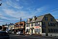
- Anthony Village Historic District: This area along Washington Street and the Pawtuxet River is a historic district, meaning it's a whole neighborhood with many old buildings that tell a story about how people lived and worked long ago.
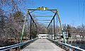
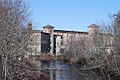
- Arkwright Bridge: This old bridge crosses the Pawtuxet River. It's closed now, but it's a reminder of past transportation and engineering.
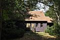
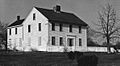
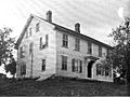
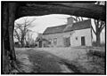
- Isaac Bowen House: Located northeast of Coventry, this house is a historic building that has been around for a long time.
- Joseph Briggs House-Coventry Town Farm: This property on Town Farm Road includes an old house and farm, showing what life was like in the past.
- Christopher Rhodes Greene House: You can find this historic house at 2 Potter Court.
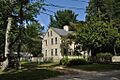
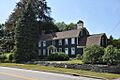
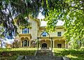
- General Nathanael Greene Homestead: This is a very special place at 20 Taft Street. It's the home of General Nathanael Greene, a hero from the American Revolutionary War. It's so important that it's a National Historic Landmark!
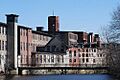
- Harris Mill: This old mill building at 618 Main Street shows the history of manufacturing in the area.
- Interlaken Mill Bridge: Another historic bridge spanning the Pawtuxet River at Arkwright.
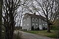
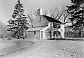
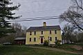
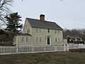
- Paine House: Located on Station Street, this house is a piece of Coventry's history.
- Pawtuxet Valley Dyeing Company: This building at 9 Howard Avenue was once a dyeing company, part of the region's textile industry.
- Read School: This old school building at 1670 Flat River Road reminds us of how education used to be.
- Rice City Historic District: West of Coventry Center, this district includes many historic buildings that show how this village developed.
- South Main Street Historic District: This area on Cady, South Main, and Wood Streets is another historic neighborhood in Coventry.
- Waterman Tavern: Found at 283 Maple Valley Road, this tavern was likely a popular spot for travelers and locals in earlier times.
- William Waterman House: This historic house is located on Rhode Island Route 102.
- Wilson-Winslow House: This old house at 2414 Harkney Hill Road has a long history.
East Greenwich's Historical Highlights
- Armory of the Kentish Guards: Located at Armory and Peirce Streets, this building was used by the Kentish Guards, a military unit with a long history.
- Richard Briggs Farm: This farm at 830 South Road shows what farming life was like in the past.
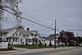
- East Greenwich Historic District: This large area includes many historic buildings and streets, showing the town's rich past. It even extends into Warwick, Rhode Island.
- Fry's Hamlet Historic District: This historic area includes several old properties on South County Trail.
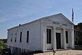
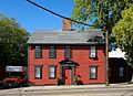
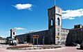
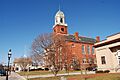
- Kent County Courthouse: Located at 127 Main Street, this building was once the courthouse and is now the East Greenwich Town Hall.
- Massie Wireless Station: You can find this historic wireless station at 1300 Frenchtown Road, part of the New England Wireless and Steam Museum. It's a cool look at early radio technology.
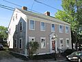
- Spencer–Shippee–Lillbridge House: This historic house is at 12 Middle Road.
- Tillinghast Mill Site: Located in Frenchtown Park, this site has the ruins of an old mill.
- Tillinghast Road Historic District: This road is lined with historic properties, showing the area's development.
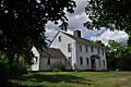
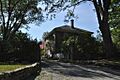
- General James Mitchell Varnum House: At 57 Peirce Street, this house belonged to General James Mitchell Varnum, another important figure from history.
- Clement Weaver-Daniel Howland House: This old house at 125 Howland Road has been around for centuries.
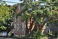
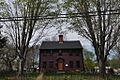
- Colonel Micah Whitmarsh House: This historic house is at 294 Main Street.
- Windmill Cottage: Located at 144 Division Street, this charming cottage has a unique history.
Warwick's Wonderful Landmarks
- Apponaug Historic District: This district on Post Road includes several historic buildings in the Apponaug area.
- John Waterman Arnold House: This historic house is at 11 Roger Williams Avenue.
- Budlong Farm: Located at 595 Buttonwoods Avenue, this is another historic farm property.
- Buttonwoods Beach Historic District: This area near Brush Neck Cove and Greenwich Bay is a historic beach community.
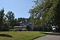
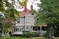
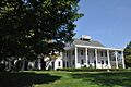
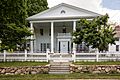
- Cedar Hill: Found at 4157 Post Road, this historic property is now the Clouds Hill Victorian Museum, a great place to see how people lived in the Victorian era.
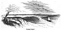
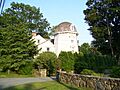
- Conimicut Lighthouse: This lighthouse stands east of Conimicut Point in the Providence River, guiding ships for many years.
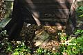
- Cowesett Pound: Located on Cowesett Road, this was historically a place to hold stray animals.
- District Four School: This old school building at 1515 West Shore Road served the community for many years.
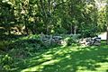
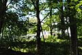
- Elizabeth Spring: This historic spring is off Forge Road.
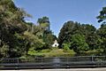
- Forge Farm: At 40 Forge Road, this is a historic farm property.
- Forge Road Historic District: This road from Ives Road to the Potowomut River is a historic area with many old buildings.
- Captain Oliver Gardiner House: This historic house is at 4451 Post Road.
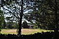
- Gaspee Point: This spot off Namquid Drive is famous for the "Gaspee Affair," an important event leading up to the American Revolution.
- Caleb Gorton House: Located at 987 Greenwich Avenue, this is another historic house.
- Caleb Greene House: This historic house is at 15 Centerville Road.
- Moses Greene House: You can find this historic house at 11 Economy Avenue.
- Peter Greene House: This house is at 1124 West Shore Road.
- Richard Wickes Greene House: Located at 27 Homestead Avenue, this is another Greene family historic home.
- Greene-Bowen House: This historic house is at 698 Buttonwoods Avenue.
- Greene-Durfee House: Located at 1272 West Shore Road, this house also has a long history.
- Greenwich Mills: These old mill buildings at 42 Ladd Street show the industrial past of the area.
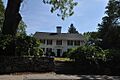
- Hopelands: This historic property on Wampanoag Road is now the campus of the Rocky Hill School.
- Indian Oaks: Located at 836 Warwick Neck Avenue, this is a historic estate.
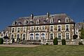
- Knight Estate: This large estate at 486 East Avenue is a historic property.
- Pawtuxet Village Historic District: This district is a charming historic village bounded by several avenues and rivers.
- Pontiac Mills: These old mill buildings on Knight Street were important for manufacturing.
- Rhode Island State Airport Terminal: The old airport terminal at 572 Occupasstuxet Road is a historic building.
- Christopher Rhodes House: This historic house is at 25 Post Road.
- Warwick Civic Center Historic District: This area on Post Road includes important civic buildings.
- Warwick Lighthouse: Located at 1350 Warwick Neck Avenue, this lighthouse helps guide boats in the area.
- John R. Waterman House: This historic house is at 100 Old Homestead Road.
- Oliver A. Wickes House: This historic house is at 794 Major Potter Road.
West Greenwich's Historic Sites
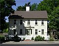
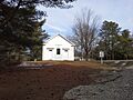
- Stephen Allen House: This historic house is located on Sharp Street.
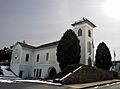
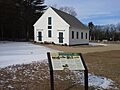
- West Greenwich Baptist Church and Cemetery: This historic church and cemetery are at Plain Meeting House and Liberty Hill Roads in West Greenwich Center.
West Warwick's Notable Places
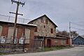
- Centreville Mill: This old mill at 3 Bridal Avenue was an important part of the textile industry.
- Silas Clapp House: Located on East Greenwich Avenue, this is a historic house.
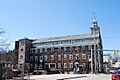
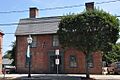
- Crompton Free Library: This building on Main Street was once the free library for the Crompton area.
- Crompton Mill Historic District: This district includes several mill buildings on Remington and Manchester Streets, showing the history of textile production.
- Lippitt Mill: This historic mill at 825 Main Street was another important textile factory.
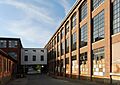
- Royal Mill Complex: Located at 125 Providence Street, this is a large complex of historic mill buildings.
- St. Mary's Church and Cemetery: This historic church and cemetery are on Church Street in Crompton.
- William B. Spencer House: This historic house is at 11 Fairview Avenue.
- Valley Queen Mill: This old mill at 700 Providence Street was also part of the textile industry.
- West Winds: This historic property is at 300 Wakefield Street.
Archaeological Districts and Restricted Sites
Some historic places are archaeological sites, which means they are places where scientists study human history through digging up artifacts. Sometimes, their exact locations are kept secret to protect them.
- Carbuncle Hill Archaeological District, RI-1072-1079: This district in Coventry is an archaeological site.
- Lambert Farm Site, RI-269: An archaeological site in Warwick.
- Meadows Archeological District: Another archaeological district in Warwick.
- Moosup River Site (RI-1153): An archaeological site in Coventry.
- Trafalgar Site, RI-639: An archaeological site in Warwick.
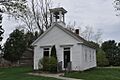
- Hopkins Hollow Village: This historic village, located on Hopkins Hollow Road, Narrow Lane, and Perry Hill Road, spans both Coventry and West Greenwich.
Images for kids
-
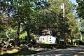
The Stephen Allen House in West Greenwich.
-
Buildings in the Anthony Village Historic District in Coventry.
-
A historic building in the Apponaug Historic District in Warwick.
-
The historic Arkwright Bridge over the Pawtuxet River.
-
The Armory of the Kentish Guards in East Greenwich.
-
The John Waterman Arnold House in Warwick.
-
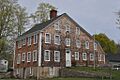
The Isaac Bowen House in Coventry.
-
The Joseph Briggs House-Coventry Town Farm.
-
The Richard Briggs Farm in East Greenwich.
-
Cedar Hill, now the Clouds Hill Victorian Museum in Warwick.
-
The Centreville Mill in West Warwick.
-
The Silas Clapp House in West Warwick.
-
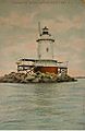
The Conimicut Lighthouse in Warwick.
-
The Cowesett Pound in Warwick.
-
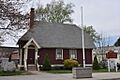
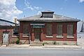
The former Crompton Free Library in West Warwick.
-
Buildings in the Crompton Mill Historic District.
-
A street view of the East Greenwich Historic District.
-
Elizabeth Spring in Warwick.
-
The Forge Farm in Warwick.
-
A view of the Forge Road Historic District.
-

A building in the Fry's Hamlet Historic District.
-
The Captain Oliver Gardiner House in Warwick.
-
Gaspee Point, a historic site in Warwick.
-
The Caleb Gorton House in Warwick.
-
The Caleb Greene House in Warwick.
-
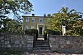
The Christopher Rhodes Greene House in Coventry.
-
The General Nathanael Greene Homestead in Coventry.
-
The Greene-Bowen House in Warwick.
-
The Greenwich Mills in Warwick.
-
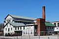
The Harris Mill in Coventry.
-
Hopelands, now the Rocky Hill School campus.
-
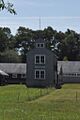
The Hopkins Hollow Church in the Hopkins Hollow Village.
-
Indian Oaks in Warwick.
-
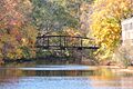
The Interlaken Mill Bridge in Coventry.
-
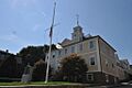
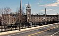
The Kent County Courthouse, now East Greenwich Town Hall.
-
The Knight Estate in Warwick.
-
The Lippitt Mill in West Warwick.
-
The Massie Wireless Station in East Greenwich.
-
The Paine House in Coventry.
-
The Pawtuxet Valley Dyeing Company building.
-
A church in the Pawtuxet Village Historic District.
-
The Pontiac Mills in Warwick.
-

The Read School in Coventry.
-
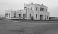
The old Rhode Island State Airport Terminal.
-
The Christopher Rhodes House in Warwick.
-
A school building in the Rice City Historic District.
-
The Royal Mill Complex in West Warwick.
-
St. Mary's Church and Cemetery in West Warwick.
-

A building in the South Main Street Historic District.
-
The William B. Spencer House in West Warwick.
-
The Spencer–Shippee–Lillbridge House.
-
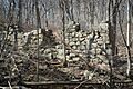
Ruins at the Tillinghast Mill Site.
-
A view of the Tillinghast Road Historic District.
-
The Valley Queen Mill in West Warwick.
-
The General James Mitchell Varnum House.
-
Warwick City Hall in the Warwick Civic Center Historic District.
-
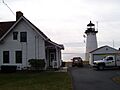
The Warwick Lighthouse.
-
The Waterman Tavern in Coventry.
-
The William Waterman House in Coventry.
-
The Clement Weaver-Daniel Howland House.
-
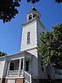
The West Greenwich Baptist Church and Cemetery.
-
The West Winds property in West Warwick.
-
The Colonel Micah Whitmarsh House.
-
The Oliver A. Wickes House.
-
The Wilson-Winslow House in Coventry.
-
The Windmill Cottage in East Greenwich.


