
National Register of Historic Places listings in Lake County, Colorado facts for kids

This article is about the amazing places in Lake County, Colorado that are listed on the National Register of Historic Places. This special list helps protect buildings, sites, and areas that are important to American history. When a place is on this list, it means it has a unique story to tell us about the past.
In Lake County, Colorado, there are nine different places that have earned a spot on this important list. These sites include old mining camps, historic homes, and even a fish hatchery! You can find many of these places near the historic town of Leadville or by the beautiful Twin Lakes.
Contents
What is the National Register of Historic Places?
The National Register of Historic Places is the official list of the nation's historic places worth saving. It's managed by the National Park Service, which is part of the United States government. When a place is added to the Register, it gets special recognition. It also means that people will work to protect it for future generations.
Why are places listed?
Places are listed for many reasons. They might be important because of their history, like where a big event happened. They could also be special because of their architecture or how they were built. Sometimes, they are important because of the people who lived or worked there. Each place tells a part of America's story.
Historic Places in Lake County
Lake County is full of history, especially from the mining boom days. Many of the listed places here are connected to that exciting time. Let's explore some of these fascinating sites.
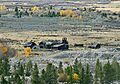
Derry Mining Site Camp
The Derry Mining Site Camp is an old mining area located west of U.S. Highway 24 near Leadville. It was added to the National Register in 2000. This site helps us understand what life was like for miners long ago. It shows how they lived and worked in the mountains.
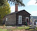
Dexter Cabin and Healy House
The Dexter Cabin and Healy House are two historic homes located at 912 Harrison Avenue in Leadville. Both were listed on the National Register in 1970.
Dexter Cabin
The Dexter Cabin is a small, rustic cabin that belonged to James V. Dexter, a wealthy mining investor. It's a great example of early pioneer living.
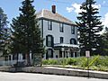
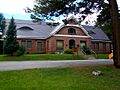
Healy House Museum
Right next to the Dexter Cabin is the Healy House. This beautiful Victorian home was built in 1878. It belonged to August R. Meyer, a mining engineer. Today, both the Dexter Cabin and Healy House are museums. They show how people lived during Leadville's silver boom. You can visit them to see furniture and items from the past.
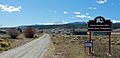
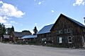
Hayden Ranch Headquarters
The Hayden Ranch Headquarters is another historic site west of U.S. Highway 24, near Leadville. It was listed in 2003. This ranch played a role in the area's agricultural history. It reminds us that not everyone in Lake County was a miner. Some people were ranchers, raising animals and growing food.
Interlaken Resort District
The Interlaken Resort District is a unique area located across Twin Lakes from State Highway 82. It was added to the Register in 1974. This district was once a fancy resort in the late 1800s. People would come here to relax and enjoy the beautiful scenery. Today, you can only reach it by hiking trail. It's like stepping back in time to a forgotten vacation spot.
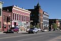
Leadville Historic District
The entire town of Leadville is a National Historic Landmark District. This means it's a very important historic area. It was listed in 1966. Leadville was a booming silver mining town in the late 1800s. Many of its old buildings and streets still look much like they did back then. Walking through Leadville is like walking through history. You can see the old opera house, saloons, and homes that tell stories of the past.
Leadville National Fish Hatchery
The Leadville National Fish Hatchery is located west of Leadville. It was listed in 1980. This hatchery is one of the oldest federal fish hatcheries in the United States. It was built to help stock rivers and lakes with fish. It's an important part of conservation efforts in Colorado.
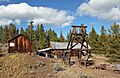
Matchless Mine
The Matchless Mine is located on East 7th Road in Leadville. It was added to the National Register in 2010. This mine is famous because it was owned by Horace Tabor, a very rich and powerful mining king. His second wife, Baby Doe Tabor, lived there for many years after he lost his fortune. The mine is a symbol of the rise and fall of the mining industry.
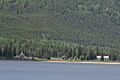
Twin Lakes District
The Twin Lakes District includes areas on both sides of State Highway 82. It was listed in 1974. This district is important for its natural beauty and its history. It includes the Interlaken Resort District and other historic sites around the beautiful Twin Lakes. The lakes themselves are a popular spot for outdoor activities.
Images for kids
-
Derry Mining Camp
-
Dexter Cabin
-
Hayden Ranch Headquarters
-
Healy House
-
Interlaken Resort District
-
Downtown Leadville
-
Leadville National Fish Hatchery
-
Matchless Mine
-
Twin Lakes District


