
National Register of Historic Places listings in Lake County, Montana facts for kids

Have you ever wondered about the old buildings and special places in your town or county? Many of these places have amazing stories to tell about the past! In Lake County, Montana, there are several important spots that are officially recognized for their history. These places are listed on something called the National Register of Historic Places.
Contents
Exploring Lake County's Historic Places
What is the National Register of Historic Places?
The National Register of Historic Places is like a special list kept by the United States government. It includes buildings, sites, districts, structures, and objects that are important in American history, architecture, archaeology, engineering, or culture. When a place is added to this list, it means it's considered worth saving and celebrating for future generations. It helps protect these places and often makes them eligible for special grants to help with their care.
Discovering Lake County's Treasures
Lake County, Montana, is home to 10 unique places that have earned a spot on this important list. Each one tells a part of the county's story, from old schools and banks to historic forts and churches. Let's take a closer look at some of these fascinating sites.
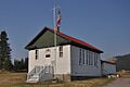
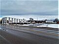
Big Arm School
The Big Arm School is located at 7th and D Streets in Big Arm, Montana. It was added to the National Register on August 16, 2007. This old school building reminds us of how education has changed over the years in small Montana towns.
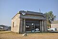
Dayton State Bank
In Dayton, Montana, you can find the Dayton State Bank at 133 C Street. This building became a historic site on October 3, 2012. Old bank buildings often show us the style of architecture from when they were built and how towns grew around their businesses.
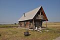
Fort Connah Site
The Fort Connah Site is a very old and important place located near U.S. Route 93 in Post Creek, Montana. It was added to the National Register on April 28, 1982. Fort Connah was a trading post built in the 1840s, making it one of the earliest non-Native American settlements in the area. It played a big role in the fur trade history of Montana.
Kootenai Lodge Historic District
The Kootenai Lodge Historic District is found on Sunburst Drive in Bigfork, Montana. This district was recognized as historic on January 17, 1984. A "historic district" means a group of buildings or an area that has historical importance together, not just one single building.
Frank Bird Linderman House
The Frank Bird Linderman House is located in Lakeside, Montana. It was added to the National Register on February 22, 1984. This house was the lodge of Frank Bird Linderman, a famous writer and politician who lived in Montana. He wrote many books about Native American cultures and the American West.
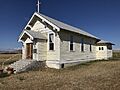
Don E. Olsson House and Garage
In Ronan, Montana, you can find the Don E. Olsson House and Garage at 503 4th Avenue SW. This property was listed on January 15, 2009. It's an example of a historic home and its related buildings from a specific time period.
Polson Feed Mill
The Polson Feed Mill was once located at 501 Main Street in Polson, Montana. It was added to the National Register on April 29, 1980. Sadly, this historic building has since been demolished, but its place on the list reminds us of its past importance to the community.
St. Ignatius Mission
The St. Ignatius Mission is a beautiful and very important site located about 0.1 miles southeast of U.S. Route 93 in St. Ignatius, Montana. It was listed on June 19, 1973. This mission was founded in 1854 and is known for its stunning frescoes (wall paintings) inside the church, painted by a Jesuit brother. It's a significant cultural and religious landmark.
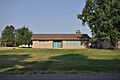
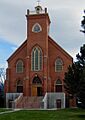
St. Joseph's Catholic Church
St. Joseph's Catholic Church is in the D'Aste Townsite near Moiese, Montana. This church was added to the National Register on March 18, 1999. It stands as a testament to the early communities and their places of worship in the area.
Swan Lake Rock House Historic District
The Swan Lake Rock House Historic District is found off Montana Highway 83 in Swan Lake, Montana. This district was recognized on August 1, 1984. Like the Kootenai Lodge, this district includes several buildings that together tell a story about the history and development of the Swan Lake area.
Images for kids
-
Big Arm School
-
Dayton State Bank
-
Fort Connah Site
-
Don E. Olsson House and Garage
-
Polson Feed Mill (now demolished)
-
St. Ignatius Mission
-
St. Joseph's Catholic Church


_NRHP_80002423_Lake_County,_MT.jpg)
_2002-05.jpg)
_2.jpg)
