
National Register of Historic Places listings in Lava Beds National Monument facts for kids
This article is about the cool historic places you can find in Lava Beds National Monument in California, United States. These special spots are listed on the National Register of Historic Places. Think of it like a list of really important historical sites that are protected!
Lava Beds National Monument is a unique place. It's full of caves, volcanic landscapes, and has a rich history, especially related to the Modoc War. There are ten different places in the park that are on this important list.
Contents
Exploring Historic Sites in Lava Beds National Monument
Lava Beds National Monument is not just about amazing volcanic caves; it's also packed with history. Many of its important sites are recognized nationally. These places tell stories of ancient people, brave warriors, and even early park rangers.
Captain Jack's Stronghold

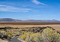
Captain Jack's Stronghold is a famous place south of Tulelake, California. It's a natural fortress made of lava flows. During the Modoc War in 1872-1873, a small group of Modoc people, led by their chief Kintpuash (also known as Captain Jack), used this stronghold to defend themselves against a much larger U.S. Army force. They used the rocky terrain and caves to their advantage. This site was added to the National Register of Historic Places on September 20, 1973. It's a powerful reminder of their courage and the difficult times they faced.
Hospital Rock Army Camp Site

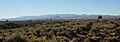
The Hospital Rock Army Camp Site is another important spot south of Tulelake. This was a main camp for the U.S. Army during the Modoc War. It was a key location for their operations. The site was listed on the National Register of Historic Places on October 2, 1973. It helps us understand the military side of the conflict.
Lava Beds National Monument Archeological District
The Lava Beds National Monument Archeological District covers a large area within the park. This district is special because it contains many ancient sites. These sites show evidence of people living here for thousands of years. They include old campsites, tools, and other signs of early human life. This entire district was added to the National Register on March 21, 1991. It helps protect the history of the earliest inhabitants of this land.
Petroglyph Point Archeological Site

Petroglyph Point Archeological Site is a truly amazing place. It's known for its incredible collection of ancient rock carvings, called petroglyphs. These carvings were made by Native American people long ago. They tell stories, record events, or might have been part of ceremonies. The site was listed on the National Register of Historic Places on May 29, 1975. It's a window into the art and culture of the past.
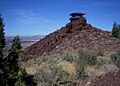
Schonchin Butte Fire Lookout

The Schonchin Butte Fire Lookout is located on top of Schonchin Butte. This lookout tower was built to spot wildfires across the vast landscape. Fire lookouts play a crucial role in protecting forests and parks. This particular lookout was added to the National Register on September 5, 2017. It represents the efforts to preserve the natural beauty of the area from fire.
Thomas-Wright Battle Site
The Thomas-Wright Battle Site is south of Tulelake within the monument. This site marks the location of a significant battle during the Modoc War. It was a fierce fight between the U.S. Army and the Modoc warriors. The site was listed on the National Register of Historic Places on November 15, 1978. It reminds us of the conflicts that shaped the history of this region.
Images for kids
-
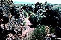
Captain Jack's Stronghold, a natural fortress used by the Modoc people.
-
Hospital Rock, where the U.S. Army set up camp during the Modoc War.
-
A view of Medicine Lake Volcano from Captain Jack's Stronghold.
-
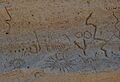
Ancient rock carvings at Petroglyph Point.
-
The Schonchin Butte Fire Lookout, offering wide views of the monument.
