
National Register of Historic Places listings in Leon County, Florida facts for kids

Have you ever wondered about the oldest and most important buildings or places in your community? In Leon County, Florida, there are many special spots that are officially recognized for their history! These places are listed on the National Register of Historic Places. It's like a special club for buildings, areas, and sites that tell important stories about the past of Florida and the United States.
When a place is on this list, it means it's considered very important to our country's history and culture. It also helps protect these places so they can be enjoyed and learned from for many years to come. In Leon County, there are 70 such places, and one of them is even a National Historic Landmark – that's an even higher level of importance! A few places were once on the list but were later removed, usually because they changed too much or were no longer there.
Cool Historic Places in Leon County
Let's explore some of the amazing historic places you can find in Leon County! Each one has a unique story to tell.
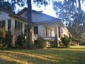
Averitt-Winchester House

The Averitt-Winchester House is a beautiful old home located in Miccosukee, Florida. It was added to the National Register in 1996. Imagine living in a house that's been around for so long! It helps us remember what homes looked like in the past.
Bannerman Plantation

The Bannerman Plantation, located in Tallahassee, Florida, became a historic site in 2002. Plantations were large farms in the past, and this one is part of a bigger group of historic rural places in Leon County. It helps us understand the history of farming and life in this area long ago.
Bellevue Plantation

Another plantation, Bellevue, is also near Tallahassee. It was added to the list way back in 1971! These old plantations are important because they show us how people lived and worked in Florida many years ago.
Billingsley Farm

Billingsley Farm, listed in 2007, is another example of a historic farm in Tallahassee. Farms like this played a huge role in feeding communities and shaping the economy of early Florida.
Blackwood-Harwood Plantations Cemetery

This cemetery, added in 1999, is a quiet place that tells a lot about the people who lived and worked on the Blackwood and Harwood Plantations. Cemeteries can be important historical sites because they show us who lived in an area and how they were remembered.
Bradley's Country Store

Bradley's Country Store is a truly unique spot in Tallahassee, listed in 1984. It's not just a store; it's a piece of history! Imagine a place where people have been buying their goods and meeting up for decades. It shows us what local businesses were like in the past.
Caroline Brevard Grammar School

Schools are important parts of history too! The Caroline Brevard Grammar School in Tallahassee, listed in 1987, reminds us of how education has changed over time. This building once taught many students who grew up to shape the community.
Brokaw-McDougall House

The Brokaw-McDougall House, added in 1972, is another beautiful historic home in Tallahassee. Homes like this show us the different styles of architecture and how families lived in earlier times.
Calhoun Street Historic District

A "Historic District" means a whole area or neighborhood is considered historic, not just one building. The Calhoun Street Historic District in Tallahassee, listed in 1979, is a great example. Walking through it is like stepping back in time, with many old buildings that keep their original look and feel.
Carnegie Library at FAMU

Libraries are super important for learning! The Carnegie Library at Florida A&M University (FAMU) was listed in 1978. Andrew Carnegie, a famous businessman, helped build many libraries across the country, and this one is a part of that legacy.
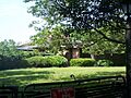
Cascades Park
,_Smokey_Hollow_Pond_from_parking_garage.JPG)
Cascades Park in Tallahassee, listed in 1971, is more than just a park. It has a long history, and its natural features and past uses make it a significant place. It's a great example of how natural spaces can also be historic.
Chaires Community Historic District

The Chaires Community Historic District, listed in 2000, highlights a whole community's history in Chaires, Florida. It includes several important buildings that show how this community grew and developed.
The Columns

"The Columns" is a grand building in Tallahassee, listed in 1975. Its name comes from the large columns that are part of its design. Buildings with unique architecture often become historic landmarks.
Covington House

The Covington House in Tallahassee, listed in 1989, is another example of a well-preserved historic home. It helps us understand the different styles of homes built in the area over the years.
Exchange Bank Building

The Exchange Bank Building in Tallahassee, listed in 1984, shows us what important businesses looked like in the past. Banks were central to the economy, and their buildings often had impressive designs.
First Presbyterian Church

Churches often play a big role in a community's history. The First Presbyterian Church in Tallahassee, listed in 1974, is a beautiful example of a historic place of worship that has served its community for many years.
Florida A&M University Historic District

Like the Chaires district, the Florida Agricultural and Mechanical College Historic District, listed in 1996, recognizes the historical importance of the entire Florida A&M University campus. This university has a rich history and has been a vital part of education in Florida for a long time.
Florida Governor's Mansion

The Florida Governor's Mansion in Tallahassee, listed in 2006, is where Florida's governors live. It's a very important building because it's the official home of the state's leader and has seen many important events.
Florida State Capitol

The Florida State Capitol building in Tallahassee, listed in 1973, is where the state's laws are made. This old building is a symbol of Florida's government and history.
Goodwood Plantation

Goodwood Plantation in Tallahassee, listed in 1972, is another significant plantation. Today, it's a museum and park, allowing visitors to learn about its past and enjoy its beautiful grounds.
Greenwood Cemetery

Greenwood Cemetery in Tallahassee, listed in 2003, is a historic burial ground. It's a place where many important people from Tallahassee's past are laid to rest, and it tells a lot about the community's history.
The Grove Plantation

The Grove Plantation, listed in 1972, is another historic plantation in Tallahassee. These sites are important for understanding the agricultural history of Florida.
Jacksonville, Pensacola and Mobile Railroad Company Freight Depot

This old freight depot in Tallahassee, listed in 1997, was once a busy place where goods were loaded and unloaded from trains. It reminds us of the importance of railroads in connecting communities and moving goods in the past. Today, it's the Amtrak station.
Lake Jackson Mounds

The Lake Jackson Mounds, listed in 1971, are ancient mounds built by Native American people long ago. These sites are incredibly important for understanding the very early history and cultures of Florida.
Leon High School

Leon High School in Tallahassee, listed in 1993, is another example of a historic school building. It has been a center of education for many generations of students.
Lichgate on High Road

Lichgate on High Road, listed in 2006, is a charming and unique historic property in Tallahassee. It's known for its beautiful gardens and a special gate called a "lichgate."
Los Robles Gate

The Los Robles Gate in Tallahassee, listed in 1989, is a grand entrance that marks a historic neighborhood. Gates like this often tell us about the style and design of communities from a different era.
Magnolia Heights Historic District

The Magnolia Heights Historic District in Tallahassee, listed in 1984, is another neighborhood recognized for its historic homes and overall character. It's a great place to see different styles of older houses.
Meridian Road

Even a road can be historic! Meridian Road, listed in 2013, is recognized for its historical significance. Roads often follow old paths and can tell us about how people traveled and settled in an area.
Miccosukee Methodist Church

The Miccosukee Methodist Church, listed in 1996, is a historic church in Miccosukee. It has been a gathering place for the community for many years.
Natural Bridge Battlefield

The Natural Bridge Battlefield, listed in 1970, is a very important historical site near Woodville, Florida. It was the location of a significant battle during the American Civil War. Learning about battlefields helps us understand major events in our country's past.
Old City Waterworks

The Old City Waterworks in Tallahassee, listed in 1979, was once essential for providing water to the city. It shows us how cities developed and how important infrastructure was built.
Old Fort Braden School

The Old Fort Braden School, listed in 1994, is another historic school building. It's located west of Tallahassee and reminds us of the history of education in rural areas.
Park Avenue Historic District

The Park Avenue Historic District in Tallahassee, listed in 1979, is a beautiful area with many historic homes and buildings. It's a popular place for walking and enjoying the city's past.
Pisgah United Methodist Church

The Pisgah United Methodist Church, listed in 1974, is another historic church in Leon County. These old churches often have unique architecture and long histories of serving their communities.
John Gilmore Riley House

The John Gilmore Riley House in Tallahassee, listed in 1978, is important because it belonged to a significant African American educator and community leader. It helps tell the story of civil rights and education in Florida.
Roberts Farm Historic and Archeological District

The Roberts Farm Historic and Archeological District, listed in 1995, is special because it includes both historic farm buildings and archaeological sites. This means it has clues about people who lived there even before the farm was built!
Rollins House

The Rollins House in Tallahassee, listed in 2001, is another historic home that helps us understand the different types of residences built in the area.
St. John's Episcopal Church

St. John's Episcopal Church in Tallahassee, listed in 1978, is a prominent historic church in the city. Its architecture and long history make it a significant landmark.
Mission San Luis de Apalachee

Mission San Luis de Apalachee, listed in 1966, is a truly amazing place! It's an archaeological site that was once a Spanish mission and a village of the Apalachee people. It's so important that it's a National Historic Landmark. You can visit and see reconstructed buildings that show what life was like there hundreds of years ago.
San Pedro y San Pablo de Patale

San Pedro y San Pablo de Patale, listed in 1972, is another historic mission site east of Tallahassee. These mission sites are crucial for understanding the early interactions between Native Americans and European settlers in Florida.
Smoky Hollow Historic District

The Smoky Hollow Historic District in Tallahassee, listed in 2000, was once a vibrant African American community. It's important for remembering the history and contributions of this community to Tallahassee.
Strickland-Herold House

The Strickland-Herold House in Miccosukee, listed in 1997, is another historic home that adds to the rich history of the area.
Tall Timbers Research Station and Land Conservancy

Tall Timbers Research Station, listed in 1989, is not just a historic place but also an important center for studying nature and conservation. It shows how historic properties can also be used for modern research.
Tallahassee Historic District Zones I And II
This large historic district, listed in 1972, covers a significant part of downtown Tallahassee. It includes many important government buildings, homes, and businesses that tell the story of the city's growth.
Union Bank

The Union Bank building in Tallahassee, listed in 1971, is one of the oldest bank buildings in Florida. It's a great example of early commercial architecture.
Van Brunt House

The Van Brunt House in Miccosukee, listed in 1997, is another historic home that helps preserve the architectural heritage of the area.
David S. Walker Library

The David S. Walker Library in Tallahassee, listed in 1976, is a historic library building. Libraries are often central to a community's intellectual and social life.
Williams House

The Williams House in Tallahassee, listed in 1996, is another historic home that contributes to the city's rich architectural history.
Woman's Club of Tallahassee

The Woman's Club of Tallahassee, listed in 1987, is a historic building that was home to an important women's organization. It tells the story of women's roles in community development and social change.
Woman's Working Band House

The Woman's Working Band House in Tallahassee, listed in 2010, is another significant site related to women's history and community efforts.
Places No Longer on the List
Sometimes, a historic place might be removed, or "delisted," from the National Register. This usually happens if the building is changed too much, or if it's no longer standing.
Hotel Floridan
The Hotel Floridan in Tallahassee was once a historic hotel, listed in 1979. However, it was delisted in 1982.
Johnson-Caldwell House
The Johnson-Caldwell House in Tallahassee was also once on the list, from 1979 to 1989.
These historic places in Leon County are like treasures that help us understand the past and appreciate the unique history of Florida!
Images for kids
-

Some historic places have restricted addresses for privacy or protection.
-
The Sollner-Wall House.
-
The Taylor House in Tallahassee.
-
The Winterle House.


