
National Register of Historic Places listings in Lincoln County, South Dakota facts for kids

Welcome to Lincoln County, South Dakota! This page is all about special places in the county that are listed on the National Register of Historic Places. Think of it like a Hall of Fame for buildings, sites, and objects that are important to American history, architecture, archaeology, engineering, or culture. When a place is on this list, it means it's recognized as a valuable part of our past and should be protected for future generations to enjoy.
In Lincoln County, there are 27 amazing places on this list. One of them is even a super important National Historic Landmark! We'll explore some of these cool spots and learn why they matter.
Contents
What is the National Register of Historic Places?
The National Register of Historic Places is the official list of the nation's historic places worthy of preservation. It's managed by the National Park Service, which is part of the U.S. government. Being on the Register helps protect these places and makes people more aware of their importance. It also helps with getting grants or tax benefits for restoring and keeping these historic sites safe.
Important Historic Sites in Lincoln County
Lincoln County is home to many places that tell stories about the past. Let's look at some of the most interesting ones.
Blood Run Site: A National Historic Landmark
The most important site in Lincoln County on the National Register is the Blood Run Site. It's so special that it's also a National Historic Landmark! This means it's one of the most important historic places in the entire country.
The Blood Run Site is a huge archaeological area located along the Big Sioux River, right on the border between South Dakota and Iowa. It was a major settlement and trading center for Native American groups, especially the Oneota culture, between about 1300 and 1700 AD.
Archaeologists have found many things here, including burial mounds, village areas, and tools. It shows how large communities lived, traded, and interacted long before European settlers arrived. It's a powerful reminder of the rich history of the Native American people in this region.

Historic Homes and Buildings
Many of the places on the National Register in Lincoln County are historic homes and buildings that show us how people lived and worked in the past.
Dr. Andrew Anderson House
The Dr. Andrew Anderson House in Canton is a beautiful home built in 1903. It's a great example of early 20th-century architecture and tells us about the people who helped build the community.
Magnus O. Bergstrom House
Also in Canton, the Magnus O. Bergstrom House was built in 1893. It's another example of the grand homes from that era, showing the style and craftsmanship of the time.
Byrnes House
The Byrnes House in Canton, built around 1900, is a lovely example of Queen Anne style architecture. These homes often have unique towers, turrets, and decorative details.

John Isakson House
The John Isakson House, built in 1888, is another significant home in Canton. It represents the homes of early settlers and important community members.
C. B. Kennedy Mansion
The C. B. Kennedy Mansion in Canton, built in 1901, is a large and impressive house. It shows the wealth and architectural tastes of prominent citizens from over a century ago.
Rudolph-Parke House
The Rudolph-Parke House in Canton, built in 1890, is a well-preserved home that gives us a peek into the late 19th-century lifestyle.
Skartvedt House
The Skartvedt House in Canton, built in 1897, is another example of a historic residence that has been recognized for its importance.
J. W. Taylor House
The J. W. Taylor House in Canton, built in 1900, is a historic home that adds to the collection of well-preserved buildings in the city.
Community and Public Buildings
Beyond homes, other buildings that served the community are also on the list.
Canton Carnegie Library
The Canton Carnegie Library was built in 1905 with money from famous businessman Andrew Carnegie. Many towns across the U.S. have Carnegie Libraries, which were built to help communities access books and learning.
Canton Lutheran Church
The Canton Lutheran Church, built in 1902, is an important religious building in the community. Churches often serve as central gathering places and have beautiful architecture.

Harney Hospital
The Harney Hospital in Lennox, built in 1902, was an important medical facility in its time. It shows the history of healthcare in the region.
Old Main, Augustana Academy
Old Main at the former Augustana Academy in Canton, built in 1888, was a key building for education. It was part of a school that played a big role in the lives of many students.

Unique Historical Sites
Some listings are not just buildings but unique sites that tell a special story.
Canton Asylum for American Indians Cemetery
The Canton Asylum for American Indians Cemetery is a very important historical site in Canton. It's the burial ground for at least 121 people who were patients at the Canton Asylum for American Indians, which operated from 1898 to 1934. This cemetery helps us remember the lives of those who were cared for at the asylum.
Brooklyn School District No. 42
The Brooklyn School District No. 42 building in Beresford, built in 1904, is an old schoolhouse. These buildings are important because they show how education was provided in rural areas long ago.
Grand Valley Schoolhouse, District No. 12
Another historic schoolhouse, the Grand Valley Schoolhouse, District No. 12, near Canton, was built in 1903. It's another example of the small, one-room schoolhouses that were once common.
Hudson Boy Scout Cabin
The Hudson Boy Scout Cabin in Hudson, built in 1936, is a unique listing. It shows the history of youth organizations like the Boy Scouts and their role in the community.
Norway Center Store
The Norway Center Store near Hudson, built in 1902, was a general store that served a rural community. These stores were often the heart of small towns, where people bought supplies and gathered.
South Dakota Dept of Trans. Bridge No. 42-200-125
This bridge near Canton, built in 1908, is listed for its engineering and historical significance. Bridges are often overlooked, but they are vital parts of our infrastructure and history.
Farms and Rural Properties
Lincoln County also has historic farms and rural properties that show the agricultural heritage of the area.
Anthon W. Elster House
The Anthon W. Elster House near Canton, built in 1906, is an example of a historic farmhouse.
Hansen-Hagedorn Barn
The Hansen-Hagedorn Barn near Tea, built in 1915, is a historic barn. Barns are important structures that show the history of farming and agriculture.
Mathias Schmid Farm
The Mathias Schmid Farm near Beresford, established in 1900, is a historic farm district. It includes several buildings that together tell the story of farming life.
Peder and Helga Tuntland Farmstead
The Peder and Helga Tuntland Farmstead near Beresford, established in 1900, is another important historic farm. It shows the layout and buildings of a typical farm from that period.
Ulrickson Barn
The Ulrickson Barn near Hudson, built in 1915, is another example of a historic barn recognized for its architectural and historical value.
Former Listings
Sometimes, places are removed from the National Register. This usually happens if they are destroyed or changed so much that they no longer have their historic value.
Kruger Dam
The Kruger Dam near Canton was once on the list but was removed in 2012.
South Dakota Department of Transportation Bridge No. 42-103-207
This bridge near Beresford was also removed from the list in 2008.
These historic places in Lincoln County help us understand the past and appreciate the stories of the people who lived here before us. They are important reminders of our shared heritage!
Images for kids
-
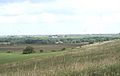
A view of the Blood Run Site in South Dakota.
-
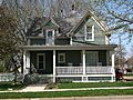
The historic Byrnes House in Canton.
-
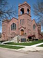
The historic Canton Lutheran Church.
-
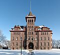
Old Main at the former Augustana Academy.
