
National Register of Historic Places listings in Lonoke County, Arkansas facts for kids

Have you ever wondered about really old buildings or places that have a special story? In Lonoke County, Arkansas, there are many such spots! These places are so important that they are listed on something called the National Register of Historic Places. It's like a special list kept by the United States government to protect and celebrate buildings, sites, and objects that are important to our country's history.
When a place is on this list, it means it's recognized for its unique history, amazing architecture, or special meaning to a community. It helps make sure these treasures are preserved for people like you to learn about and enjoy for many years to come. Lonoke County has 34 places on this list, and one of them is even a super-important "National Historic Landmark"! Let's explore some of these cool historic sites.
Discovering Lonoke County's Historic Treasures
Lonoke County is home to many fascinating places that tell stories from the past. From ancient Native American sites to old train stations and beautiful historic homes, each spot has something special to share.
Ancient History: Mounds and Early Life
What are the Toltec Mounds?
One of the most important places in Lonoke County is the Toltec Mounds Archeological State Park. This isn't just any park; it's a "National Historic Landmark"! Long, long ago, Native American people built large earth mounds here. These mounds were used for special ceremonies and as homes for important leaders. Imagine people living here over 1,000 years ago! The park helps us learn about their lives and culture.
Exploring the Coy Mound Site
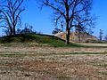
Another ancient spot is the Coy Mound Site. Like the Toltec Mounds, this site also has earth mounds built by early Native American groups. It's located near the Indian-Bakers Bayou, showing how important rivers and water were to these ancient communities. These mounds are like giant puzzles that archaeologists study to understand how people lived thousands of years ago.
Buildings with Big Stories
Houses from the Past
Many old houses in Lonoke County are on the National Register. These homes show us how people lived in different times and what kind of styles were popular.
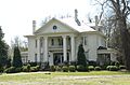
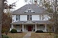
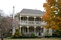
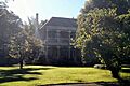
- The Ashley-Alexander House is a beautiful old home located north of Scott. It gives us a peek into what homes looked like in the past.
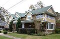
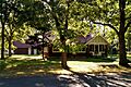
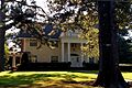
- The Thomas Sloan Boyd House and the Eagle House, both in Lonoke, are other examples of historic homes. They have unique designs and stories from the families who lived there.
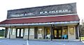
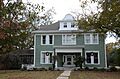
- Other notable homes include the W.P. Fletcher House, Shull House, Trimble House, Trimble-McCrary House, Walls House, and Wheat House. Each one has its own history and architectural style.
Train Stations: Hubs of Activity
Before cars were common, trains were a huge part of travel and trade. Train stations, or depots, were busy places!
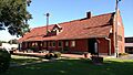
- The Carlisle Rock Island Depot in Carlisle was once a lively train station. It was where people would arrive and depart, and goods would be shipped.
- The Rock Island Depot in Lonoke also played a big role in connecting the town to other places. These depots remind us of a time when trains were king!
Community and Education Buildings
- The Carver Gymnasium in Lonoke is an important building for the community's history. Gyms are often places where people gather for sports, events, and learning.
- The Woodlawn School Building near Woodlawn is another historic site. Old school buildings often hold many memories of students and teachers from long ago.
Important Public Buildings
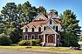
- The Lonoke County Courthouse is a very important building in Lonoke. Courthouses are where local government happens, and they often have grand designs. This one has been a central part of the county's life for many years.
Remembering History: Cemeteries and Monuments
Camp Nelson Confederate Cemetery
The Camp Nelson Confederate Cemetery near Cabot is a place that remembers soldiers from the American Civil War. Cemeteries like this help us understand and honor the past, especially difficult times in history.
Lonoke Confederate Monument
On the courthouse lawn in Lonoke, you'll find the Lonoke Confederate Monument. Monuments are built to remember important events or people. This one is a reminder of the Civil War and its impact on the area.
Historic Districts and Roads
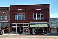
Keo Commercial Historic District
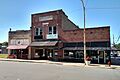
The Keo Commercial Historic District in Keo is not just one building, but a whole area! It includes Main and Fleming Streets. This district shows us what a busy town center looked like in the past, especially how cotton and rice farming shaped the area.
Lonoke Downtown Historic District
Similar to Keo, the Lonoke Downtown Historic District includes several historic buildings around Front and Center Streets. This area shows how the town of Lonoke grew and developed over time.
Memphis to Little Rock Road Segments
Some parts of old roads are also considered historic! The Memphis to Little Rock Road-Bayou Two Prairie Segment and the Memphis to Little Rock Road-Brownsville Segment are special because they were part of the Trail of Tears. This was a very sad time in history when many Native American people were forced to move from their homes. These road segments help us remember that difficult journey.
US 70, Union Valley Segment
Another historic road segment is the US 70, Union Valley Segment. Old roads can tell us about how people traveled and how towns were connected in the past.
Other Interesting Sites
- The Dortch Plantation near Scott is another significant historical site, showing the history of farming and large estates in the region.
- The Sears House in Austin is a unique home, possibly built from a kit purchased from the Sears catalog, which was a popular way to build houses long ago!
- The Dr. E.F. Utley House in Cabot is another example of a historic residence that adds to the rich history of the county.
Former Listing
Sometimes, a place might be removed from the National Register if it's no longer there or if its historical importance changes. One such place was the St. Louis Southwest Railway (Cotton Belt Route) Depot in Coy. It was once a historic train station but has since been removed from the list.
Images for kids
-
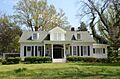
The historic Ashley-Alexander House.
-
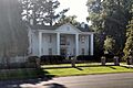
The Thomas Sloan Boyd House in Lonoke.
-
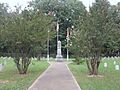
The entrance to Camp Nelson Confederate Cemetery.
-
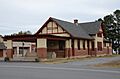
The old Carlisle Rock Island Depot.
-

A view of the Coy Mound Site.
-
Part of the historic Dortch Plantation.
-
The Eagle House in Lonoke.
-
The Joe P. Eagle and D. R. Boone Building.
-
The First Christian Church in Lonoke.
-

The First Presbyterian Church in Lonoke.
-
The W.P. Fletcher House.
-
Buildings in the Keo Commercial Historic District.
-
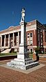
The Lonoke Confederate Monument.
-

The Lonoke County Courthouse.
-
A street view in the Lonoke Downtown Historic District.
-
The Rock Island Depot in Lonoke.
-

The Sears House in Austin.
-
The Shull House in Lonoke.
-
One of the ancient Toltec Mounds.
-
The Trimble House in Lonoke.
-
The Trimble-McCrary House.
-

A segment of U.S. Route 70 in Union Valley.
-

The Dr. E.F. Utley House in Cabot.
-
The Walls House in Lonoke.
-
The Wheat House in Lonoke.
-
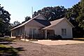
The Woodlawn School Building.


