
National Register of Historic Places listings in Madison County, Mississippi facts for kids

Welcome to Madison County, Mississippi! This article is all about special places here that are listed on the National Register of Historic Places. This is like a national list of important buildings, sites, and areas that have a lot of history. They are worth protecting and remembering.
In Madison County, there are 31 places on this important list. These places tell us stories about the past, from old homes and schools to ancient Native American sites and parts of famous trails. Let's explore some of them!
Historic Homes and Buildings
Madison County has many beautiful and historic buildings. These places often show us how people lived long ago.
John W. Boddie House

The John W. Boddie House is located on the campus of Tougaloo College in Tougaloo. It was added to the National Register in 1982. Tougaloo College itself is also a historic district on the Register. This shows how important the college and its buildings are to history.
Chapel of the Cross

About six miles northwest of where Interstate 55 and Mississippi Highway 463 meet, you'll find the Chapel of the Cross. This historic church in Mannsdale was listed in 1972. It's a peaceful and very old building that has seen many years of history.
Madison County Jail

The old Madison County Jail is located at 234 East Fulton Street in Canton. It was added to the National Register in 1979. Even a jail can be historic! This building tells us about the justice system and architecture of its time.
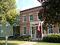
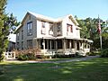
Montgomery House

The Montgomery House is on Main Street in Madison. It became a historic place in 1984. This house is a great example of the homes built in the area many years ago.
Sedgewood Plantation

Sedgewood Plantation, at 2607 Virlilia Road in Canton, was added to the National Register in 2000. Plantations like Sedgewood are important for understanding the agricultural history of Mississippi.
Charles F. Smith House

The Charles F. Smith House is at 140 Semmes Avenue in Canton. It was listed in 1994. This house is another example of the unique architecture and family histories found in Madison County.
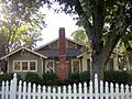
Strawberry Patch-McKay House

On Old Canton Road in Madison, you'll find the Strawberry Patch-McKay House. This home was recognized as historic in 1986. It's a reminder of the older homes that once dotted the landscape of Madison.
Young House

The Young House, located at 3463 North Liberty Street in Canton, was added to the National Register in 2008. It's one of the more recently listed historic homes, showing that important history is still being recognized.
Historic Districts and Sites
Some places are important not just for one building, but for a whole area or for what happened there. These are called historic districts or sites.
Canton Courthouse Square Historic District

The heart of Canton, around Center, Liberty, Peace, and Union Streets, is a historic district. This area, including the beautiful Madison County Courthouse, was listed in 1982. It's where many important events and daily life happened in Canton's past.
East Canton Historic District
Another important area is the East Canton Historic District. This district includes streets like East Academy, East Center, East Fulton, Lyons, Madison, East Peace, and Priestly Streets. It was added to the Register in 1998, showing the historical importance of this part of the city.
Dorroh Street Historic District
In Madison, the Dorroh Street Historic District includes numbers 103, 105, and 115 Dorroh Street. This small district was recognized in 1986. It helps preserve the look and feel of an older neighborhood.
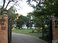
Tougaloo College Historic District
The entire campus of Tougaloo College in Tougaloo is a historic district. It was listed in 1998. Tougaloo College has a very rich history, especially in education and civil rights, making its campus a truly special place.
Ancient Sites and Trails
Madison County is also home to very old sites, including Native American mounds and parts of famous historic trails.
Boyd Mounds Site

The Boyd Mounds Site (also known as 22MD512) is a fascinating place located at Mile 106.9 on the Natchez Trace Parkway. This site has six ancient mounds built by Native Americans long ago. It was added to the National Register in 1989 and is open for visitors to explore.
Old Natchez Trace and Choctaw Agency Site
A significant part of the historic Natchez Trace is found in Madison County. This section, located between Interstate 55 and Livingston Road, west of Ridgeland, was listed in 1995. It includes a 3.3-mile part of the old trail. It also has an archaeological site where a government agency for the Choctaw people was located from 1811 to 1823. This site tells us about the history of Native Americans and early American interactions.
Old Natchez Trace (170-30)

Another part of the Old Natchez Trace, specifically at Natchez Trace Parkway milepost 104.6, east of Ridgeland, was listed in 1976. These preserved segments of the trail allow us to imagine what travel was like hundreds of years ago.
Doak's Stand Treaty Site
The Doak's Stand Treaty Site is located along Sulphur Springs Road, northeast of Canton. This site was added to the National Register in 1978. It's important because it's where the Treaty of Doak's Stand was signed in 1820 between the United States and the Choctaw Nation. This treaty involved a large land exchange.
Other Notable Historic Places
There are many other interesting places on the National Register in Madison County.
Canton Cemetery
The Canton Cemetery, on South Lyon Street in Canton, was listed in 2015. Cemeteries are often historic because they contain the graves of important people and show the history of a community.
Canton High School

The Canton High School building, at 3380 North Liberty Street in Canton, was added to the Register in 1998. This shows the importance of education and the history of schools in the area.
Fairview School
The Fairview School, at 1278 North Old Canton Road in Canton, became a historic site in 2009. It's another example of a school building that played a big role in the community's past.
Madison-Ridgeland Public School

The Madison-Ridgeland Public School on Montgomery Street in Madison was listed in 1986. This building served many students over the years and is a key part of the area's educational history.
Mississippi Institute of Aeronautics Aircraft Hangars

At Bruce Campbell Field, 7496 Old Canton Road in Madison, you'll find the Mississippi Institute of Aeronautics Aircraft Hangars. These hangars were listed in 2005. They are important for understanding the history of aviation and flight training in Mississippi.
Mt. Zion Baptist Church
The Mt. Zion Baptist Church, at 514 West North Street in Canton, was added to the National Register in 2000. Historic churches are often central to a community's social and spiritual life.
Yazoo & Mississippi Valley Railroad Depot
The Yazoo & Mississippi Valley Railroad Depot is on Vernon Street in Flora, between the Illinois Central railroad tracks and Main Street. This old train station was listed in 1995. Railroad depots are important because they were once busy hubs for travel and trade.
Images for kids
-

The Boyd Mounds Site along the Natchez Trace Parkway.
-

The Madison County Courthouse, part of the historic district.
-
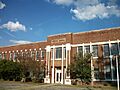
Canton High School, a historic educational building.
-
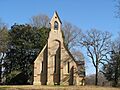
The beautiful Chapel of the Cross near Mannsdale.
-
The old Madison County Jail in Canton.
-
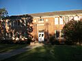
The historic Madison-Ridgeland Public School.
-

Historic aircraft hangars at Bruce Campbell Field.
-
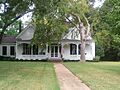
The historic Montgomery House in Madison.
-
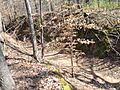
A preserved section of the Old Natchez Trace.
-
Sedgewood Plantation, a historic home in Canton.
-
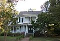
The Charles F. Smith House in Canton.
-
The Strawberry Patch-McKay House on Old Canton Road.
-
The Young House in Canton, Mississippi.
