
National Register of Historic Places listings in Marlboro County, South Carolina facts for kids

This page lists special places in Marlboro County, South Carolina, that are part of the National Register of Historic Places. Think of the National Register as an official list of buildings, sites, and objects across the United States that are important to our country's history. When a place is on this list, it means it's recognized for its unique past and is worth protecting for future generations.
There are 10 amazing properties and areas in Marlboro County that have made it onto this important list. Each one tells a part of South Carolina's story!
Contents
What is the National Register of Historic Places?
The National Register of Historic Places is like a special hall of fame for historic sites. It's managed by the National Park Service, which is part of the U.S. government. Its main goal is to help people understand and protect places that are important to American history, architecture, archaeology, engineering, and culture.
Why are these places important?
When a building or area is added to the National Register, it gets special recognition. This helps people appreciate its history and often makes it easier to get help to preserve it. It's a way to make sure these valuable parts of our past don't get lost. These places might be old homes, churches, farms, or even whole neighborhoods that show us how people lived long ago.
Historic Places in Marlboro County
Here are some of the interesting places in Marlboro County that are listed on the National Register of Historic Places:
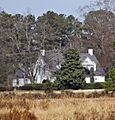
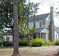
Appin
- Location: Near Bennettsville
- Listed: June 28, 1982
Appin is a historic property located just outside Bennettsville. It's a great example of the kind of old homes that tell us about life in the past.
Bennettsville Historic District
- Location: Main Street area in Bennettsville
- Listed: April 20, 1978
This isn't just one building; it's a whole area in the heart of Bennettsville! A historic district means that many buildings in that neighborhood are important together. Walking through this district is like taking a step back in time to see how the town grew.
Clio Historic District
- Location: Along South Carolina Highways 9 and 381 in Clio
- Listed: July 16, 1979
Just like Bennettsville, the town of Clio also has a historic district. This area includes several buildings that show the history and development of Clio.
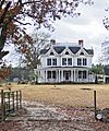
Jennings-Brown House
- Location: 121 S. Marlboro Street, Bennettsville
- Listed: February 23, 1972
This house is a specific historic home in Bennettsville. It was one of the first individual properties in Marlboro County to be added to the National Register.
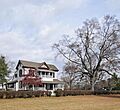
Magnolia
- Location: 508 E. Main Street, Bennettsville
- Listed: March 14, 1973
Another beautiful historic house in Bennettsville, Magnolia is a significant landmark that adds to the town's rich history.
Manship Farmstead
- Location: 2601 Manship Road, Tatum
- Listed: June 4, 1997
This farmstead in Tatum gives us a look into the agricultural history of the area. It shows how farms were set up and operated in the past.
McLaurin House
- Location: East of Clio on South Carolina Highway 40
- Listed: March 24, 1978
The McLaurin House is another important historic home located near Clio. It's a great example of the architecture from its time.
McLaurin-Roper-McColl Farmstead
- Location: 1104 Laurin Willis Road, Clio
- Listed: January 20, 2012
This is another farmstead that has been recognized for its historical value. It helps us understand the farming traditions and family histories in the Clio area.
Pegues Place
- Location: North of Wallace, off U.S. Route 1
- Listed: January 25, 1971
Pegues Place is a historic site located near Wallace. It was one of the very first places in Marlboro County to be listed on the National Register.
Robertson-Easterling-McLaurin House
- Location: West of Bennettsville off South Carolina Highway 912
- Listed: April 5, 1984
This house near Bennettsville is another example of a well-preserved historic home that tells a story about the people who lived there and the history of the region.
Images for kids
-
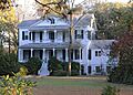
Appin
-

Marlboro Courthouse, part of the Bennettsville Historic District
-
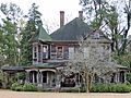
Sternberger-Welch-Hamer House in the Clio Historic District
-
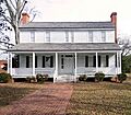
Jennings-Brown House
-
Magnolia
-
Manship Farmstead
-
McLaurin House
-
McLaurin-Roper-McColl Farmstead
-
Pegues Place
-
Robertson-Easterling-McLaurin House


