
National Register of Historic Places listings in McHenry County, North Dakota facts for kids

Welcome to McHenry County, North Dakota! Did you know that this county is home to some really old and special places? These places are so important that they are listed on something called the National Register of Historic Places.
The National Register of Historic Places is like a special list kept by the United States government. It helps to protect buildings, sites, objects, structures, and districts that are important in American history, architecture, archaeology, engineering, or culture. When a place is on this list, it means it's recognized as a valuable part of our past.
In McHenry County, there are 12 different places that have made it onto this important list. Each one tells a unique story about the county's history. Let's explore some of them!
Contents
- Historic Places in McHenry County
- Denbigh Station and Experimental Forest
- Elliott Bridge
- Granville State Bank
- Hotel Berry
- Liberty Baptist Church
- Lower Souris National Wildlife Refuge Airplane Hangar
- McHenry County Courthouse
- Norway Lutheran Church and Cemetery
- Old Saint John Nepomocene Cemetery, Wrought-Iron Cross Site
- Old Saints Peter and Paul Cemetery, Wrought-Iron Cross Site
- Alfred and Clara Sevareid House
- Westgaard Bridge
- Images for kids
Historic Places in McHenry County
Denbigh Station and Experimental Forest
This historic site is located near U.S. Route 2 in Denbigh. It was added to the National Register on June 24, 2010. The Denbigh Experimental Forest was a special place where scientists studied trees and forests. It helped us learn more about how trees grow and how to manage forests in this part of North Dakota.
Elliott Bridge
The Elliott Bridge is an old bridge found on a county road about 4 miles north of Towner. It crosses the Souris River. This bridge was listed on February 27, 1997. Old bridges like this are important because they show us how people used to travel and build things a long time ago.
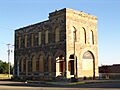
Granville State Bank
The Granville State Bank building is located at Main and 2nd Streets in Granville. It became a historic place on September 13, 1977. This building is a great example of the kind of architecture used for banks in the past. It reminds us of how towns grew and how important banks were for communities.
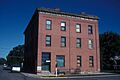
Hotel Berry
You can find the Hotel Berry at 100 West Central Avenue in Velva. This hotel was added to the list on October 20, 1982. Hotels like this were once busy places where travelers would stay. They often played a big role in the social life of a town.
Liberty Baptist Church
The Liberty Baptist Church is located at 5th and Christina Streets in Kief. It was recognized as historic on October 16, 1987. Churches are often important parts of a community's history, showing how people gathered for worship and built their towns.
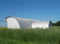
Lower Souris National Wildlife Refuge Airplane Hangar
This airplane hangar is at 681 Salyer Road in Upham. It was listed on September 20, 2011. An airplane hangar is a building where airplanes are kept. This one is special because it's part of the Lower Souris National Wildlife Refuge, which is a place that protects wild animals and their homes.
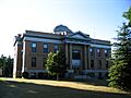
McHenry County Courthouse
The McHenry County Courthouse is located right in Towner. It became a historic site on November 25, 1980. A courthouse is where important legal decisions are made and where the county government works. This building shows the history of how McHenry County has been governed over the years.
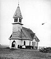
Norway Lutheran Church and Cemetery
About 10 miles south of Denbigh, south of the Souris River, you'll find the Norway Lutheran Church and Cemetery. This site was added to the National Register on October 14, 1994. It represents the history of early settlers in the area, many of whom came from Norway, and how they built their communities and places of worship.
Old Saint John Nepomocene Cemetery, Wrought-Iron Cross Site
This historic cemetery is located near Orrin. It was listed on October 23, 1989. What makes this cemetery special are the unique wrought-iron crosses used as grave markers. These crosses are beautiful examples of old craftsmanship and tell us about the people who lived here long ago.
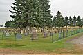
Old Saints Peter and Paul Cemetery, Wrought-Iron Cross Site
Similar to the previous one, this cemetery is near Karlsruhe and was also listed on October 23, 1989. It also features special wrought-iron crosses. These cemeteries are important for understanding the cultural heritage and artistic traditions of the early settlers in McHenry County.
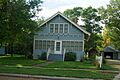
Alfred and Clara Sevareid House
The Alfred and Clara Sevareid House is at 405 2nd Street West in Velva. It became a historic place on October 3, 1996. This house is important because it was the home of Alfred Sevareid and his family. Alfred Sevareid was the father of Eric Sevareid, a famous journalist. Historic homes help us learn about the lives of people who shaped the past.
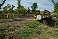
Westgaard Bridge
The Westgaard Bridge is another historic bridge, found on a county road about 6 miles north and 1 mile east of Voltaire. It crosses the Sheyenne River. This bridge was added to the list on February 27, 1997, the same day as the Elliott Bridge. Like other historic bridges, it shows us the engineering and transportation history of the area.
Images for kids
-
Granville State Bank
-
Hotel Berry
-
Lower Souris National Wildlife Refuge Airplane Hangar
-
McHenry County Courthouse
-
Norway Lutheran Church
-
Old Saints Peter and Paul Cemetery
-
Alfred and Clara Sevareid House
-
Westgaard Bridge


.jpg)


