Upham, North Dakota facts for kids
Quick facts for kids
Upham
|
|
|---|---|

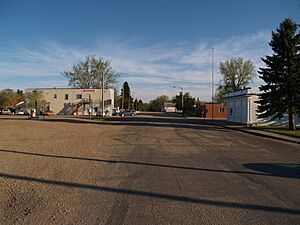
Upham in May, 2008
|
|

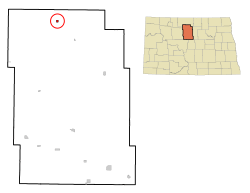
Location of Upham, North Dakota
|
|
| Country | United States |
| State | North Dakota |
| County | McHenry |
| Founded | 1905 |
| Area | |
| • Total | 0.31 sq mi (0.80 km2) |
| • Land | 0.31 sq mi (0.80 km2) |
| • Water | 0.00 sq mi (0.00 km2) |
| Elevation | 1,447 ft (441 m) |
| Population
(2020)
|
|
| • Total | 135 |
| • Estimate
(2022)
|
131 |
| • Density | 435.48/sq mi (167.87/km2) |
| Time zone | UTC-6 (Central (CST)) |
| • Summer (DST) | UTC-5 (CDT) |
| ZIP code |
58789
|
| Area code(s) | 701 |
| FIPS code | 38-80860 |
| GNIS feature ID | 1036305 |
Upham is a small city located in McHenry County, North Dakota, in the United States. In 2020, about 135 people lived there. It's part of the larger Minot area. Upham was started in 1905.
Contents
Upham's Location and Size
Upham is a small city in North Dakota. It covers an area of about 0.80 square kilometers (0.31 square miles). All of this area is land, meaning there are no large lakes or rivers within the city limits.
How Many People Live in Upham?
The number of people living in Upham has changed over the years. Here's a look at the population counts from different years:
| Historical population | |||
|---|---|---|---|
| Census | Pop. | %± | |
| 1910 | 296 | — | |
| 1920 | 196 | −33.8% | |
| 1930 | 257 | 31.1% | |
| 1940 | 243 | −5.4% | |
| 1950 | 403 | 65.8% | |
| 1960 | 333 | −17.4% | |
| 1970 | 272 | −18.3% | |
| 1980 | 227 | −16.5% | |
| 1990 | 205 | −9.7% | |
| 2000 | 155 | −24.4% | |
| 2010 | 130 | −16.1% | |
| 2020 | 135 | 3.8% | |
| 2022 (est.) | 131 | 0.8% | |
| U.S. Decennial Census 2020 Census |
|||
Life in Upham: A Closer Look at the Community
In 2010, there were 130 people living in Upham. These people lived in 67 different homes. About half of these homes were families, while the other half were individuals living alone or with roommates.
The average age of people in Upham in 2010 was 47 years old. About 18.5% of the residents were under 18. Also, 18.5% were 65 years or older. More males lived in Upham than females at that time.
Upham's Climate
Upham has a type of weather called a humid continental climate. This means it has big differences in temperature between seasons. Summers are usually warm to hot, and can sometimes be humid. Winters are cold, and can even be very cold.
| Climate data for Upham 3 N, North Dakota (1991–2020 normals, extremes 1945–present) | |||||||||||||
|---|---|---|---|---|---|---|---|---|---|---|---|---|---|
| Month | Jan | Feb | Mar | Apr | May | Jun | Jul | Aug | Sep | Oct | Nov | Dec | Year |
| Record high °F (°C) | 58 (14) |
66 (19) |
77 (25) |
98 (37) |
100 (38) |
104 (40) |
108 (42) |
105 (41) |
102 (39) |
95 (35) |
76 (24) |
60 (16) |
108 (42) |
| Mean daily maximum °F (°C) | 16.7 (−8.5) |
22.1 (−5.5) |
34.8 (1.6) |
53.0 (11.7) |
66.5 (19.2) |
75.1 (23.9) |
80.5 (26.9) |
80.3 (26.8) |
70.3 (21.3) |
54.2 (12.3) |
35.7 (2.1) |
21.9 (−5.6) |
50.9 (10.5) |
| Daily mean °F (°C) | 6.6 (−14.1) |
11.1 (−11.6) |
24.3 (−4.3) |
40.8 (4.9) |
54.2 (12.3) |
64.0 (17.8) |
68.7 (20.4) |
67.0 (19.4) |
56.8 (13.8) |
42.0 (5.6) |
25.7 (−3.5) |
12.4 (−10.9) |
39.5 (4.2) |
| Mean daily minimum °F (°C) | −3.6 (−19.8) |
0.2 (−17.7) |
13.8 (−10.1) |
28.7 (−1.8) |
41.9 (5.5) |
52.8 (11.6) |
56.8 (13.8) |
53.7 (12.1) |
43.3 (6.3) |
29.7 (−1.3) |
15.7 (−9.1) |
3.0 (−16.1) |
28.0 (−2.2) |
| Record low °F (°C) | −45 (−43) |
−48 (−44) |
−38 (−39) |
−17 (−27) |
11 (−12) |
25 (−4) |
31 (−1) |
28 (−2) |
14 (−10) |
−10 (−23) |
−29 (−34) |
−42 (−41) |
−48 (−44) |
| Average precipitation inches (mm) | 0.56 (14) |
0.56 (14) |
0.77 (20) |
1.05 (27) |
2.36 (60) |
4.21 (107) |
2.77 (70) |
1.98 (50) |
1.60 (41) |
1.36 (35) |
0.84 (21) |
0.71 (18) |
18.77 (477) |
| Average snowfall inches (cm) | 8.7 (22) |
6.6 (17) |
7.0 (18) |
4.4 (11) |
1.4 (3.6) |
0.0 (0.0) |
0.0 (0.0) |
0.0 (0.0) |
0.0 (0.0) |
2.7 (6.9) |
8.0 (20) |
10.6 (27) |
49.4 (125) |
| Average precipitation days (≥ 0.01 in) | 7.4 | 6.2 | 6.5 | 6.4 | 9.7 | 12.5 | 9.7 | 7.9 | 7.4 | 7.0 | 6.8 | 7.6 | 95.1 |
| Average snowy days (≥ 0.1 in) | 6.9 | 6.0 | 5.0 | 2.3 | 0.5 | 0.0 | 0.0 | 0.0 | 0.0 | 1.4 | 5.2 | 7.5 | 34.8 |
| Source: NOAA | |||||||||||||
See also
 In Spanish: Upham (Dakota del Norte) para niños
 | Charles R. Drew |
 | Benjamin Banneker |
 | Jane C. Wright |
 | Roger Arliner Young |

