
National Register of Historic Places listings in McPherson County, Kansas facts for kids

Have you ever wondered about old buildings and places that are super important to history? In McPherson County, Kansas, there's a special list of these places! It's called the National Register of Historic Places listings in McPherson County, Kansas. This list helps protect buildings, sites, and objects that tell us a lot about the past.
When a place is on this list, it means it's recognized by the United States government as being historically important. It could be an old house, a unique bridge, or even a spot where ancient people lived. There are 25 different places in McPherson County that have earned a spot on this special list. By keeping these places safe, we can learn more about how people lived long ago and what was important to them.
Contents
What is the National Register of Historic Places?
The National Register of Historic Places is like a giant scrapbook of America's most important historical sites. It's managed by the National Park Service, which is part of the U.S. government. When a place is added to the Register, it gets special recognition. This helps people understand why the place is important and encourages them to take care of it.
Why are places added to the Register?
Places are added for many reasons. Maybe a famous person lived there, or a big historical event happened there. Sometimes, a building is just a really cool example of old architecture. Other times, it's an archaeological site that teaches us about ancient cultures. The main goal is to save these places so future generations can learn from them too!
Historic Places in McPherson County
McPherson County is home to many interesting historical sites. These places show us different parts of the county's story, from early settlements to important community buildings. Let's look at a few examples of the types of places you might find on this list.
Old Buildings and Shops
Many buildings on the list are old shops or homes that show how people lived and worked. For example, the Berquist & Nelson Drugstore Building in Lindsborg is a historic shop. It reminds us of how people bought medicines and other goods long ago. Also in Lindsborg, the Rosberg-Holmgren-Clareen Block and the Hjerpe Grocery are examples of old business buildings. These places were once busy centers of town life.
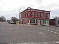
The Farmers State Bank in Lindsborg is another important building. Banks are often grand structures that show the wealth and importance of a town.
Community Hubs and Public Buildings
Some listed places were important gathering spots for the community. The Canton Township Carnegie Library in Canton is a great example. Andrew Carnegie helped build many libraries across the U.S., and these libraries became centers for learning and community events.
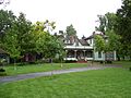
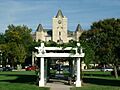
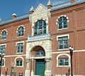
The McPherson County Courthouse in McPherson is another key public building. Courthouses are where important decisions are made and laws are upheld. The McPherson Opera House was a place for entertainment and cultural events, bringing people together for shows and performances.
The Inman I.O.O.F. Hall in Inman was a meeting place for a fraternal organization. These halls were often important social centers in small towns.
Homes of Important People
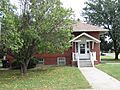
Sometimes, a house is listed because of the person who lived there. The Hans Hanson House in Marquette is one such example. Learning about these homes can tell us about the lives of the people who shaped the community. Other historic homes include the Kuns-Collier House and the John R. Wright House in McPherson.
Industrial and Agricultural Sites
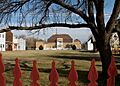
Not all historic places are buildings. Some show how people worked the land or produced goods. The Smoky Valley Roller Mill in Lindsborg is an old mill that processed grain. Mills were vital for early communities, turning crops into food.
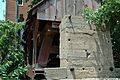
The Heinrich H. Schroeder Barn near Canton shows us about the history of farming in the area. Barns are important parts of agricultural history.
Unique Structures and Archaeological Sites
Some listings are for unique structures or places where ancient history was discovered. The North Gypsum Creek Truss Leg Bedstead Bridge is a special type of bridge. Bridges are important for connecting communities and show engineering skills from the past.
The Paint Creek Archeological Site and the Sharps Creek Archeological Site near Lindsborg are places where scientists have found clues about people who lived thousands of years ago. These sites help us understand the very first inhabitants of Kansas.
The Swedish Pavilion in Lindsborg is a unique structure that celebrates the Swedish heritage of the town. It's a reminder of the cultural roots of the area.
Images for kids
-
The Canton Township Carnegie Library.
-
The Farmers State Bank in Lindsborg.
-
The Hans Hanson House in Marquette.
-
The McPherson County Courthouse.
-
The McPherson Opera House.
-
The Smoky Valley Roller Mill.
-
The Swedish Pavilion.


