
National Register of Historic Places listings in Mingo County, West Virginia facts for kids

Have you ever wondered about really old buildings and places that are super important to history? In Mingo County, West Virginia, there are several amazing spots that are so special, they're listed on the National Register of Historic Places. This means they are officially recognized by the United States government for their historical value. It's like they're national treasures!
These places help us learn about the past and understand how people lived a long time ago. From unique buildings made of coal to historic towns and homes, Mingo County has some cool stories to tell. Let's explore some of these fascinating historic sites!
Historic Places in Mingo County
Mingo County is home to eight special places that are listed on the National Register of Historic Places. Each one has its own unique story and helps us remember important parts of history.
The Coal House: A Building Made of Coal!
The Coal House is located in Williamson, West Virginia. What makes it super cool is that it's actually built out of coal! Imagine a house made of the very thing that powered so much of West Virginia's history. This unique building was finished in 1933 and shows how important coal was to the area. It's a true symbol of the region's mining heritage.
Hatfield Cemetery: A Family's Resting Place
South of Newtown, you'll find the Hatfield Cemetery. This historic cemetery is the burial ground for members of the famous Hatfield family. The Hatfields were involved in a well-known feud with the McCoy family, which is a big part of local folklore. This cemetery helps preserve the history of this important family and their connection to the area.
Matewan Historic District: A Town with a Story
The Matewan Historic District is a whole area in the town of Matewan that is recognized for its history. This district includes many buildings and streets that look much like they did long ago. Matewan is especially famous for a major event in 1920 called the Matewan Massacre, which was a conflict related to coal miners' rights. The historic district helps us remember these important moments in labor history.
Mountaineer Hotel: A Grand Old Hotel
Also in Williamson, West Virginia, the Mountaineer Hotel is a historic building that once welcomed many travelers. Built in 1925, this hotel was a fancy place for people to stay and gather. Its grand architecture and long history make it an important landmark in Williamson. It reminds us of a time when train travel was popular and hotels were central to town life.
Historic Homes of Williamson
Several historic homes in Williamson, West Virginia are also on the National Register. These include the R. T. Price House and the Elven C. Smith House. These houses are important because they show us the architectural styles and living conditions of people from different periods in the past. They offer a glimpse into the daily lives of families who lived in Williamson many years ago.
Williamson Field House: A Community Hub
The Williamson Field House is another significant building in Williamson, West Virginia. This field house has been a central place for sports, community events, and gatherings for many years. It represents the spirit of community and recreation in Williamson, hosting countless games and activities that brought people together.
Williamson Historic District: A Whole Neighborhood of History
Finally, the Williamson Historic District is a larger area in Williamson, West Virginia that includes many historic buildings and streets. This district shows how the town grew and developed over time, especially with its connection to the Norfolk & Western railroad. Walking through this district is like taking a step back in time, seeing the architecture and layout of an early 20th-century coal town.
Images for kids
-
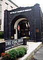
The unique Coal House in Williamson, West Virginia.
-
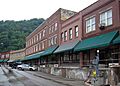
A view of the historic Matewan District.
-
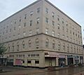
The grand Mountaineer Hotel in Williamson.
-
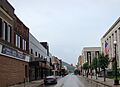
A street view of the historic district in Williamson.


