
Matewan, West Virginia facts for kids
Quick facts for kids
Matewan, West Virginia
|
|
|---|---|
.jpg)
Matewan, West Virginia.
|
|

Location of Matewan in Mingo County, West Virginia.
|
|
| Country | United States |
| State | West Virginia |
| County | Mingo |
| Area | |
| • Total | 0.55 sq mi (1.43 km2) |
| • Land | 0.55 sq mi (1.43 km2) |
| • Water | 0.00 sq mi (0.00 km2) |
| Elevation | 705 ft (215 m) |
| Population
(2020)
|
|
| • Total | 412 |
| Time zone | UTC-5 (Eastern (EST)) |
| • Summer (DST) | UTC-4 (EDT) |
| ZIP code |
25678
|
| Area code(s) | 304 |
| FIPS code | 54-52324 |
| GNIS feature ID | 1542862 |
Matewan (/ˈmeɪtwɒn/) is a small town in Mingo County, West Virginia, United States. It is located where the Tug Fork River and Mate Creek meet. In 2020, about 412 people lived there. A railway line also runs through the town. Matewan is famous for its role in the "Coal Wars" and a big event called the Battle of Matewan in 1920.
Contents
Geography of Matewan
Matewan covers a total area of about 0.56 square miles (1.43 square kilometers). All of this area is land. The town is nestled where two waterways, the Tug Fork River and Mate Creek, come together.
People Living in Matewan

In 2010, there were 499 people living in Matewan. These people made up 261 households. About 117 of these households were families. The town had about 891 people per square mile.
Most of the people in Matewan were White (91.6%). About 6.4% were African American. A small number were Native American or from two or more races.
About 19.9% of households had children under 18 living with them. Many households (52.5%) were just one person living alone. The average age of people in Matewan was 45.4 years old.
History of Matewan
The area where Matewan is located has a long and interesting history.
Early Days and Post Offices
The first post office in the area was called "Mate Creek Post Office." It opened on February 18, 1875. One of the early postmasters was Elias Hatfield. He was related to "Devil Anse" Hatfield, a famous person from the Hatfield-McCoy Feud.
Later, in 1885, the Mate Creek Post Office closed. A new one called "Sidney Post Office" opened instead.
How Matewan Got Its Name
In 1890, an engineer named Erskine Hazard planned out the town. He drew the first map of the community. The town was named after a place called Matteawan in New York. However, local people changed the spelling and how they said the name to "Matewan."

The Coal Wars and Matewan Massacre
Matewan played a big part in the "Coal Wars." These were conflicts between coal miners and coal companies. In 1920, miners tried to form a union to get better working conditions. This led to a violent event known as the Battle of Matewan. It was a fight between the miners and detectives hired by the coal companies. This event was so important that it inspired a movie called Matewan in 1987.
You can learn more about the town's history at the Matewan Depot. It has a small museum. The West Virginia Mine Wars Museum also shares the story of the mine wars.
Famous People from Matewan
Some notable people have come from Matewan:
- Sam Church – A leader in labor unions.
- John Hendricks – He started Discovery Communications, which created channels like the Discovery Channel. He also founded CuriosityStream.
- Sid Hatfield – He was the police chief in Matewan. He became famous for supporting the miners during the Matewan Massacre.
Things to See and Do in Matewan
Matewan is a great place to visit because of its rich history.
Matewan Historic District
The center of Matewan is called the Matewan Historic District. It is a special place recognized as a National Historic Landmark. This is because of its important history, including the Hatfield-McCoy feud and the Matewan Massacre. You can take interesting tours and see historical sights when you visit.
Hatfield-McCoy Trails
If you like outdoor adventures, the Hatfield-McCoy Trails have a starting point right in Matewan. This means you can easily access the trail system for riding while staying in town.
Images for kids
-
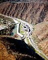
Aerial view of Matewan
-
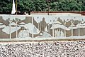
The floodwall along the Tug Fork River in Matewan shows scenes from the Hatfield-McCoy feud
See also
 In Spanish: Matewan (Virginia Occidental) para niños
