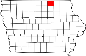
National Register of Historic Places listings in Mitchell County, Iowa facts for kids
Mitchell County, Iowa, is home to many interesting places with a rich history. These special spots are listed on the National Register of Historic Places. This list helps protect important buildings and areas across the United States. It makes sure future generations can learn from and enjoy these historic treasures.
There are 10 unique properties and districts in Mitchell County that have earned a spot on this important list. Each one tells a part of the county's story.
What is the National Register of Historic Places?
The National Register of Historic Places is like a special club for old buildings, sites, and objects. It's the official list of places in the United States that are worth saving. The National Park Service manages this list.
When a place is added to the Register, it means it's important to local, state, or national history. It could be a building where something significant happened. It might be a place that shows how people lived long ago. Or it could be a great example of old architecture. Listing a place helps protect it and can even provide money for its upkeep.
Historic Places in Mitchell County
Let's explore some of the fascinating historic places you can find in Mitchell County, Iowa. Each one has a unique story to tell about the past.
Cedar Valley Seminary
The Cedar Valley Seminary is an old school building located in Osage. It was built a long time ago and served as an important educational center. It helped shape the minds of many young people in the area. The seminary was added to the National Register in 1977.
|- class="vcard" ! style="background:#A8EDEF" | 1 | Cedar Valley Seminary
|
|
(#77000541)
| class="adr" | 200 N. 7th St.
43°17′10″N 92°48′49″W / 43.286111°N 92.813611°W
| class="note" |
Nathaniel Cobb and Lucetia Baily Deering House
This beautiful house in Osage belonged to Nathaniel Cobb and Lucetia Baily Deering. It's a great example of homes from a past era. The house was recognized for its historical value in 2001. It stands as a reminder of the families who helped build the community.
|- class="vcard" ! style="background:#A8EDEF" | 2 | Nathaniel Cobb and Lucetia Baily Deering House
|
|
(#00001678)
| class="adr" | 903 State St.
43°17′04″N 92°48′49″W / 43.284444°N 92.813611°W
| class="note" |
First Lutheran Church
The First Lutheran Church in St. Ansgar is a significant religious building. It has been a place of worship and community gathering for many years. Its architecture and long history made it eligible for the National Register in 1976.
|- class="vcard" ! style="background:#A8EDEF" | 3 | First Lutheran Church
|
|
(#76000795)
| class="adr" | 212 N. Main St.
43°22′48″N 92°55′32″W / 43.38°N 92.925556°W
| class="note" |
Mitchell County Courthouse
The Mitchell County Courthouse in Osage is where important local government decisions are made. Courthouses often have unique designs and play a central role in a county's history. This courthouse was added to the Register in 1977.
|- class="vcard" ! style="background:#A8EDEF" | 4 | Mitchell County Courthouse
|
|
(#77000542)
| class="adr" | 500 State St.
43°16′57″N 92°48′50″W / 43.2825°N 92.813889°W
| class="note" |
Mitchell Powerhouse and Dam
Located on the Red Cedar River in Mitchell, this powerhouse and dam are examples of early engineering. They show how people used natural resources to create power. This site was recognized for its historical importance in 1978.
|- class="vcard" ! style="background:#A8EDEF" | 5 | Mitchell Powerhouse and Dam
|
|
(#78001246)
| class="adr" | Red Cedar River
43°19′06″N 92°52′51″W / 43.318333°N 92.880833°W
| class="note" |
Osage Commercial Historic District
A historic district is an area with several important buildings. The Osage Commercial Historic District includes several blocks of Main Street in Osage. These buildings tell the story of how businesses and daily life developed in the town. It became a historic district on the Register in 2002.
|- class="vcard" ! style="background: #E6E6FA" | 6 | Osage Commercial Historic District
|
|
(#02001030)
| class="adr" | 700, 600, and parts of the 500 blocks of Main St.
43°17′02″N 92°48′40″W / 43.283889°N 92.811111°W
| class="note" |
Saint Ansgar Public School
The Saint Ansgar Public School building has been a place of learning for generations. Schools are often central to a community's growth and development. This school was added to the National Register in 2020, making it one of the newer listings.
|- class="vcard" ! style="background:#A8EDEF" | 7 | Saint Ansgar Public School |
|
(#100004976)
| class="adr" | 202 South Washington St.
43°22′38″N 92°55′24″W / 43.377158°N 92.923263°W
| class="note" |
Nels Severson Barn
Barns are important parts of agricultural history. The Nels Severson Barn, located north of Carpenter, is a great example of early farm structures. It shows how farming was done in the past. This barn was listed on the Register in 1977.
|- class="vcard" ! style="background:#A8EDEF" | 8 | Nels Severson Barn |
|
(#77000540)
| class="adr" | North of Carpenter
43°25′21″N 93°00′40″W / 43.4225°N 93.011111°W
| class="note" |
Union Presbyterian Church
Another important religious building, the Union Presbyterian Church is located northwest of Stacyville. Churches often serve as community hubs and hold many memories for local residents. This church was added to the National Register in 1977.
|- class="vcard" ! style="background:#A8EDEF" | 9 | Union Presbyterian Church
|
|
(#77000543)
| class="adr" | Northwest of Stacyville
43°28′47″N 92°48′35″W / 43.479722°N 92.809722°W
| class="note" |
Walnut Grove School
The Walnut Grove School, located in Osage, is another historic school building. These one-room or small schools were once common in rural areas. They played a huge role in educating children in their local communities. It was added to the Register in 2002.
|- class="vcard" ! style="background:#A8EDEF" | 10 | Walnut Grove School
|
|
(#02001028)
| class="adr" | 3272 Foothill Ave.
43°14′16″N 92°55′10″W / 43.237778°N 92.919444°W
| class="note" | |}
| Osage | Osage | St. Ansgar | Osage | Mitchell | Osage | St. Ansgar | Carpenter | Stacyville | Osage |


