Osage, Iowa facts for kids
Quick facts for kids
Osage, Iowa
|
|
|---|---|

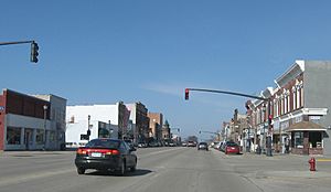
Downtown Osage, Iowa.
|
|

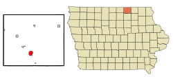
Location of Osage, Iowa
|
|
| Country | United States |
| State | Iowa |
| County | Mitchell |
| Incorporated | April 14, 1871 |
| Area | |
| • Total | 2.24 sq mi (5.81 km2) |
| • Land | 2.24 sq mi (5.81 km2) |
| • Water | 0.00 sq mi (0.00 km2) |
| Elevation | 1,181 ft (360 m) |
| Population
(2020)
|
|
| • Total | 3,627 |
| • Density | 1,617.75/sq mi (624.63/km2) |
| Time zone | UTC-6 (Central (CST)) |
| • Summer (DST) | UTC-5 (CDT) |
| ZIP codes |
50454, 50461
|
| Area code(s) | 641 |
| FIPS code | 19-59745 |
| GNIS feature ID | 0459903 |
Osage is a city in Mitchell County, Iowa, United States. It is also the county seat, which means it's where the county government is located. In 2020, about 3,627 people lived there.
Contents
Geography and Climate
Osage is located in Iowa at coordinates 43°17′5″N 92°48′44″W. The city covers an area of about 2.24 square miles (5.81 square kilometers), all of which is land.
The climate in Osage has warm summers and cold winters. Temperatures can get very hot in July, sometimes reaching over 100°F (38°C). In winter, especially January and February, temperatures can drop below 0°F (-18°C). The city gets a good amount of rain, especially in spring and summer, and also experiences snowfall in winter.
Population and People
Osage has seen its population change over the years. Here's a quick look at how many people have lived there:
| Historical populations | ||
|---|---|---|
| Year | Pop. | ±% |
| 1870 | 1,400 | — |
| 1880 | 2,012 | +43.7% |
| 1890 | 1,913 | −4.9% |
| 1900 | 2,734 | +42.9% |
| 1910 | 2,445 | −10.6% |
| 1920 | 2,878 | +17.7% |
| 1930 | 2,964 | +3.0% |
| 1940 | 3,196 | +7.8% |
| 1950 | 3,436 | +7.5% |
| 1960 | 3,753 | +9.2% |
| 1970 | 3,815 | +1.7% |
| 1980 | 3,718 | −2.5% |
| 1990 | 3,439 | −7.5% |
| 2000 | 3,451 | +0.3% |
| 2010 | 3,619 | +4.9% |
| 2020 | 3,627 | +0.2% |
| Source: and Iowa Data Center Source: |
||
What the 2020 Census Shows
In 2020, Osage had 3,627 residents. There were 1,620 households, with many different types of families living in them. Most people in Osage (about 93.9%) are White. Other groups include Black or African American, Native American, Asian, and Pacific Islander people. About 2.2% of the population identified as Hispanic or Latino.
The average age in Osage was about 45.8 years old. Many residents (23.2%) were under 20, and a large number (25.8%) were 65 or older. The city has slightly more females (52.8%) than males (47.2%).
What the 2010 Census Showed
In 2010, Osage had 3,619 people. The city had 1,614 households. Most residents (98.1%) were White. About 1.3% of the population was Hispanic or Latino.
The average age was 45.2 years. About 22.5% of the people were under 18. Similar to 2020, there were more females (53.5%) than males (46.5%) living in Osage.
History of Osage
The town of Osage began in 1854. It was first called "Cora" by Dr. Moore, but that name was never officially recorded. In 1855, a man named Mr. Gibbs came to the area. He convinced a wealthy banker named Mr. Orrin Sage to invest in the community. Mr. Sage later gave money and land for a library. Because of his kindness, the town's name was changed to Osage in his honor.
In 1856, Dr. S. B. Chase planned out the city we see today. He named the streets after trees and numbered others. He also made sure maple trees were planted along the streets. This is why Osage is still known as "the City of Maples." Dr. Chase built a large house and office in 1869, which is still standing and used as apartments. Ten years after he passed away in 1891, Free Street was renamed Chase Street to remember his important contributions to Osage.
Many buildings in Osage's downtown area were built in the 1870s. The current City Hall building was once the Sage Library, built in 1910 with a gift from Andrew Carnegie. The very first library was built in 1876. Today, you can still see "Sage Library" and the date 1876 on the second story of a building that now has a Subway sandwich shop.
In 2002, a four-block area of Main Street was added to the National Register of Historic Places. This means it's recognized as an important historical area. Main Street is 100 feet wide and was first paved in 1910. It was repaved in 1975, and new sidewalks and trees were added. This project was even named the best municipal paving project in Iowa that year!
Fun Places to Visit
Cedar River Complex (CRC)
The Cedar River Complex is a great place for fun and learning in Osage. It has an events center for gatherings, a wellness center for staying active, a museum to learn about local history, and an auditorium for shows. It's a place where people can meet, play, and enjoy themselves.
Watts Theatre
The Watts Theatre first opened in 1950. It was a modern movie theater with 580 seats and even living space for the Watts family upstairs!
In 1994, Paul and Gloria Bunge bought the theater. It had been closed and emptied, but they worked hard to bring it back to life. They added new heating, air conditioning, projection equipment, and a sound system. They also installed 364 new, comfortable seats. The theater reopened on June 14, 1994, showing the same movie it first showed: "Dancing in the Dark."
The theater was sold again in 1998 to the Williams family, who made more improvements like a new roof and upgraded equipment. In 2006, the Walk Family became the new owners.
Education
The Osage Community School District is in charge of the public schools in the area.
There used to be a private school called Sacred Heart School, which opened in 1957. However, the number of students kept getting smaller, and it closed in 2012.
Famous People from Osage
Many interesting people have connections to Osage:
- Margaret Stoughton Abell (1908–2004) was born here. She was the first woman research forester.
- James Vincent Casey was a Roman Catholic bishop.
- Steve Darrell (1904–1970) was an actor.
- Randy Duncan was a football quarterback who was a top player in the Big Ten Conference and a runner-up for the Heisman Trophy.
- Hamlin Garland was a famous writer of novels, poems, and short stories.
- Edward Dean Jeffries was known for designing custom vehicles and working as a stunt man in movies.
- Mike Johanns was a former Governor of Nebraska, a United States Secretary of Agriculture, and a US Senator.
- Alan Larson (born 1949) is a diplomat and ambassador.
- Gerald Leeman won a silver medal in freestyle wrestling at the 1948 Summer Olympic Games and was a college wrestling champion.
- Troy Merritt is a professional golfer on the PGA Tour.
- Tiny Sandford was an actor who appeared in films with Charlie Chaplin and Laurel and Hardy.
- Doug Schwab was an Olympic wrestler in 2008.
See also
 In Spanish: Osage (Iowa) para niños
 | DeHart Hubbard |
 | Wilma Rudolph |
 | Jesse Owens |
 | Jackie Joyner-Kersee |
 | Major Taylor |

