
National Register of Historic Places listings in Montgomery County, Kansas facts for kids

Welcome to Montgomery County, Kansas! Did you know that many buildings, bridges, and even old Native American sites here are super important? They are so special that they've been added to a list called the National Register of Historic Places. This list helps protect and celebrate places that tell us about America's past. In Montgomery County, there are 35 amazing spots on this list!
What is the National Register of Historic Places?
The National Register of Historic Places is like a special hall of fame for buildings, structures, objects, sites, and districts that are important in American history. When a place is added to this list, it means it has a unique story to tell about our country's past. It could be a place where something important happened, or a building with cool architecture. Being on the list helps people understand why these places are valuable and encourages their protection.
Cool Historic Buildings and Homes
Montgomery County has many interesting buildings that have been around for a long time. These places often show us how people lived, worked, and gathered in the past.
The W.P. Brown Mansion

One of the most famous homes on the list is the W.P. Brown Mansion in Coffeyville. This huge house was built by a wealthy businessman named W.P. Brown. It's a great example of fancy homes from the late 1800s. Imagine living in a house with so many rooms and details! It was added to the list in 1976.
Condon National Bank

Also in Coffeyville is the Condon National Bank. This building is famous for a dramatic event that happened there. In 1892, the notorious Dalton Gang tried to rob this bank and another one nearby. The citizens of Coffeyville fought back, and the gang was defeated. This building stands as a reminder of that wild day in history. It joined the Register in 1973.
Carnegie Libraries
Libraries are super important places for learning, and some of the oldest ones in Montgomery County are on the historic list. These are called "Carnegie Libraries" because they were built with money donated by Andrew Carnegie, a very rich businessman who believed in the power of education.
- The Cherryvale Carnegie Free Library in Cherryvale was listed in 1987.
- The Coffeyville Carnegie Public Library Building was also listed in 1987.
- The Independence Public Carnegie Library in Independence joined the list in 1988.
These libraries are not just places to read books; they are also beautiful historic buildings that show how communities valued learning long ago.
Historic Bridges
Bridges help us cross rivers and valleys, and some old bridges are also considered historic. They show us how engineers and builders worked in the past.
Dewlen-Spohnhauer Bridge

The Dewlen-Spohnhauer Bridge near Independence is a great example of an old metal bridge. It was built a long time ago and is important because of its design. It was added to the Register in 1983.
Onion Creek Bridge

Another interesting bridge is the Onion Creek Bridge, located south of Coffeyville. This bridge, built over Onion Creek, is also recognized for its historical importance in transportation. It was listed in 1990.
Ancient History: Archeological Sites
Some of the oldest places on the list aren't buildings at all! They are archeological sites, which are places where scientists study the remains of ancient human activity. These sites can be thousands of years old and tell us about the people who lived in Kansas long before modern towns existed.
- Archeological Site Number 14MY1
- Archeological Site Number 14MY365
- Archeological Site Number 14MY1320
- Archeological Site Number 14MY1385
- The Eastep Site
- The Elk River Archeological District
- The Infinity Archeological Site
These sites are often kept secret to protect them, but they are incredibly important for understanding the very first people who called this area home.
Other Cool Spots
Montgomery County has many other interesting places on the National Register:
- Blakeslee Motor Company Building: An old building in Independence that used to be a car dealership.
- Booth Hotel and Booth Theater: These places in Independence show us what entertainment and travel were like in the past.
- Brown Barn and Cedar Manor Farm: These historic farms tell us about the history of farming in Kansas.
- Cook's Hotel: Another historic hotel in Independence.
- Federal Building-US Post Office: A government building in Independence that has served the community for many years.
- First Congregational Church: An old church building in Independence.
- Hotel Dale: A historic hotel in Coffeyville.
- Independence Bowstring: Another historic bridge over the Verdigris River.
- Independence Downtown Historic District: This isn't just one building, but a whole area in downtown Independence with many historic buildings.
- Independence Junior High School and Washington School: Old school buildings that taught many generations of students.
- Memorial Hall: A building in Independence that often hosts events and honors important people.
- Midland Theater: A historic theater in Coffeyville where people used to watch movies and shows.
- Pennsylvania Avenue Rock Creek Bridge: Another historic bridge in Independence.
- Terminal Building: An old building in Coffeyville.
- Union Implement and Hardware Building-Masonic Temple: A building in Independence that once housed a hardware store and a meeting place for a fraternal organization.
These are just some of the many amazing places in Montgomery County that are part of the National Register of Historic Places. Each one has a unique story and helps us learn about the past!
Images for kids
-
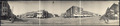
A view of downtown Independence, part of the historic district.
-
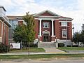
The Independence Public Carnegie Library.

