
National Register of Historic Places listings in Muscatine County, Iowa facts for kids

Have you ever wondered about old buildings and places that are super important to history? In Muscatine County, Iowa, there's a special list of these places! It's called the National Register of Historic Places. This list helps protect buildings, bridges, and other spots that tell us stories about the past.
When a place is on this list, it means it's recognized by the United States government as being very important. It could be important because of its history, its amazing architecture, or because of famous people who lived or worked there. There are 36 such places in Muscatine County right now. One place was on the list but has since been removed. Let's explore some of these cool historic sites!
Contents
What is the National Register of Historic Places?
The National Register of Historic Places is like a special club for old buildings and sites. It's the official list of places in the U.S. that are worth saving. These places are often old homes, churches, schools, bridges, or even whole neighborhoods.
Why are places added to the list?
Places get added to this list for many reasons. Maybe a famous person lived there, or an important event happened there. Sometimes, a building is just a really great example of a certain style of architecture. Being on the list helps people understand why these places are special and encourages them to take care of them.
Historic Places in Muscatine County
Muscatine County has a rich history, and many of its important places are on the National Register. These sites are spread across different towns like Muscatine, West Liberty, Nichols, and Wilton.
Muscatine City Highlights
The city of Muscatine has many historic gems. You can find old homes, churches, and even a historic downtown area.
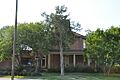
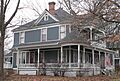
Alexander Clark House
The Alexander Clark House at 203 W. 3rd Street is a significant home. Alexander Clark was an important leader who fought for civil rights. His house was added to the list in 1976.
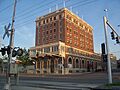
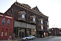
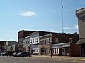
Downtown Commercial Historic District
Imagine walking through a part of Muscatine that looks much like it did long ago! The Downtown Commercial Historic District includes many old shops and buildings. It's centered around 2nd Street and was added to the list in 2006.
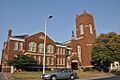
First Presbyterian Church
The First Presbyterian Church at 401 Iowa Avenue is a beautiful old church. It was recognized for its historical importance in 1977.
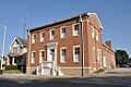
Muscatine County Courthouse
The Muscatine County Courthouse on 3rd Street is where a lot of important county decisions have been made over the years. This grand building became a historic site in 1981.
Old Jail
Yes, Muscatine even has an Old Jail on the list! Located at 411 E. 4th Street, this building tells a story about law and order from the past. It was listed in 1974.
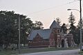
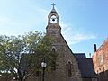
Trinity Episcopal Church
Another historic church, the Trinity Episcopal Church at 411 E. 2nd Street, was added to the list in 1974. It's a great example of historic church architecture.
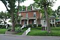
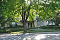
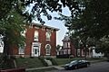
West Hill Historic District
The West Hill Historic District is another area in Muscatine with many historic homes. It's a great place to see how people lived in the past. This district was added in 2008.
West Liberty and Nearby Areas
West Liberty and its surroundings also have several important historic places.
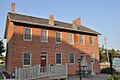
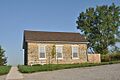
Beers and St. John Company Coach Inn
The Beers and St. John Company Coach Inn near West Liberty is a very old inn. It was a place where travelers could stop and rest long ago. It was added to the list in 2016.
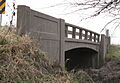
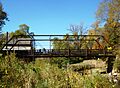
Bridge near West Liberty
There's a historic bridge near West Liberty on 120th Street. It's a reminder of how people traveled and built roads in the past. This bridge was listed in 1998.
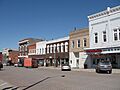
West Liberty Commercial Historic District
Just like Muscatine, West Liberty has its own historic downtown area. It includes buildings along 4th Street and was recognized in 2002.
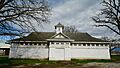
West Liberty Fairgrounds Historic District
The Muscatine County Fairgrounds in West Liberty is also a historic district. Fairs have been held here for many years, making it an important community spot. It was added to the list in 2015.
Wilton's Historic Spots
The town of Wilton has a couple of unique historic places.
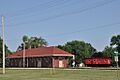
Chicago, Rock Island and Pacific Railroad-Wilton Depot
The old train station, the Chicago, Rock Island and Pacific Railroad-Wilton Depot, is on N. Railroad Street. It was a busy place when trains were the main way to travel. It became historic in 1988.
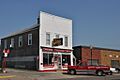
Wilton Candy Kitchen
Who doesn't love candy? The Wilton Candy Kitchen at 310 Cedar Street is a super cool historic candy store. It's been around for a very long time and was added to the list in 1993.
Wilton Commercial Historic District
Wilton also has a historic commercial area. This district shows what the town looked like when it was first growing. It was listed in 2016.
Other Notable Sites in Muscatine County
Beyond the main towns, there are other interesting historic places scattered throughout the county.
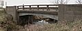
Big Slough Creek Bridge
Near Nichols, you can find the Big Slough Creek Bridge on Bancroft Avenue. This bridge is another example of important old engineering. It was listed in 1998.
Pine Creek Gristmill
In Wildcat Den State Park, northeast of Muscatine, is the Pine Creek Gristmill. A gristmill is where grain was ground into flour. This historic mill was added to the list in 1979.
Pine Mill Bridge
Also in Wildcat Den State Park, the Pine Mill Bridge crosses Pine Creek. It's another historic bridge that helps tell the story of the area. It was listed in 1998.
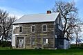
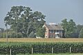
Sinnett Octagon House
North of Muscatine, there's a very unusual house called the Sinnett Octagon House. It's shaped like an octagon (an eight-sided figure)! This unique home was listed in 1974.
Images for kids
-
The Beers and St. John Company Coach Inn
-
Big Slough Creek Bridge
-
Bridge near West Liberty
-
Chicago, Rock Island and Pacific Railroad-Wilton Depot
-

Alexander Clark House
-

Clark-Blackwell House
-
Downtown Commercial Historic District
-
Pliny and Adelia Fay House
-
First Presbyterian Church
-
W. Joseph Fuller House
-
Greenwood Cemetery Chapel
-

Lock and Dam No. 16
-
S. M. McKibben House
-

Muscatine County Courthouse
-
Samuel Nichols House
-
Old Jail
-

Pine Creek Gristmill
-
Pine Mill Bridge
-
Pine Mills German Methodist Episcopal Church
-
Sinnett Octagon House
-
Trinity Episcopal Church
-
George H. and Loretta Ward House
-

J. C. B. Warde House
-
Welch Apartments
-
West Hill Historic District
-
West Liberty Commercial Historic District
-
West Liberty Fairgrounds Historic District
-
Wilton Candy Kitchen
-
Wilton Commercial Historic District


_from_SE_3.JPG)


