
National Register of Historic Places listings in Nash County, North Carolina facts for kids

Imagine buildings, farms, and even whole neighborhoods that are so special, they're officially recognized as important parts of history! In Nash County, North Carolina, there are many such places listed on the National Register of Historic Places. This special list helps protect these places so future generations can learn from them and enjoy them. Let's explore some of these amazing historic spots!
Contents
What is the National Register of Historic Places?
The National Register of Historic Places is the official list of the United States' historic places that are worth saving. It's like a special hall of fame for buildings, sites, districts, structures, and objects that have played a big role in American history, architecture, archaeology, engineering, or culture.
When a place is added to this list, it means it's recognized for its importance. This recognition can help protect it from being torn down or changed too much. It also helps people learn about the past and appreciate the stories these places tell.
Why are These Places Important?
These historic places in Nash County are like time capsules. They show us how people lived, worked, and built things many years ago. They can be old homes, schools, mills, or even entire areas with many historic buildings. By preserving them, we keep a connection to our past and understand how our communities grew.
For example, an old mill might tell us about how people used to make flour or textiles. A historic house might show us the style of homes from a different century. These places are not just old; they are valuable lessons about history right in our own backyard!
Historic Homes and Buildings
Nash County is home to many historic houses, each with its own story. These homes often show different styles of architecture from the past.
- Gen. Joseph Arrington House: This old house, listed in 1974, is near Hilliardston, North Carolina. It's a reminder of early life in the county.
- Bellamy-Philips House: Located near Battleboro, North Carolina, this house was added to the list in 1982.
- Bellemonte: Found in Rocky Mount, North Carolina, Bellemonte was recognized in 1989.
- Benvenue: Also in Rocky Mount, this historic spot joined the list in 1982.
- Bissette-Cooley House: This house in Nashville, North Carolina, became historic in 1985.
- Black Jack: North of Red Oak, North Carolina, this property was listed in 1974.
- Dr. Hassell Brantley House: In Spring Hope, North Carolina, this house was added in 1986.
- Burt-Arrington House: Another historic home near Hilliardston, listed more recently in 2016.
- Dortch House: This house near Dortches, North Carolina, has been on the list since 1972.
- Machaven: In Rocky Mount, Machaven was recognized in 1980.
- The Meadows: Northwest of Battleboro, this property was listed in 1974.
- Rose Hill: North of Nashville, Rose Hill became a historic place in 1982.
- Stonewall: Located in Rocky Mount, Stonewall has been on the list since 1970.
- Valentine-Wilder House: Near Spring Hope, this house was added to the list in 2013.
Important Community Buildings
Beyond homes, other buildings that served the community are also recognized for their historical value.
- Morgan School: This school in Bailey, North Carolina, was listed in 2006. Old schools often show us how education has changed over time.
- Nash County Courthouse: The courthouse in Nashville, North Carolina, is where important legal decisions have been made for many years. It was added to the list in 1979.
- Red Oak Community House: This building in Red Oak, North Carolina, recognized in 2006, likely served as a gathering place for the community.
- Rocky Mount Electric Power Plant: This plant in Rocky Mount, North Carolina, listed in 1982, shows how cities developed and got electricity.
Historic Mills
Mills were very important in the past for grinding grain or making textiles. Nash County has a few historic mills.
- Bellamy's Mill: Southwest of Enfield, North Carolina, this mill was listed in 1974.
- Rocky Mount Mills: In Rocky Mount, this mill was recognized in 1980. It's a great example of early industrial history in the area.
- Taylor's Mill: West of Middlesex, North Carolina, this mill was added to the list in 1980.
Historic Districts
Sometimes, it's not just one building that's important, but a whole group of buildings or a neighborhood. These are called historic districts.
- Falls Road Historic District: This district in Rocky Mount was listed in 1999. It includes several streets with historic buildings.
- Dr. Franklin Hart Farm: This farm near Drake was recognized in 1988. Farms often tell stories about how people lived off the land.
- Nashville Historic District: A large part of downtown Nashville, North Carolina, was recognized as a historic district in 1987.
- Rocky Mount Central City Historic District: This large district in Rocky Mount, listed in 1980, covers many blocks and shows the city's growth.
- Rocky Mount Mills Village Historic District: This district, listed in 1999, is near the Rocky Mount Mills. It likely includes homes where mill workers lived.
- Spring Hope Historic District: A significant part of Spring Hope, North Carolina, was recognized in 1988.
- Villa Place Historic District: Another district in Rocky Mount, listed in 1999, with a boundary increase in 2002.
- West Haven Historic District: This district in Rocky Mount was added in 2002.
Images for kids
-
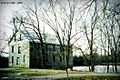
Bellamy's Mill
-
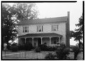
The Dortch House
-
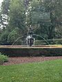
Rose Hill
.jpg)

