
National Register of Historic Places listings in Natchitoches Parish, Louisiana facts for kids

Have you ever wondered about old buildings and places that tell stories from the past? In Natchitoches Parish, Louisiana, there are many such special spots! These places are so important that they are listed on the National Register of Historic Places. This is like a special list kept by the United States government. It helps protect buildings, sites, and objects that are important to American history, architecture, archaeology, engineering, or culture.
Natchitoches Parish is home to 37 places on this list. Five of these are even more special, called National Historic Landmarks. These landmarks are considered to be among the most important historic places in the entire country! One place was once on the list but was later removed. Let's explore some of these amazing historic sites.
Contents
Historic Plantations and Homes
Natchitoches Parish has many beautiful old plantations and homes. These places often show us what life was like long ago, especially in the days of large farms.
Famous Plantations
- Melrose Plantation: This is a very famous place! It's known for its unique history and connection to African-American culture and art. It was founded by Marie Thérèse Coincoin, a former slave who became a successful businesswoman.
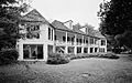
- Magnolia Plantation: Another important plantation, Magnolia, has many original buildings still standing. It helps us understand how these large farms operated.
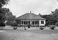
- Oakland Plantation: Also known as Jean Pierre Emmanuel Prud'homme Oakland Plantation, this site is part of the Cane River Creole National Historical Park. It's a great example of a Creole plantation.
Other Notable Homes
Many other homes are also on the list, each with its own story:
- Badin-Roque House: An old house near Natchez.
- Briarwood: This was the home of Caroline Dorman, a famous botanist and conservationist. She loved nature and worked hard to protect Louisiana's plants and animals.
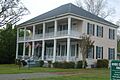
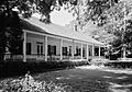
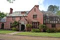
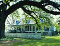
- Cherokee Plantation: Located southeast of Natchitoches, this plantation shows us more about the region's agricultural past.
- Maison De Marie Therese: This house is connected to Marie Thérèse Coincoin, the founder of Melrose Plantation.
- Jones House and Jerry Jones House: These homes along Cane River Lake offer glimpses into the lives of families who lived there.
- John Carroll Jones House: Another historic home near Natchez.
- Keegan House (Natchitoches) and Keegan House (Robeline): Two different houses named Keegan, showing different styles of homes from the past.
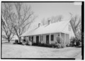
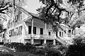
- Narcisse Prudhomme Plantation: Also known as Beau Fort, this plantation is another example of the area's rich history.
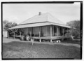
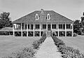
- Oaklawn Plantation: East of Natchez, this plantation adds to the collection of historic farms in the parish.
Historic Districts and Schools
Some areas in Natchitoches Parish are so full of historic buildings that they are called "historic districts." This means a whole group of buildings in that area is protected.
Natchitoches Historic District
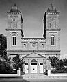
The heart of the city of Natchitoches is a large historic district. It includes many old buildings, shops, and homes. Walking through this area is like stepping back in time! The beautiful Church of the Immaculate Conception is one of the important buildings in this district.
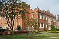
Northwestern State University Historic Districts
Northwestern State University has two historic districts on its campus:
- Normal Hill Historic District: This area covers the older parts of the university campus.
- Northwestern State University Historic District: This is a larger district that might include more of the university's historic buildings, like the A.A. Fredericks Auditorium.
- President's Home, Northwestern State University: The home where the university president lives is also a historic building.
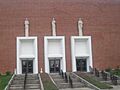
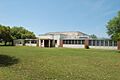
- Women's Gymnasium, Northwestern State University: This old gym is another important building on campus.
Other Important Historic Sites
Beyond homes and districts, Natchitoches Parish has other unique places on the National Register.
Churches and Community Buildings
- Church of St. Anne: Located in Allen, this church is a significant part of the community's history.
- Robeline Methodist Church: An old church in Robeline that has served its community for many years.
- St. Augustine Catholic Church and Cemetery: This site near Natchez includes both a historic church and its cemetery, telling stories of generations.
- St. Matthew High School: This old school in Melrose played an important role in educating students in the area.
Stores and Businesses
- Carnahan Store: An old store in Cloutierville, showing what local businesses were like in the past.
- Caspiana Plantation Store: This store in Natchitoches was once part of a plantation.
- Flora Commissary: A commissary was like a general store, often found on plantations or in small towns, where people could buy supplies.
Archaeological Sites
Some listings are not buildings but important archaeological sites. These are places where scientists study artifacts and remains to learn about ancient cultures.
- Fish Hatchery 2 Site: This site near Natchitoches is restricted, meaning its exact location is kept secret to protect it.
- Fredericks Site: Another restricted archaeological site near Clarence.
Transportation and Forts
- Texas and Pacific Railroad Depot: This old train station in Natchitoches was a busy place when trains were the main way to travel and transport goods.
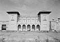
- Los Adaes: This is a very important National Historic Landmark! It was once the capital of Spanish Texas from 1729 to 1770. It was a Spanish fort and mission, showing the early history of European settlement in the area.
Former Listings
Sometimes, a place might be removed from the National Register. This usually happens if the building is destroyed or changes too much.
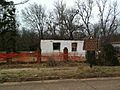
- Kate Chopin House: This house in Cloutierville was once on the list. It was the home of famous writer Kate Chopin. Sadly, it was destroyed by fire in 2008 and was removed from the list in 2015.
These historic places in Natchitoches Parish are like open books, each telling a part of Louisiana's rich and diverse history. Protecting them helps us remember and learn from the past for generations to come.
Images for kids
-
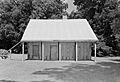
Badin-Roque House
-
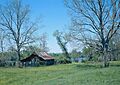
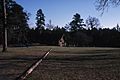
Log house in the Cane River Creole National Historical Park
-
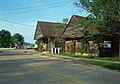
Carnahan Store
-
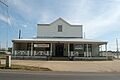
Caspiana Plantation Store
-
Cherokee Plantation house
-
Jones House
-
Keegan House in Robeline
-
Los Adaes
-
Magnolia Plantation
-
Maison De Marie Therese
-
Melrose Plantation
-
Narcisse Prudhomme Plantation, also known as Beau Fort
-
Church of the Immaculate Conception in Natchitoches Historic District
-
A.A. Fredericks Auditorium at Northwestern State University
-
Oaklawn Plantation house
-
President's Home, Northwestern State University
-
Oakland Plantation house
-
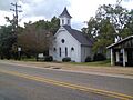
Robeline Methodist Church
-
St. Matthew High School
-
Texas and Pacific Railroad Depot
-
Women's Gymnasium, Northwestern State University
-
Ruins of the Kate Chopin House after the fire


.jpg)
.jpg)
.jpg)
.jpg)


